Exploring Astro-meteorological Analysis of Nautapa and Extreme heatwave patterns in India and the world for the monsoon condition of 2024
What is Nautapa ?
Nautapa in mundane astrology , is a traditional nine-day period of extreme heat in India, occurs during the pre-monsoon season and significantly impacts agriculture, water resources, and public health. This blog post delves into the meteorological factors behind Nautapa, historical data, and the influence of global warming on its intensity. Learn about predictions for Nautapa 2024 and discover strategies to mitigate its adverse effects on communities and the environment.
Introduction to Nautapa
This ancient Indian meteorological term, which is derived from the Sanskrit words ‘nau’ meaning nine and ‘tapa’ meaning heat, refers to a period of nine days during which the temperature is extremely high. The occurrence of this phenomena, which is firmly established in India’s cultural and agricultural fabric, typically takes place in the latter half of May or the beginning of June. The Nautapa is a key landmark on the agricultural calendar, signalling the imminent approach of the monsoon season. Nautapa is more than just a meteorological occurrence; it is also a significant marker.
These nine days see temperatures climb to their highest point of the year, which is typically reached over these nine days. Because it has an impact on both natural processes and human activity, this time period is noteworthy from a historical perspective. The farmers, in particular, keep a careful eye on Nautapa because they believe it will have an effect on the quality of the monsoon rains that are on the way. It is believed that the severe heat creates conditions that are favourable for the formation of monsoon winds, which are crucial for the existence of the country’s agricultural sector.
The cultural significance of Nautapa is represented by a number of different local traditions and folklore. There are a variety of activities and rituals that are carried out in various regions of India with the purpose of appeasing the deities and seeking relief from the heat. In addition, the cyclical nature of weather patterns, which is firmly embedded in the ancient knowledge systems that have been passed down from generation to generation, serves as a reminder during this time period.
As a consequence of this, the ground is able to take in and hold onto more heat, which is a contributing factor to the rising temperatures. The interaction between these high-pressure systems, dry air conditions, and the sun’s zenithal position results in a one-of-a-kind set of circumstances that leads to the intense heat that was witnessed during the Nautapa period. In addition, there are no substantial weather systems that could provide cooling showers or winds, which means that there is very little that can be done to alleviate the excessive heat. In order to effectively predict and prepare for Nautapa, it is essential to have a solid understanding of these climatic conditions. This will allow for improved preparedness and adaption measures to deal with the high temperatures that are expected to be experienced.
Summary of the Article : Weather Forecast in 2024 and impact of Nautapa
This year, India is expected to experience nine days of extreme heatwaves in the Jyestha month of May and June, with temperatures reaching 46-48 degrees in most Indian states. The sun will enter the Rohini Nakshatra, with Venus and Jupiter in close conjunction with Jupiter and Venus, causing severe heatwaves in the North and Northwestern states from May 25th to June 6th 2024. The Nautapa chart indicates potential catastrophic events related to water causalities, flooding, or heavy rainfall in the north & North east of india. The signs of Pisces suggest a strange weather pattern with extreme heatwaves and rainfall. From June 15th, the sun will remain in the Rohini Nakshatra, causing severe heatwaves and higher humidity in most Indian states. Astronomers should monitor the movement of winds during this period to determine the rainy season and watch for unusual sky activity, such as meteorites, comets, thunderbolts, and mock fires, which could disrupt the South Western Monsoon pattern.
The sun and moon will move into the Rohini Nakshatra on May 25, 2024, causing intense heat and warm weather that will affect most parts of the planet, particularly in India and the center world. This movement will result in the formation of strong clouds for the upcoming monsoon, which will last for two to three months from June to November. The nine days of Nautapa, or the pregnancy of clouds, are responsible for extreme heat and warm weather in India and other nations.
The sun’s intense heat in the Jala Tattva of Rohini Nakashtras accelerates the condensation cycle in coastal regions, leading to the Garabhdharan period of the monsoon. The Nau-Tapa process starts when the sun enters Rohini Nakshatra on May 25th and continues until June 3rd, 2024. The sun’s intense heat absorbs its power, causing the elements of fire and water to regenerate for crops, plants, forests, animals, and rivers, resulting in a large increase in temperature.
Storms are likely to begin in the Ashad month (June 23rd to July 21st) and continue until the 16th of July when the sun enters the Cancer sign with Venus and Mercury, causing significant rainfall in North, Western, and South Eastern regions. The Sharavana month begins on July 22nd, 2024, with a greater likelihood of storms.
Monsoon season arrival may be delayed in many states, leading to weather anomalies between August and September. These anomalies can cause unpredictable rains and flooding, particularly in coastal areas of southern India and northern regions like Jammu & Kashmir, Ladakh, and Uttarakhand.
Mundane Astrological Understanding of Nautapa based on Astro-Meteorology of 2024
In astro metrology, the role of the Sun and Mars has a bigger role in analysing the heatwave patterns during pre-monsoon and monsoon seasons, i.e., if both the Sun and Mars are closely conjugated or have close relations in the same house in Ardara Parvesh chakra, it usually gives intense dry and warm weather for that year, and there will be intense heat waves before the start of monsoon. If, in the same case, the sun is behind Mars, then there will be the possibility of no rain for the whole monsoon season. There are numerous combinations that play a significant role in analyzing heat wave patterns during the Jyestha and Shravan months of May, June, and July.
- When both the sun and Saturn align closely in a single rashi, we typically witness intense heat waves during summer, and during winter, we typically experience severe cold and copious snowfall. According to common practices, Saturn is associated with dry and cold winds, typically causing dryness and severe coldness in the atmosphere based on seasonal fluctuations. When it aligns with Jala Nadi, it typically results in Strong windstorms of water and air and storms can cause massive cyclones in coastal regions, and wrecking of ships via thunderstorms is a role of Mars when it is with Saturn or getting aspects from Mars in coastal areas. When Saturn is in an airy nadi, it typically drives away all the rain-causing clouds with its powerful wind and dryness.
- If Saturn is in Agni Nadi, it usually gives intense dry heat waves, dusty wind storms, and heavy storms, which are very powerful and can even break any buildings or obstacles in their paths.
- If there are more planets in Agni Nadi, i.e., the Sun, Mars, Jupiter, and Saturn, it will also have strong heatwave patterns.
Our sages use the Sapta nadi Chakra, an ancient chakra scheme, to decipher and analyze summer, monsoon, and heatwave patterns. They use it to predict weather, floods, thunderstorms, and heat wave patterns, particularly for rainfall. It is the most effective tool for forecasting monsoon activities in India, particularly those related to the sun’s movement in Ardara Nakashtra.
Although it can also be used for global rain patterns, it requires extensive work with Koorma Chakra to locate Nakashtras on world charts using Videsh Koorma Chakra. Two ancient sources of Saptanadi Chakra, Narapati Jayachara and Sage Parashara, widely explain Sapta Nadi Chakara, and serve as the foundation for all subsequent texts. The original source of Sapta nadi Chakra was a tantric text titled ‘yamaleeya-Svarodaya’.
- Narapati Jayachara explains that it calculates the amount of rainfall starting from Kritika Nakashtra. The Sapata Nadi Chakara system widely uses the 4 Nakashtras Scheme. Saturn rules Parachanda Nadi (Chanda Nadi), which categorizes “Kritika, Vishakha, Anuradha, and Bharni Nakashtra”.
- The “Rohini, Jyestha, Swati, and Ashwani” nakashtras are located in Vayu Nadi, under the influence of the Sun. Mars rules “Mrigshara, Chitra, Moola, and Revti” in Agni Nadi. “Ardara, Hasta, Poorva Ashadha, and Uttrabhadra” fall in Soumya Nadi, which is ruled by Jupiter.
- “Punurvasu,” “Uttraphalguni,” “Uttra Ashada,” and “Poorva Bhadra” fall in Neera Nadi, ruled by Venus. “Pushya, Poorva Phalguni, Abhijeeta, and Satabhishaq” fall in Jala Nadi, ruled by Mercury. “Ashlesha, Magha, Sharvana, and Dhanistha” fall in Amrita Nadi, ruled by the Moon.
- Prachanda Nadi usually gives a huge blow of wind; Vayu Nadi gives a normal volume of wind; and Agni Nadi gives immense heat and warm weather. Neera Nadi usually gives clues to cloud entry, and Jala and Parachanda planets give heavy rainfall. When the Malefic, Moon, and Beneficial planets align in the same sign or nakashtra, it typically results in an abundance of rainfall.
- When a moon and a planet conjugate in the same nakashtra on the same day, heavy rainfall occurs for 2.5 days until the moon aligns with that planet. When both Malefic and Benefic planets align with the moon in Amrita Nadi, the rain typically lasts for 3, 4, or even up to 7 days. In Jala Nadi, if the moon is both malefic and benign, it can also give rain for up to 1.5 or 5 days.
- When the Moon, Mars, and Jupiter align closely in any nadi, it has the potential to submerge the entire earth for several days. During planet direct motion, retrograde motion, and combustion, and during any planet movement in sankranti in Jala Nadi, it usually gives excessive rainfall for a few days. When Mars moves ahead of the sun, it can absorb all heavy rain-producing clouds, resulting in a period of warm weather without rain.
- Mars and the sun usually produce excessive heat waves, warm weather, and the possibility of high humidity. For making a Sapta nadi Chakara, we need to use the 28 Nakshatra scheme. We also allot a space towards the end of Uttarashada for the 28th Nakshatra, ‘Abhijit’.
- Starting from ‘Krittika’ (3rd Nakshatra), we divide these Nakshatras into 7 Nadis, which include ‘Vaat Nadi or Airy Nadi’, ‘Ati-vaat or Prachand Nadi’, ‘Dahan’, ‘Soumya’, ‘Neera’, ‘Jala’, and ‘Amrita’. Usually Vaat produces windy weather, Ati-vaat produces cold weather after rainstorms, Dahan increases temperature depending on the environment, as Dahan Nadi is very sensitive to nature and surroundings and gradually increases with time and environment, and Soumya, Neera, Jala, and Amrita Nadis are rain-producing Nadis.
- If we observe any unnatural activity in the Saptanadi chakra, we can verify it using the “Casting Hindu Near Year Chart for India”, which is based on the sun’s arrival on “Chaitra Shukala partipat tithi”.
To precisely decipher heatwave patterns during any summer season, we can examine the placement and planetary alignment during the Nautapa phase in various nakashtras and the Medini Nadi system. The Sun rules over Rohini, the most significant nakashtra during Nautapa, which falls under the Vayu Nadi category. This shows how exactly the heatwave pattern will be during any summer season and shows the exact condition of the pregnancy of the clouds due to exceptionally aggressive heat, humidity, warm weather, and wind flow in the Nautapa, as its nakashtra role falls under Vayu nadi, which shows how wind movement can help in precipitation. This phase is characterised by more aggressive heat and warm weather, and we can observe a rise in both temperature and humidity. More heat and warm weather mean more, and we expect plenty of rainfall after this in June and July. If the Nautapa phase continues, we can experience heavy to heavy rainfall in Ardra Parvesh when the sun enters the Ardara Nakashtra during the south-west monsoon.
The term here “Nautapa” in the Rohini Nakshatra refers to a nine-day period during which the sun’s movement in the Rohini Nakshatra induces severe heat following Kritika and Bharini Nakashra while also controls Eastern and Central Indian region as well, Majorly effects March and April month whenever we having Strong agni Graha ( i.e Mars, Sun etc ) influences on the Kritika, Bahrani and Rohini Nakshatra.
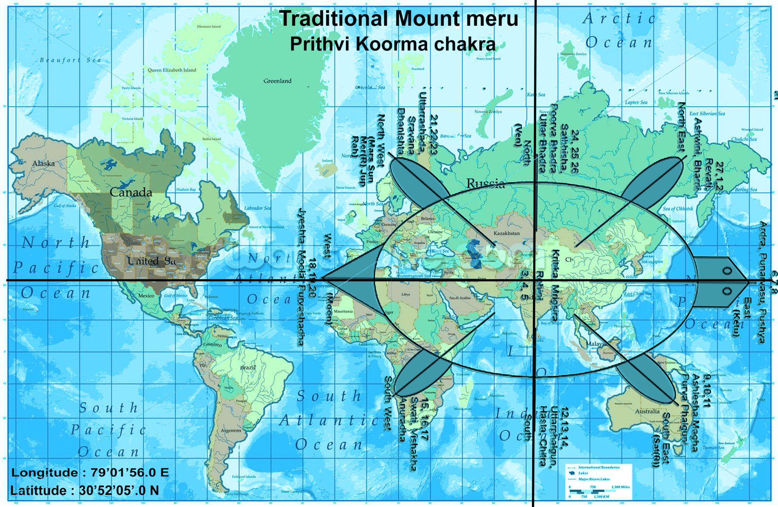
As per Koorma chakra, Taurus is the centre point of the earth, where Rohini Nakshatra is the astrological sign that governs the center of the earth and also the centre point of India as well that we have to take into consideration when we place Koorma chakra over the India Map ( i.e. we can place traditional as well as modern map of India ) , and Vidisha, a place from Madhya-Pradesh, will be considered as the centre point of India, which is located in the middle of India.
An examination of the historical data of Nautapa suggests that there are recurrent trends of extremely high temperatures during this nine-day period in India that occurs before to the monsoon season. The phenomenon known as Nautapa, which literally translates to “nine days of intense heat,” has been seen and documented by us due to the significant impact it has on temperatures, which frequently leads to catastrophic heatwaves.
The historical records indicate that temperatures have consistently surged beyond 40 degrees Celsius (104 degrees Fahrenheit) during the Nautapa period, with particular regions witnessing even higher rises and temperatures.When one considers the highest temperatures that have occurred over the course of the last few decades, it is clear that the intensity of Nautapa has been oscillating.
For instance, during the Nautapa earthquake that occurred in 2010 and 2016, temperature records reached levels that had never been seen before. In some regions, temperatures went as high as 48 degrees Celsius (118.4 degrees Fahrenheit). These kinds of anomalies have drawn attention to the fact that heatwaves in India are becoming more severe, which may be connected to broader climate shifts.
When looking at the length of time that these heatwaves last, historical data reveals that although Nautapa is typically a nine-day occurrence, the effects of these heatwaves frequently last for longer than that period of time. The protracted impact that Nautapa has had on the environment and public health has been highlighted by the fact that findings from post-heatwave study have regularly showed that residual high temperatures and delayed cooling have occurred. The issues that communities are already facing are made even more difficult by these prolonged periods of heat stress, particularly in locations that lack suitable infrastructure for heat mitigation.
In addition, the historical patterns of Nautapa have demonstrated anomalies of a significant nature. In certain years, for instance, the commencement of the heatwave has been delayed, while in other years, the intensity of the heatwave has been surprisingly lower or higher than they would have been otherwise. It is essential for meteorologists to take into consideration variations of this kind when attempting to forecast future trends. The historical data reveals that although the nine-day period continues to be a continuous timeframe, the actual influence can vary greatly depending on the different meteorological circumstances that occur each year with each passing year.
Given the historical backdrop and trends that have been observed, it is reasonable to anticipate that Nautapa will experience excessive heat in 2024 in a manner that is comparable to previous years. The severity and length of the heatwave are likely to be affected by a variety of factors, including but not limited to fluctuations in global temperatures, local meteorological conditions, and anomalies in the atmosphere. Therefore, continuous monitoring and analysis of past data are necessary in order to make accurate predictions and to effectively plan for mitigating the negative consequences of Nautapa.
Heatwaves, Rainfall and Nautapa in 2024 – Mendini Jyotish or Mundane Astrology Analysis of Heatwaves pattern in the year 2024

In accordance with the Mundane or Medini Jyotish Siddhanta concept, the burning heat of the sun causes direct rays to fall on the centre of the earth whenever it transits over the Taurus sign. This is especially true around the Kritika and Rohini nakshatra during the months of April, May, and June, which causes the atmosphere to become hot. This, in turn, produces a condition in which storms and windstorms typically occur during the month of Ashada as a result of the sun’s travel over the Rohini, Mrigshira, and Ardara Nakashtras, which are classified as Prachanda, Vayu, and Soumya Nadi respectively.
The upshot is that heat outbreaks are increasing in most parts of the country, and dust storms and severe heat are disrupting life beginning at the beginning of April.
These events occur during Prachanda and Vayu Nadi, which are recognized for their strong wind movements whenever it is influenced by Saturn, Mars and Nodes. When the sun finally makes its way into the sky, which occurs later on during the Soumya Nadi, the south-western part of India is subjected to a significant amount of precipitation.
Nautapa Analysis of 2024 – Astrologically Explained
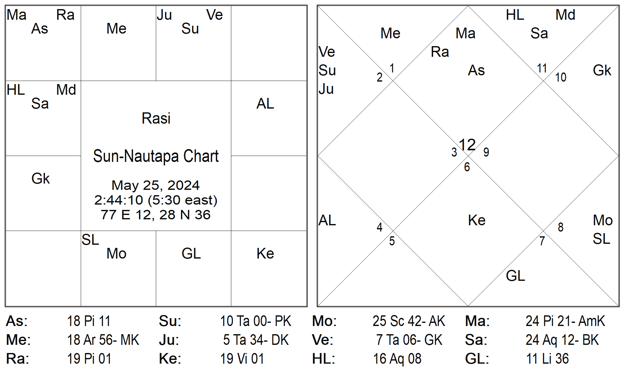
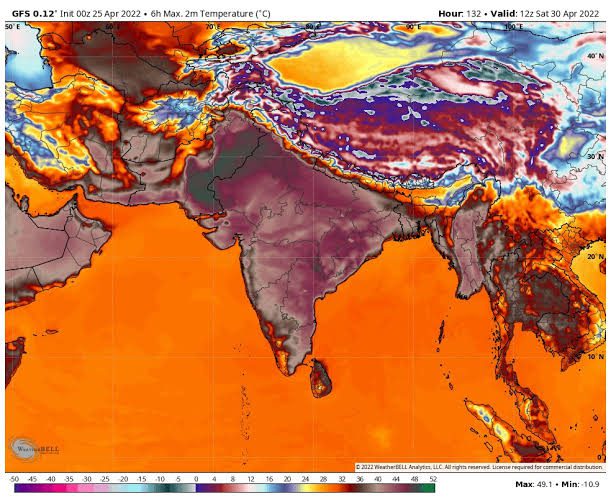
This year, the nine days of blistering heat are expected to begin in the Jyestha month of May and June, beginning on May 25–26, 2024, and continuing forth we may experience sever to sever heatwaves and temperature can cross or touch upto 46-48 degree in majority of the Indian states and in few states it can touch up to 49-50 degree falling in the north western zone of India that is very rare in weather monitoring experiencing.
This is because the sun will be entering the Rohini Nakshatra by this year with other planetary alignment ( i,e Venus & Jupiter both will be in Prachanda Nadi and falling in Kendra to the Saturn ) in close conjunction with Jupiter & Venus on 25th May 2024 around 2:41:11 am at 10:00:02 degree, that shows we experience severe heatwaves in North & Northwestern states of India from 25th Of May to 6th June 2024.
In the Nautapa chart of 2024, both Rahu and Mars are ruling over the ascendent that shows we experience some sort of catastrophic event related to water causalities, flooding or via heavy rainfall in North eastern states most probably after new moon when there will be conjunction of the 5 planets in taurus sign. The signs of Pisces show that this year we may have a have a strange weather pattern with severe heatwaves and a strange rainfall pattern. There will be extreme heatwaves, and we will also experience extreme rainfall.
From now until the 15th of June in 2024, the sun will continue to be in the Rohini Nakshatra for this lunar month when we can continuously experience Severe heatwaves along with higher amount of humidity almost majority of Indian states. Because of its direct link with the atmosphere of the planet, this transit almost always results in weather conditions that are extremely severe specially in terms of heatwave patterns that shows we can have ample amount of rainfall in monsoon season that probably start after Sun transits over Adara Nakshatra in June month . These severe heatwave’s will extreme gives rainfall scenario in the month of July, August and September 2024 due to higher amount of precipitation in the month of May of June.

According to the majority of opinions noted in the Sahimta Shashtra and in classical writings, the term “Rohini Yoga” is used to describe the phenomenon that occurs when the moon travels through the Rohini Nakshatra during the dark half of the lunar month of Ashadha.
In this period, the astronomer or Medini Jyotishi should keep a close eye on the movement of the winds when the moon precisely enters the Rohini nakshatra. This will allow them to determine the rainy season, which spans from the month of Shraavana to the month of Kartika (July to November). Additionally, they should keep a close eye on the weather throughout the day for any unusual activity in the sky, such as meteorites, comets, thunderbolts, mock fires, and other phenomena that have the potential to disrupt the beginning of the South Western Monsoon pattern. There will be a significant amount of precipitation during the upcoming monsoon season if the sky is clear, hot, and humid. This is something that we can be assured of.
As soon as the sun moves into the Rohini Nakshatra, its rays will have an immediate impact on the majority of the places on the planet, notably from the middle to the northern regions of India and in the centre world.
Due to the greatest planetary alignment, which will have a larger impact on one side of the earth sphere during this movement, they will have a higher impact on the earth, particularly on one side of the place. This increase in impact will be especially noticeable on one side of the place. In addition to this, the sun and moon will be moving in a direction that is very close to the surface of the planet. As the sun and moon make their way towards Rohini Nakashtra, the first nine days of their journey will bring intense heat and warm weather. This will help in the formation of strong clouds for the upcoming monsoon, which will last for two to three months (from June to November) and have an effect on both the southwest and southeast monsoons.
In this particular instance, the sun will enter Rohini Nakshatra on May 25, 2024, in the afternoon. Its influence will continue until June 3, nine days later, as soon as the moon begins to move in the Rohini Nakshatra and the process of garbhadharan begins. The nine nights or days that occur when the sun is at its closest proximity to the earth are referred to as the hottest days of the year. These days are responsible for the extreme heat and warm weather that occurs in practically all of India’s states as well as in other nations. These phenomena have an effect on the monsoon pattern that occurs from June to September.
These nine days of Nautapa are comparable to nine days of the pregnancy of clouds. The more heat that is generated as a result of the movement of the sun and moon over Rohini Nakshatra, the more it is able to carry clouds that cause rain for the upcoming monsoon seasons.
These nine days, which are commonly referred to as the monsoon pregnant clouds, are borne by Mother Earth for the sake of humanity. The sun’s intense heat in the Jala Tattva of Rohini Nakashtras (Rohini is actually a star called Aldebaran, the bull’s eye; Aldebaran is almost 44 times the diameter of the sun) speeds up the condensation cycle in the coastal regions, which ultimately results in the Garabhdharan period of the monsoon. In this year, the Nau-Tapa process starts when the sun enters Rohini Nakshatra on the 25th of May at 10 degrees 00’40’ and continues until the 3rd of June 2024. This position is occupied by the sun until then.
In the course of this time period, the sun, which is a representation of grandeur and ferocious heat, enters the constellation Rohini of the moon and completely absorbs its power. In turn, this causes the elements of fire and water that make up the earth to launch a regeneration process for crops, plants, forests, animals, and rivers, which ultimately results in the natural world being brought back into balance. As a consequence of this, we often experience a large increase in the temperature.
As a result of the increase in temperature during this time period, storms are likely to begin in the upcoming Ashad month (beginning on the 23rd of June 2024 and continuing until the 21st of July), and later in the Ashadha month, when the sun will enter the Cancer sign around the 16th of July along with Venus and Mercury, there will be a significant amount of rainfall that falls in the North, Western, and South Eastern regions.
Additionally, when the beginning of the Sharavana month occurs around the 22nd of July 2024, there is a greater likelihood of storms occurring. As soon as the Sun will join Venus, Mercury, and the Sun in the sign of Leo after the 16th of August 2024, it will be in opposition to Saturn, which is in retrograde motion.
Additionally, there will be a maximum number of planets placed in the fixed sign during that time, which indicates that there will be a possibility of heatwaves, dry winds, and rainfall in certain regions of the world and in coastal regions of India. This will provide us with the opportunity to witness the maximum impact of solar winds and rainstorms on the earth, as well as windstorms in coastal regions of India.
In many states, the arrival of the monsoon season is delayed, which may cause weather anomalies to occur between the months of August and September. As of the 23rd of August, when Venus, Mercury, and the Sun align with South Node Ketu in the sign of Virgo, these anomalies have the potential to bring about unpredictable rains and situations similar to flooding. It is possible for this alignment to take place in the coastal parts of southern India, such as Tamil Nadu, as well as in the higher regions of northern India, such as Jammu & Kashmir, Ladakh, and Uttarakhand. This circumstance arises beginning on the 23rd of August, when Venus, Mercury, and the Sun will connect in the sign of Virgo with the South node Ketu.
This may take place in the coastal districts of southern India (Tamilnadu, for example) as well as in the higher regions of north India, such as Jammu, Kashmir, Ladakh, and Uttarakhand. As a result of delayed rainfall brought on by planetary alignments that take place throughout the months of August and September, this circumstance will continue to exist beginning on the 23rd of August and continuing until the end of September 2024.
These meteorological anomalies have the potential to cause substantial harm in the southwestern and north eastern regions of India, particularly through the occurrence of cyclones, floods, or damage to the areas along the coast from 18th to 25th of May 2024..
Impact of Nautapa on Indian Monsoon Pattern in 2024 – Heatwaves and Rainfalls goes back to back
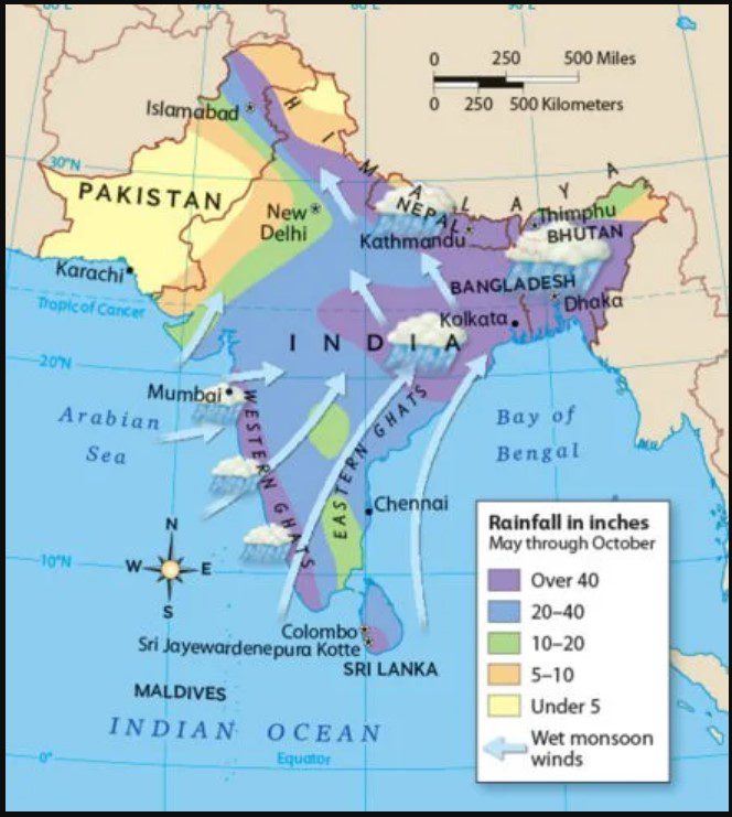
Image Courtesy : PMS -IAS
Now lets understand how exactly Nautapa effects our pre-monsoon pattern. Technically Speaking, Nautapa is a result of the solar and lunar motions that occur during these nine days during the lunar month of Jyestha over Rohini Nakshatra (which, according to the Georgian calendar, finishes in May and begins in June).
The commencement of Nautapa takes place in the Rohini Nakshatras region and continues for a period of nine days unless and until it fully grabs ample of heat, moisture and atmospheric pressure in it that helps to fastens the condensation process in the coastal regions of India .
To understand the pattern of the South West monsoon we need to first understand Garbo-Dharan process of the clouds that starts during these 9 days. This Nau-Tapa, is a meteorological event, which has a tremendous impact on a global scale, normally begins on May 25 and continues until June 2nd or 3rd of each year because of the solar and lunar motion over Rohini Nakshatra.
With regard to the conditions of the South Western monsoon, it has the most severe impact. It is still not known what caused the weather at Nautapa to be so significantly warmer than usual but scientifically speaking it indicates more about the Garbo-Dharan process of the clouds that helps to give clue of south west monsoon winds pattern from South west coastal regions toward Central to, North Eastern and North Indian region.
Importance of Wind Movement during Garbhodharan, Nautapa and Pre-Monsoon 2024

Decoding Vayu-Dharan Process ( Pregnancy of Clouds ) for Monsoon situation of 2024

Below are the points required for Mundane analysis of rainfall, please note it down and carefully follow those.


Vayu-Dharan Process of 2024 – Predicting Rainfalls, South-west Monsoon Pattern in India 2024

This year, the #Vayu Dharan process will start from ”June 6th, 2024, onward when the moon will enter Jyestha Nakashtra, and there will be the beginning of Jyestha month via Jyestha Amavasya. During that, the sun will be in Taurus Sign in Rohini Nakashtra, and those 8 light half days will start from “6th of June to 13th/14th of June 2024 (from Pratipada to Ashthami Tithi) “.
This shift, which is marked by Nautapa, is extremely important because it bridges the gap between the dry and scorching summer season and the monsoon season, which is eagerly anticipated. The understanding of Nautapa and the ramifications it has can provide extremely helpful insights into the patterns of climate and the planning of agricultural production. This age-old idea maintains important importance even in contemporary times, particularly in the context of climate change and its impact on regional weather phenomena, as we delve deeper into the meteorological elements that influenced Nautapa. This becomes apparent as we continue to investigate the factors that contributed to Nautapa.
An annual meteorological phenomena that is known as Nautapa, which translates to ‘nine days of heat’ in Hindi, takes place in some regions of India during the pre-monsoon season. The formation of Nautapa, which in turn adds to the extreme heatwave that occurred during this time period, is closely linked to a number of meteorological circumstances and atmospheric events.
The development of high-pressure systems over the Indian subcontinent is one of the key elements that has contributed to this situation. As a result of these systems, which are characterised by falling air, clouds and precipitation are prevented from forming, which results in bright skies and unending sunshine.
This heat is made more worse by the fact that there is not enough moisture in the air. When Nautapa is over, the air is normally dry, and the humidity levels are rather low. Because of this dryness, evaporative processes are unable to cool down, which leads to significantly greater surface temperatures. Because of the low moisture content, both the land and the air are able to heat up at a faster rate, which in turn makes the heatwave conditions even more severe.
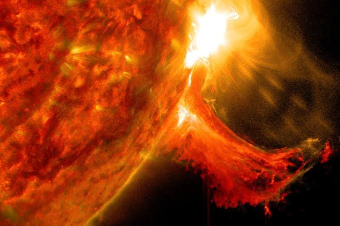
Position of the sun in relation to the Earth is another important factor that played a significant role in the formation of Nautapa. Particularly in the tropical regions of India, the sun is virtually directly overhead during the latter part of May and the beginning of June to a certain extent. The position of the sun at its zenith ensures that the electromagnetic radiation that is received by the surface of the Earth is at its highest possible strength.
Process of Garbo-Dharana and South West Monsoon pattern in India -2024

The monsoon winds that extend beyond south Kerala advance in the shape of two branches, namely the Arabian Sea branch and the Bay of Bengal branch. The Arabian Sea branch progressively extends in a northerly direction. The estimated arrival date in Mumbai is June 10th. The Bay of Bengal branch expands swiftly across the majority of Assam. The typical arrival date in Kolkata is June 7th.
The Himalayan barrier redirects the Bay branch in a westerly direction when it reaches the foothills of the Himalayas, resulting in its progression towards the Gangetic plain. The two branches converge, primarily near Delhi, to create a unified stream. Both branches arrive in Delhi about simultaneously. The collective electric current progressively spreads towards the western regions of Uttar Pradesh, Haryana, Punjab, Rajasthan, and ultimately reaches Himachal Pradesh and Kashmir. The monsoon is generally established in most regions of the country by the end of June.
By the middle of July, the monsoon season reaches Kashmir and the rest of the country. Upon reaching Kashmir, the precipitation had largely dissipated. The Arabian Sea branch of the monsoon is considerably more potent than the Bay of Bengal branch due to the following factors: The Arabian Sea surpasses the Bay of Bengal in terms of size, and The entirety of the Arabian Sea current moves into India, but just a portion of the Bay of Bengal current flows into India, with the rest continuing towards Myanmar, Thailand, and Malaysia.
Impact of Global Warming on Nautapa
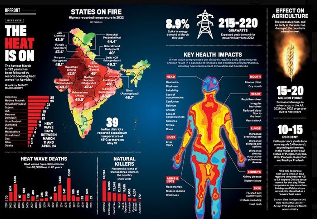
Image Source : India Today | Tanmoy Chakraborty
Both global warming and climate change have a significant impact on the severity and characteristics of Nautapa, which is India’s traditional nine-day heatwave season which occurs every year. Temperatures that are quite high are characteristics of Nautapa. We believe that heatwaves such as the one that occurred in Nautapa will grow more powerful and linger for longer periods of time as the average temperature of the earth continues to rise from previous levels. There are a number of factors that can be ascribed to this occurrence, including greater baseline temperatures and shifting patterns of atmospheric circulation.
According to the findings of a recent study, the frequency and severity of heatwaves in India have dramatically increased as a direct result of global warming. Since pre-industrial times, the average temperature of the entire planet has risen by around 1.2 degrees Celsius, as indicated by studies. Predictions indicate that this trend will continue if there is not a significant reduction in emissions of greenhouse gases over the course of the next few decades. As a result of this increase in temperature, there will be an increase in the number of instances of extreme weather, including heatwaves that continue for an extended period of time.
Alterations to the patterns of the monsoon are one of the most significant factors that are contributing to the intensification of the effects of Nautapa. As a consequence of climate change, the behaviour of the monsoon has grown increasingly irregular and unpredictable. This is because climate change has altered the beginning of pre-monsoon conditions as well as the strength of those conditions. When the monsoon arrives later than expected, heatwaves might last for longer periods of time than they would otherwise. Furthermore, alterations in the patterns of precipitation can have an impact on the levels of humidity, which can make heatwaves even more uncomfortable.
In places with a high population density, the effects of heatwaves are made worse by urbanisation and a phenomena that is referred to as the urban heat island effect. Cities with extensive concrete and asphalt surfaces have a tendency to absorb and keep more heat, which results in higher temperatures. This is in contrast to rural environments, which tend to have a lower capacity for heat absorption and retention. This urban heat island effect, in conjunction with rising global temperatures, has the potential to bring about heatwaves that are more severe and continue for a longer amount of time throughout the Nautapa period.
It is likely that future Nautapa periods will see heat levels that have never been experienced before if the trends that are currently occurring continue. This would provide significant risks to the public’s health, as well as to agricultural and water supply systems. The forecasts made by climate models and predictive models indicate that the current trends will presumably continue. We have an immediate and pressing need to take comprehensive climate action in order to mitigate the effects of global warming and adapt to circumstances that are changing in the environment. If we are going to be successful in overcoming these challenges, we will need to make a concentrated effort on both the national and international levels. The implementation of climate policies that are effective, the adoption of sustainable behaviours, and the use of renewable energy sources should be the primary focus of this effort.
Astro- Meteorological Predictions for 2024
While we are getting closer to the pre-monsoon season of 2024, climatic forecasts show that Nautapa, the infamous nine-day period of high heat, will once again create substantial issues across the entirety of India. The current models and data indicate that the severity of the heatwave will be significantly severe, and it is anticipated that temperatures will rise to levels that are significantly higher than the averages for the season. It is estimated that this heatwave will last for a period of nine days, during which time temperatures are expected to reach levels that have never been seen before. This duration is consistent with the trends that have been observed in the past.
Detailed projections have been offered by experts from renowned meteorological institutes, such as the India Meteorological Department (IMD) and the National Centre for Medium Range Weather Forecasting (NCMRWF). These forecasts are based on advanced climate models. The projections that have been made shed light on the geographical impact that Nautapa will have, with the northern and central regions of India being the ones that are expected to experience the most severe temperatures. There is a high probability that cities such as Delhi, Jaipur, and Nagpur may see extreme heat conditions, capable of potentially surpassing records that have been observed in past years.
A senior meteorologist at the Indian Meteorological Department named Dr. Ramesh Kumar highlighted the fact that the combination of high-pressure systems and delayed monsoon onset is anticipated to make the severity of the heatwave even worse. “This year, we are observing stronger-than-usual high-pressure systems that trap heat and prevent cloud formation, leading to prolonged periods of intense heat,” according to the scientist. The urgent need for adaptive measures in response to rising global temperatures is brought to light by the fact that experts are warning that larger climatic changes could be the cause of the growing frequency and intensity of heatwaves.
Taking into consideration these forecasts, it is of the utmost importance for communities and local authorities to make preparations for the imminent heatwave. In order to mitigate the negative impacts of Nautapa, it will be particularly important to establish cooling centres, make certain that there is an appropriate supply of water, and educate the general population about the dangers of heat-related illnesses. These preparatory measures will be guided by the data-driven insights offered by meteorological institutions, which will play a crucial role in guiding these efforts and helping to protect public health and infrastructure during this period of extreme heat.
Impact on Agriculture and Water Resources
The 2024 Nautapa heatwave poses significant challenges to agriculture and water resources in India. Extreme heat during this period can severely affect crop yields, soil moisture, and water availability, thereby threatening food security and livelihoods in agrarian communities. The high temperatures accelerate the rate of evapotranspiration, leading to reduced soil moisture levels and increased water stress for crops.
One of the primary concerns is the impact on crop yields. Crops such as wheat, rice, and maize are particularly vulnerable to heat stress during their critical growth stages. Prolonged exposure to temperatures above the optimal range can lead to reduced grain filling, lower biomass accumulation, and ultimately, decreased yields. Moreover, the heatwave can exacerbate pest and disease outbreaks, further compromising crop health and productivity.
Soil moisture depletion is another critical issue. The extreme heat can cause rapid evaporation of water from the soil, leading to dry and arid conditions. This not only affects the current crop cycle but also has long-term implications for soil health and fertility. Farmers may face difficulties in maintaining adequate soil moisture levels, making it challenging to ensure the successful germination and growth of crops.
Water availability is also a significant concern during the Nautapa heatwave. The increased demand for irrigation water, coupled with the reduced availability of water resources, can lead to conflicts over water use. Rivers, reservoirs, and groundwater sources may experience significant depletion, impacting not only agriculture but also drinking water supplies for communities.
In response to these challenges, farmers and communities are adopting several strategies to mitigate the impacts of extreme heat. These include the use of drought-resistant crop varieties, efficient irrigation practices such as drip and sprinkler systems, and the implementation of soil moisture conservation techniques like mulching. Additionally, rainwater harvesting and the use of weather forecasting tools can help farmers make informed decisions about planting and irrigation schedules.
Overall, while the 2024 Nautapa heatwave presents considerable risks to agriculture and water resources, proactive measures and adaptive strategies can help mitigate its adverse effects, ensuring the resilience and sustainability of India’s agricultural sector.
Health Risks and Safety Measures
Extreme heatwaves, such as the Nautapa’s 9-day event, pose significant health risks to the population. One of the most severe conditions associated with heatwaves is heatstroke, a life-threatening situation where the body’s temperature regulation fails. Symptoms include confusion, seizures, and loss of consciousness, necessitating immediate medical attention. Additionally, dehydration is a common consequence of prolonged exposure to high temperatures, leading to symptoms like dizziness, dry mouth, and decreased urine output. It is crucial to maintain adequate hydration by drinking plenty of fluids, even if not thirsty.
Heatwaves can also exacerbate chronic illnesses, particularly cardiovascular and respiratory conditions. Individuals with pre-existing health issues should take extra precautions, such as staying indoors during peak heat hours and ensuring they have access to necessary medications and medical care. Vulnerable populations, including the elderly, children, and those with chronic health conditions, are especially at risk and require vigilant monitoring.
To mitigate these risks, several safety measures are recommended. First and foremost, staying hydrated is essential. Water should be consumed regularly, and beverages that can lead to further dehydration, such as alcohol and caffeinated drinks, should be avoided. Wearing lightweight, loose-fitting clothing helps in maintaining body temperature, while hats and sunglasses offer protection against direct sunlight. Staying indoors, especially during the hottest parts of the day, and using fans or air conditioning can significantly reduce heat exposure.
Communities can play a pivotal role in safeguarding their members. Establishing cooling centers and ensuring they are accessible to the most vulnerable can provide much-needed relief. Public awareness campaigns by health professionals and emergency services are crucial in disseminating information on recognizing the signs of heat-related illnesses and the importance of staying cool and hydrated. Simple measures like checking on neighbors, especially the elderly or those living alone, can make a significant difference in community resilience against extreme heatwaves.
Conclusion and Future Outlook
As we have explored, the Nautapa period brings about a significant and challenging weather phenomenon characterized by extreme heatwaves in India. Understanding the meteorological factors behind these nine days of intense heat is crucial for preparedness and resilience. Throughout this blog post, we delved into the atmospheric conditions, historical data, and implications of Nautapa, highlighting how these extreme temperatures impact both the environment and the population.
The increasing intensity of heatwaves, exacerbated by climate change, underscores the need for ongoing research and adaptation strategies. Meteorological studies and data analysis are essential in predicting and preparing for such events. It is imperative for scientists, policymakers, and the public to work collaboratively to develop effective strategies to mitigate the adverse effects of these extreme weather conditions. This includes advancing early warning systems, improving infrastructure to withstand extreme heat, and promoting public awareness about heatwave preparedness.
Technological advancements hold promise in addressing these challenges. Innovations in climate modeling and forecasting can lead to more accurate predictions, allowing for timely interventions. Similarly, urban planning and building designs that incorporate heat-resistant materials and green spaces can help reduce the urban heat island effect, providing some relief during intense heatwaves. Additionally, policy measures aimed at reducing greenhouse gas emissions and promoting sustainable practices can play a pivotal role in mitigating the long-term impacts of climate change.
In conclusion, while the threat of increasingly severe heatwaves due to climate change is a daunting challenge, it is one that can be met with concerted efforts and innovative solutions. By leveraging technology, enhancing research, and implementing robust policies, we can build a more resilient future capable of withstanding the rigors of extreme weather events like Nautapa. Through proactive measures and global cooperation, it is possible to mitigate the impacts and protect communities from the harsh realities of extreme heat.
With Thanks and Regards,
Rocky Jamwal
Source, Reference and Links
[1]. Weather and Earthquake by B.V Raman
[2]. Brihat Samhita by Varahmihira, Commentry by Dr Ramakrishna bhatt
[3]. Internet for various Data, Images and research.

Views: 228