Exploring Astro-meteorological Analysis of Nautapa and Extreme heatwave patterns in India and the world for the monsoon condition of 2024
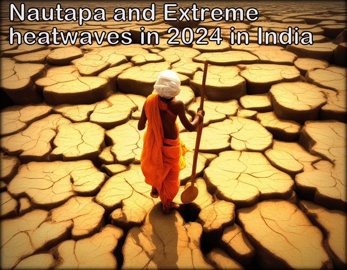
Nautapa year 2024 heatwaves vedicsiddhanta Exploring Astro-meteorological Analysis of Nautapa and Extreme heatwave patterns in India and the world for the monsoon condition of 2024


What is Nautapa ?

Nautapa in mundane astrology , is a traditional nine-day period of extreme heat in India, occurs during the pre-monsoon season and significantly impacts agriculture, water resources, and public health. This blog post delves into the meteorological factors behind Nautapa, historical data, and the influence of global warming on its intensity. Learn about predictions for Nautapa 2024 and discover strategies to mitigate its adverse effects on communities and the environment.

Introduction to Nautapa

This ancient Indian meteorological term, which is derived from the Sanskrit words ‘nau’ meaning nine and ‘tapa’ meaning heat, refers to a period of nine days during which the temperature is extremely high. The occurrence of this phenomena, which is firmly established in India’s cultural and agricultural fabric, typically takes place in the latter half of May or the beginning of June. The Nautapa is a key landmark on the agricultural calendar, signalling the imminent approach of the monsoon season. Nautapa is more than just a meteorological occurrence; it is also a significant marker.

These nine days see temperatures climb to their highest point of the year, which is typically reached over these nine days. Because it has an impact on both natural processes and human activity, this time period is noteworthy from a historical perspective. The farmers, in particular, keep a careful eye on Nautapa because they believe it will have an effect on the quality of the monsoon rains that are on the way. It is believed that the severe heat creates conditions that are favourable for the formation of monsoon winds, which are crucial for the existence of the country’s agricultural sector.

The cultural significance of Nautapa is represented by a number of different local traditions and folklore. There are a variety of activities and rituals that are carried out in various regions of India with the purpose of appeasing the deities and seeking relief from the heat. In addition, the cyclical nature of weather patterns, which is firmly embedded in the ancient knowledge systems that have been passed down from generation to generation, serves as a reminder during this time period.

As a consequence of this, the ground is able to take in and hold onto more heat, which is a contributing factor to the rising temperatures. The interaction between these high-pressure systems, dry air conditions, and the sun’s zenithal position results in a one-of-a-kind set of circumstances that leads to the intense heat that was witnessed during the Nautapa period. In addition, there are no substantial weather systems that could provide cooling showers or winds, which means that there is very little that can be done to alleviate the excessive heat. In order to effectively predict and prepare for Nautapa, it is essential to have a solid understanding of these climatic conditions. This will allow for improved preparedness and adaption measures to deal with the high temperatures that are expected to be experienced.

Summary of the Article : Weather Forecast in 2024 and impact of Nautapa

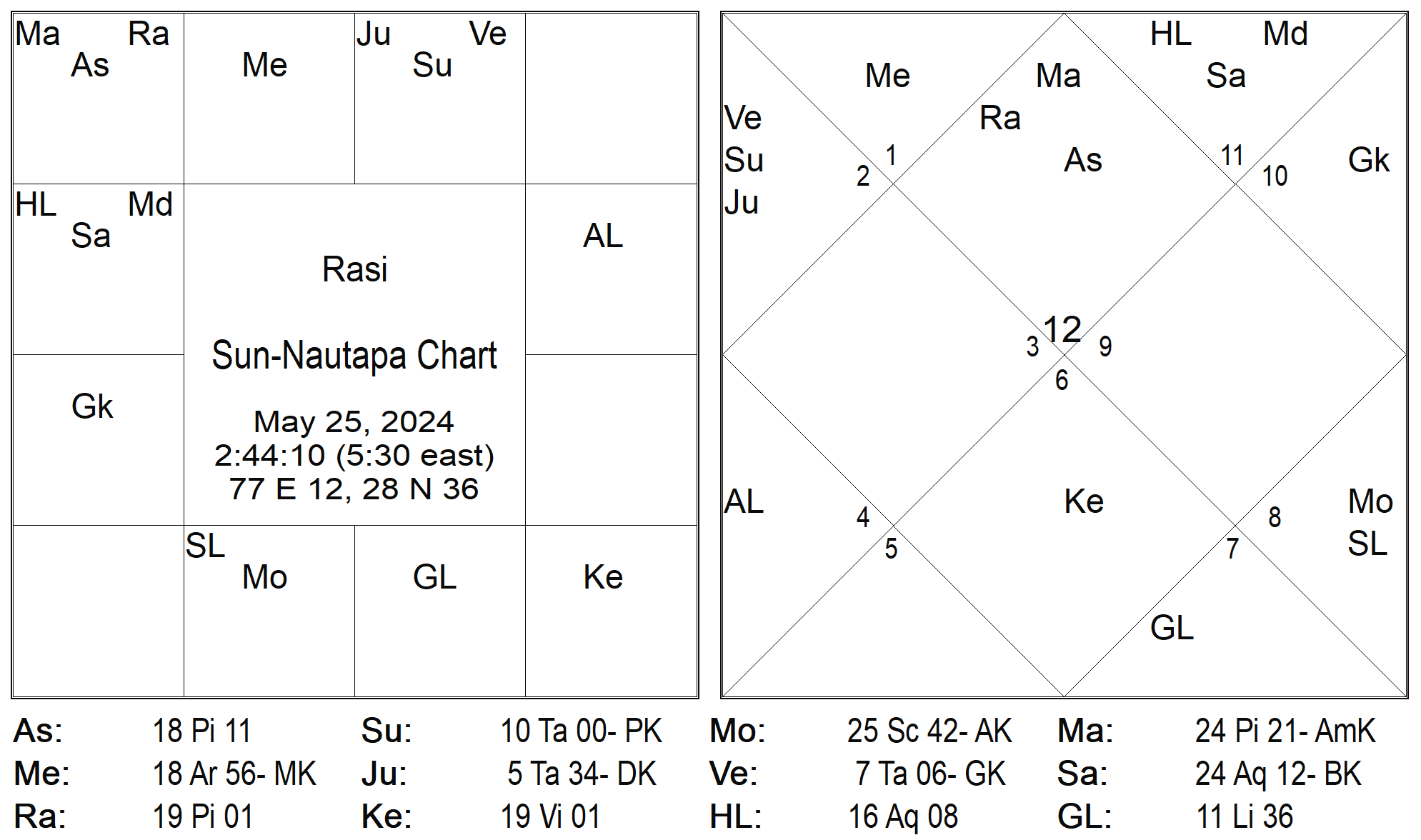
This year, India is expected to experience nine days of extreme heatwaves in the Jyestha month of May and June, with temperatures reaching 46-48 degrees in most Indian states. The sun will enter the Rohini Nakshatra, with Venus and Jupiter in close conjunction with Jupiter and Venus, causing severe heatwaves in the North and Northwestern states from May 25th to June 6th 2024. The Nautapa chart indicates potential catastrophic events related to water causalities, flooding, or heavy rainfall in the north & North east of india. The signs of Pisces suggest a strange weather pattern with extreme heatwaves and rainfall. From June 15th, the sun will remain in the Rohini Nakshatra, causing severe heatwaves and higher humidity in most Indian states. Astronomers should monitor the movement of winds during this period to determine the rainy season and watch for unusual sky activity, such as meteorites, comets, thunderbolts, and mock fires, which could disrupt the South Western Monsoon pattern.

The sun and moon will move into the Rohini Nakshatra on May 25, 2024, causing intense heat and warm weather that will affect most parts of the planet, particularly in India and the center world. This movement will result in the formation of strong clouds for the upcoming monsoon, which will last for two to three months from June to November. The nine days of Nautapa, or the pregnancy of clouds, are responsible for extreme heat and warm weather in India and other nations.

The sun’s intense heat in the Jala Tattva of Rohini Nakashtras accelerates the condensation cycle in coastal regions, leading to the Garabhdharan period of the monsoon. The Nau-Tapa process starts when the sun enters Rohini Nakshatra on May 25th and continues until June 3rd, 2024. The sun’s intense heat absorbs its power, causing the elements of fire and water to regenerate for crops, plants, forests, animals, and rivers, resulting in a large increase in temperature.

Storms are likely to begin in the Ashad month (June 23rd to July 21st) and continue until the 16th of July when the sun enters the Cancer sign with Venus and Mercury, causing significant rainfall in North, Western, and South Eastern regions. The Sharavana month begins on July 22nd, 2024, with a greater likelihood of storms.

Monsoon season arrival may be delayed in many states, leading to weather anomalies between August and September. These anomalies can cause unpredictable rains and flooding, particularly in coastal areas of southern India and northern regions like Jammu & Kashmir, Ladakh, and Uttarakhand.

Mundane Astrological Understanding of Nautapa based on Astro-Meteorology of 2024
 

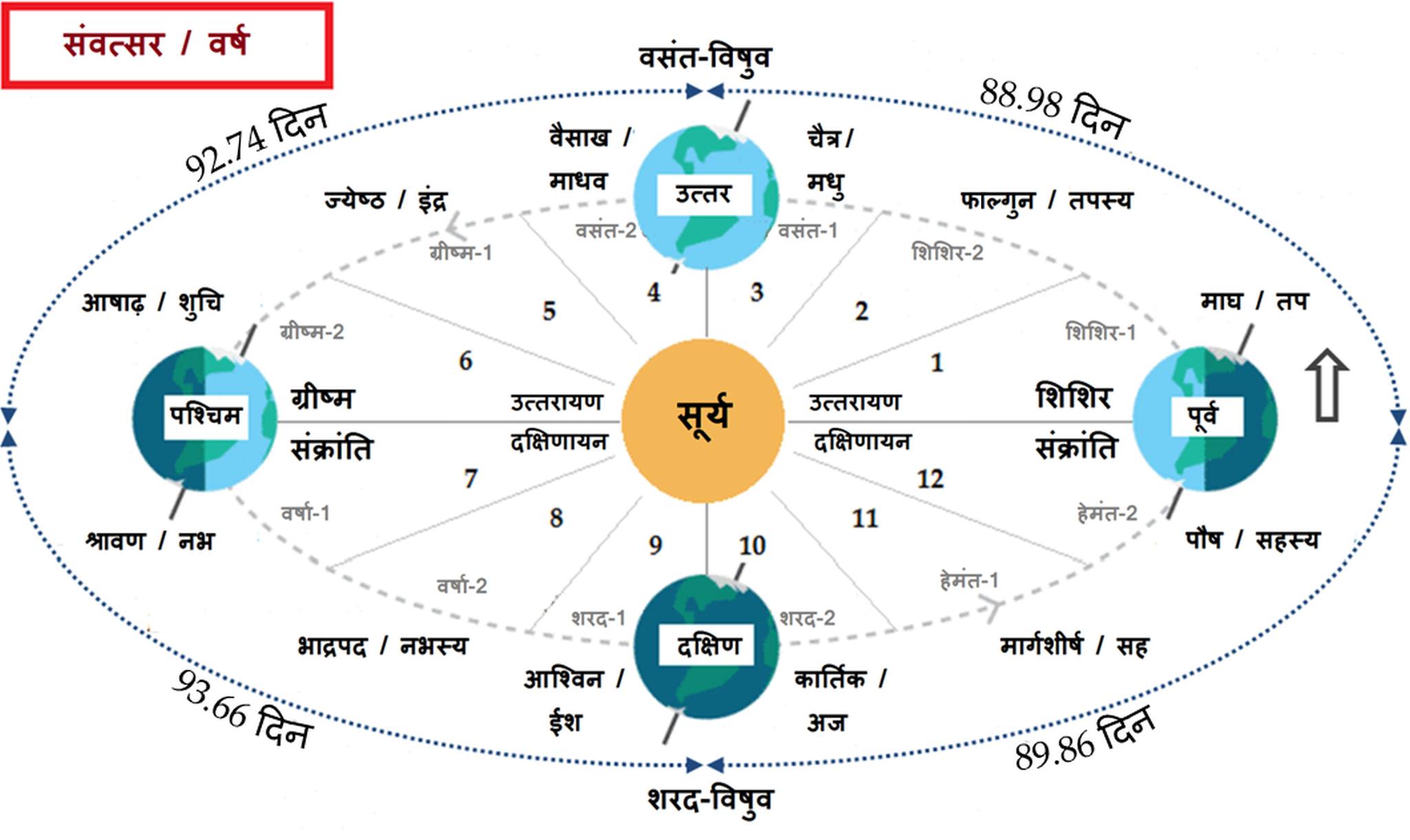
Koorma Chakra scaled Exploring Astro-meteorological Analysis of Nautapa and Extreme heatwave patterns in India and the world for the monsoon condition of 2024


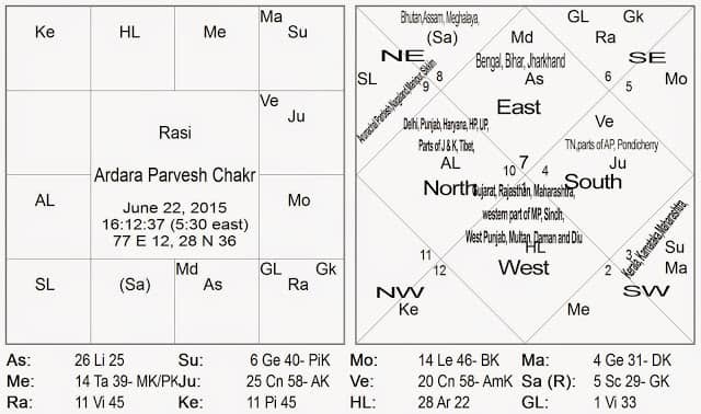
In astro metrology, the role of the Sun and Mars has a bigger role in analysing the heatwave patterns during pre-monsoon and monsoon seasons, i.e., if both the Sun and Mars are closely conjugated or have close relations in the same house in Ardara Parvesh chakra, it usually gives intense dry and warm weather for that year, and there will be intense heat waves before the start of monsoon. If, in the same case, the sun is behind Mars, then there will be the possibility of no rain for the whole monsoon season. There are numerous combinations that play a significant role in analyzing heat wave patterns during the Jyestha and Shravan months of May, June, and July.

  1. When both the sun and Saturn align closely in a single rashi, we typically witness intense heat waves during summer, and during winter, we typically experience severe cold and copious snowfall. According to common practices, Saturn is associated with dry and cold winds, typically causing dryness and severe coldness in the atmosphere based on seasonal fluctuations. When it aligns with Jala Nadi, it typically results in Strong windstorms of water and air and storms can cause massive cyclones in coastal regions, and wrecking of ships via thunderstorms is a role of Mars when it is with Saturn or getting aspects from Mars in coastal areas. When Saturn is in an airy nadi, it typically drives away all the rain-causing clouds with its powerful wind and dryness.
  2. If Saturn is in Agni Nadi, it usually gives intense dry heat waves, dusty wind storms, and heavy storms, which are very powerful and can even break any buildings or obstacles in their paths.
  3. If there are more planets in Agni Nadi, i.e., the Sun, Mars, Jupiter, and Saturn, it will also have strong heatwave patterns.

Our sages use the Sapta nadi Chakra, an ancient chakra scheme, to decipher and analyze summer, monsoon, and heatwave patterns. They use it to predict weather, floods, thunderstorms, and heat wave patterns, particularly for rainfall. It is the most effective tool for forecasting monsoon activities in India, particularly those related to the sun’s movement in Ardara Nakashtra.

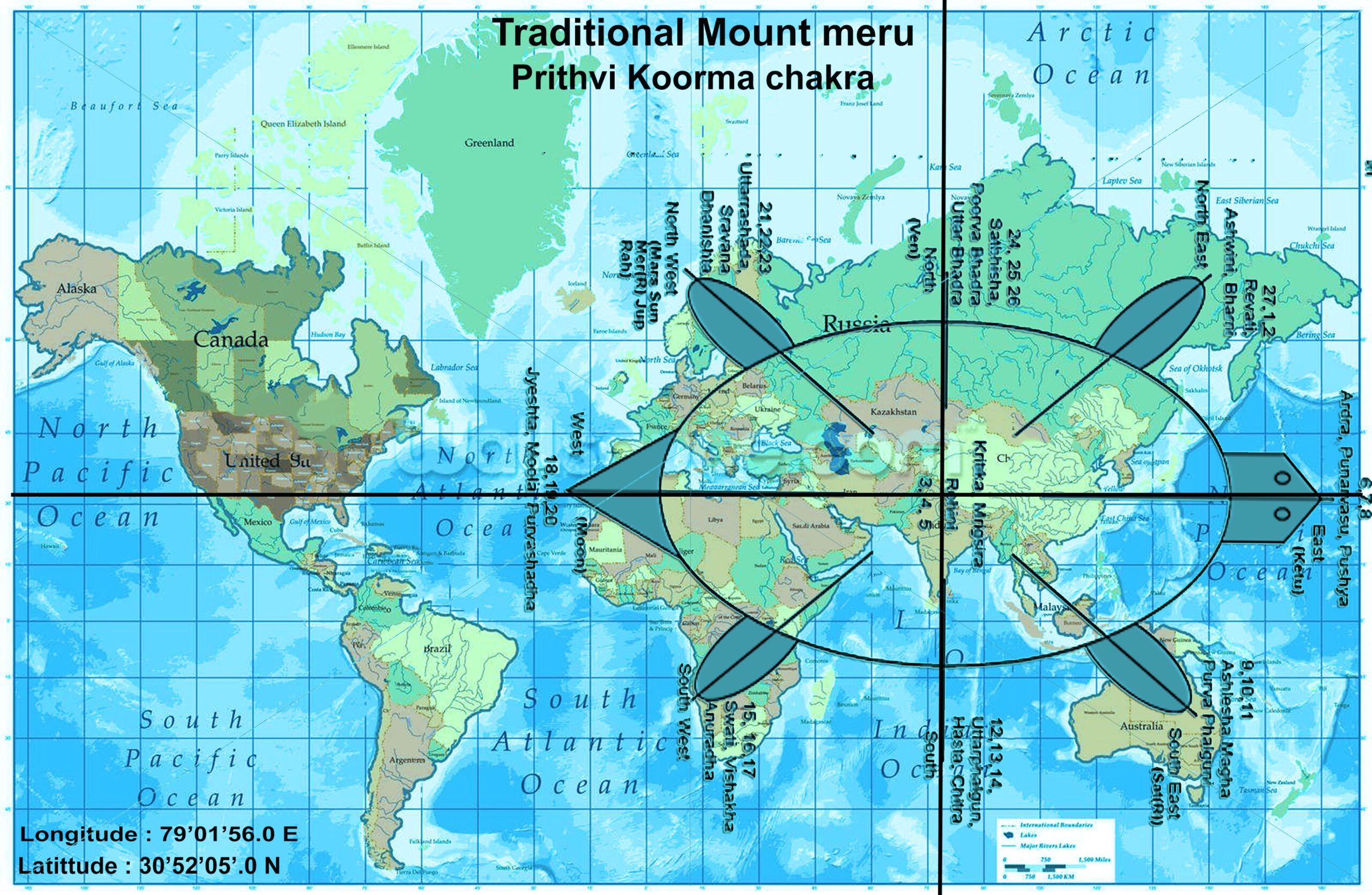
Although it can also be used for global rain patterns, it requires extensive work with Koorma Chakra to locate Nakashtras on world charts using Videsh Koorma Chakra. Two ancient sources of Saptanadi Chakra, Narapati Jayachara and Sage Parashara, widely explain Sapta Nadi Chakara, and serve as the foundation for all subsequent texts. The original source of Sapta nadi Chakra was a tantric text titled ‘yamaleeya-Svarodaya’.

  1. Narapati Jayachara explains that it calculates the amount of rainfall starting from Kritika Nakashtra. The Sapata Nadi Chakara system widely uses the 4 Nakashtras Scheme. Saturn rules Parachanda Nadi (Chanda Nadi), which categorizes “Kritika, Vishakha, Anuradha, and Bharni Nakashtra”.
  2. The “Rohini, Jyestha, Swati, and Ashwani” nakashtras are located in Vayu Nadi, under the influence of the Sun. Mars rules “Mrigshara, Chitra, Moola, and Revti” in Agni Nadi. “Ardara, Hasta, Poorva Ashadha, and Uttrabhadra” fall in Soumya Nadi, which is ruled by Jupiter.
  3. “Punurvasu,” “Uttraphalguni,” “Uttra Ashada,” and “Poorva Bhadra” fall in Neera Nadi, ruled by Venus. “Pushya, Poorva Phalguni, Abhijeeta, and Satabhishaq”  fall in Jala Nadi, ruled by Mercury. “Ashlesha, Magha, Sharvana, and Dhanistha”  fall in Amrita Nadi, ruled by the Moon. 
  4. Prachanda Nadi usually gives a huge blow of wind; Vayu Nadi gives a normal volume of wind; and Agni Nadi gives immense heat and warm weather. Neera Nadi usually gives clues to cloud entry, and Jala and Parachanda planets give heavy rainfall. When the Malefic, Moon, and Beneficial planets align in the same sign or nakashtra, it typically results in an abundance of rainfall.
  5. When a moon and a planet conjugate in the same nakashtra on the same day, heavy rainfall occurs for 2.5 days until the moon aligns with that planet. When both Malefic and Benefic planets align with the moon in Amrita Nadi, the rain typically lasts for 3, 4, or even up to 7 days. In Jala Nadi, if the moon is both malefic and benign, it can also give rain for up to 1.5 or 5 days. 
  6. When the Moon, Mars, and Jupiter align closely in any nadi, it has the potential to submerge the entire earth for several days. During planet direct motion, retrograde motion, and combustion, and during any planet movement in sankranti in Jala Nadi, it usually gives excessive rainfall for a few days. When Mars moves ahead of the sun, it can absorb all heavy rain-producing clouds, resulting in a period of warm weather without rain.
  7. Mars and the sun usually produce excessive heat waves, warm weather, and the possibility of high humidity. For making a Sapta nadi Chakara, we need to use the 28 Nakshatra scheme. We also allot a space towards the end of Uttarashada for the 28th Nakshatra, ‘Abhijit’.
  8. Starting from ‘Krittika’ (3rd Nakshatra), we divide these Nakshatras into 7 Nadis, which include ‘Vaat Nadi or Airy Nadi’, ‘Ati-vaat or Prachand Nadi’, ‘Dahan’, ‘Soumya’, ‘Neera’, ‘Jala’, and ‘Amrita’. Usually Vaat produces windy weather, Ati-vaat produces cold weather after rainstorms, Dahan increases temperature depending on the environment, as Dahan Nadi is very sensitive to nature and surroundings and gradually increases with time and environment, and Soumya, Neera, Jala, and Amrita Nadis are rain-producing Nadis. 
  9. If we observe any unnatural activity in the Saptanadi chakra, we can verify it using the “Casting Hindu Near Year Chart for India”, which is based on the sun’s arrival on “Chaitra Shukala partipat tithi”.

To precisely decipher heatwave patterns during any summer season, we can examine the placement and planetary alignment during the Nautapa phase in various nakashtras and the Medini Nadi system. The Sun rules over Rohini, the most significant nakashtra during Nautapa, which falls under the Vayu Nadi category. This shows how exactly the heatwave pattern will be during any summer season and shows the exact condition of the pregnancy of the clouds due to exceptionally aggressive heat, humidity, warm weather, and wind flow in the Nautapa, as its nakashtra role falls under Vayu nadi, which shows how wind movement can help in precipitation. This phase is characterised by more aggressive heat and warm weather, and we can observe a rise in both temperature and humidity. More heat and warm weather mean more, and we expect plenty of rainfall after this in June and July. If the Nautapa phase continues, we can experience heavy to heavy rainfall in Ardra Parvesh when the sun enters the Ardara Nakashtra during the south-west monsoon.

The term here “Nautapa” in the Rohini Nakshatra refers to a nine-day period during which the sun’s movement in the Rohini Nakshatra induces severe heat following Kritika and Bharini Nakashra while also controls Eastern and Central Indian region as well, Majorly effects March and April month whenever we having Strong agni Graha ( i.e Mars, Sun etc )  influences on the Kritika, Bahrani and Rohini Nakshatra.

As per Koorma chakra, Taurus is the centre point of the earth, where Rohini Nakshatra is the astrological sign that governs the center of the earth and also the centre point of India  as well that we have to take into consideration when we place Koorma chakra over the India Map ( i.e. we can place traditional as well as modern map of India ) , and Vidisha, a place from Madhya-Pradesh, will be considered as  the centre point of India, which is located in the middle of India. 

An examination of the historical data of Nautapa suggests that there are recurrent trends of extremely high temperatures during this nine-day period in India that occurs before to the monsoon season. The phenomenon known as Nautapa, which literally translates to “nine days of intense heat,” has been seen and documented by us due to the significant impact it has on temperatures, which frequently leads to catastrophic heatwaves.

The historical records indicate that temperatures have consistently surged beyond 40 degrees Celsius (104 degrees Fahrenheit) during the Nautapa period, with particular regions witnessing even higher rises and temperatures.When one considers the highest temperatures that have occurred over the course of the last few decades, it is clear that the intensity of Nautapa has been oscillating.

For instance, during the Nautapa earthquake that occurred in 2010 and 2016, temperature records reached levels that had never been seen before. In some regions, temperatures went as high as 48 degrees Celsius (118.4 degrees Fahrenheit). These kinds of anomalies have drawn attention to the fact that heatwaves in India are becoming more severe, which may be connected to broader climate shifts.

When looking at the length of time that these heatwaves last, historical data reveals that although Nautapa is typically a nine-day occurrence, the effects of these heatwaves frequently last for longer than that period of time. The protracted impact that Nautapa has had on the environment and public health has been highlighted by the fact that findings from post-heatwave study have regularly showed that residual high temperatures and delayed cooling have occurred. The issues that communities are already facing are made even more difficult by these prolonged periods of heat stress, particularly in locations that lack suitable infrastructure for heat mitigation.

In addition, the historical patterns of Nautapa have demonstrated anomalies of a significant nature. In certain years, for instance, the commencement of the heatwave has been delayed, while in other years, the intensity of the heatwave has been surprisingly lower or higher than they would have been otherwise. It is essential for meteorologists to take into consideration variations of this kind when attempting to forecast future trends. The historical data reveals that although the nine-day period continues to be a continuous timeframe, the actual influence can vary greatly depending on the different meteorological circumstances that occur each year with each passing year.

Given the historical backdrop and trends that have been observed, it is reasonable to anticipate that Nautapa will experience excessive heat in 2024 in a manner that is comparable to previous years. The severity and length of the heatwave are likely to be affected by a variety of factors, including but not limited to fluctuations in global temperatures, local meteorological conditions, and anomalies in the atmosphere. Therefore, continuous monitoring and analysis of past data are necessary in order to make accurate predictions and to effectively plan for mitigating the negative consequences of Nautapa.


Heatwaves,  Rainfall and Nautapa in 2024 – Mendini Jyotish or Mundane Astrology Analysis of  Heatwaves pattern in the year 2024


Nautapa May June 2024 Exploring Astro-meteorological Analysis of Nautapa and Extreme heatwave patterns in India and the world for the monsoon condition of 2024


In accordance with the Mundane or Medini Jyotish Siddhanta concept, the burning heat of the sun causes direct rays to fall on the centre of the earth whenever it transits over the Taurus sign. This is especially true around the Kritika and Rohini nakshatra during the months of April, May, and June, which causes the atmosphere to become hot. This, in turn, produces a condition in which storms and windstorms typically occur during the month of Ashada as a result of the sun’s travel over the Rohini, Mrigshira, and Ardara Nakashtras, which are classified as Prachanda, Vayu, and Soumya Nadi respectively.
The upshot is that heat outbreaks are increasing in most parts of the country, and dust storms and severe heat are disrupting life beginning at the beginning of April.

These events occur during Prachanda and Vayu Nadi, which are recognized for their strong wind movements whenever it is influenced by Saturn, Mars and Nodes. When the sun finally makes its way into the sky, which occurs later on during the Soumya Nadi, the south-western part of India is subjected to a significant amount of precipitation.


Nautapa Analysis of 2024 – Astrologically Explained


Sun Nautapa Exploring Astro-meteorological Analysis of Nautapa and Extreme heatwave patterns in India and the world for the monsoon condition of 2024


This year, the nine days of blistering heat are expected to begin in the Jyestha month of May and June, beginning on May 25–26, 2024, and continuing forth we may experience sever to sever heatwaves and temperature can cross or touch upto 46-48 degree  in majority of the Indian states and in few states it can touch up to 49-50 degree falling in the north western zone of India that is very rare in weather monitoring experiencing.

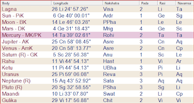
This is because the sun will be entering the Rohini Nakshatra by this year with other planetary alignment ( i,e Venus & Jupiter both will be in Prachanda Nadi  and falling in Kendra to the Saturn )  in close conjunction with Jupiter & Venus on 25th May 2024 around 2:41:11 am at 10:00:02 degree, that shows we experience severe heatwaves in North & Northwestern states of India from 25th Of May to 6th June 2024.   

In the Nautapa chart of 2024, both Rahu and Mars are ruling over the ascendent that shows we experience some sort of catastrophic event related to water causalities, flooding or via  heavy rainfall in North eastern states most probably after new moon when there will be conjunction of the 5 planets in taurus sign. The signs of Pisces show that this year we may have a have a strange weather pattern with severe heatwaves and a strange rainfall pattern. There will be extreme heatwaves, and we will also experience extreme rainfall.

From now until the 15th of June in 2024, the sun will continue to be in the Rohini Nakshatra for this lunar month when we can continuously experience Severe heatwaves along with higher amount of humidity almost majority of Indian states. Because of its direct link with the atmosphere of the planet, this transit almost always results in weather conditions that are extremely severe specially in terms of heatwave patterns that shows we can have ample amount of rainfall in monsoon season that probably start after Sun transits over Adara Nakshatra in June month . These severe heatwave’s will extreme  gives rainfall scenario in the month of July, August and September 2024 due to higher amount of precipitation in the month of May of June. 


kurmachakra Exploring Astro-meteorological Analysis of Nautapa and Extreme heatwave patterns in India and the world for the monsoon condition of 2024


According to the majority of opinions noted in the Sahimta Shashtra and in classical writings, the term “Rohini Yoga” is used to describe the phenomenon that occurs when the moon travels through the Rohini Nakshatra during the dark half of the lunar month of Ashadha.

In this period, the astronomer or Medini Jyotishi should keep a close eye on the movement of the winds when the moon precisely enters the Rohini nakshatra. This will allow them to determine the rainy season, which spans from the month of Shraavana to the month of Kartika (July to November). Additionally, they should keep a close eye on the weather throughout the day for any unusual activity in the sky, such as meteorites, comets, thunderbolts, mock fires, and other phenomena that have the potential to disrupt the beginning of the South Western Monsoon pattern. There will be a significant amount of precipitation during the upcoming monsoon season if the sky is clear, hot, and humid. This is something that we can be assured of.

As soon as the sun moves into the Rohini Nakshatra, its rays will have an immediate impact on the majority of the places on the planet, notably from the middle to the northern regions of India and in the centre world.

Due to the greatest planetary alignment, which will have a larger impact on one side of the earth sphere during this movement, they will have a higher impact on the earth, particularly on one side of the place. This increase in impact will be especially noticeable on one side of the place. In addition to this, the sun and moon will be moving in a direction that is very close to the surface of the planet. As the sun and moon make their way towards Rohini Nakashtra, the first nine days of their journey will bring intense heat and warm weather. This will help in the formation of strong clouds for the upcoming monsoon, which will last for two to three months (from June to November) and have an effect on both the southwest and southeast monsoons.

In this particular instance, the sun will enter Rohini Nakshatra on May 25, 2024, in the afternoon. Its influence will continue until June 3, nine days later, as soon as the moon begins to move in the Rohini Nakshatra and the process of garbhadharan begins. The nine nights or days that occur when the sun is at its closest proximity to the earth are referred to as the hottest days of the year. These days are responsible for the extreme heat and warm weather that occurs in practically all of India’s states as well as in other nations. These phenomena have an effect on the monsoon pattern that occurs from June to September.

These nine days of Nautapa are comparable to nine days of the pregnancy of clouds. The more heat that is generated as a result of the movement of the sun and moon over Rohini Nakshatra, the more it is able to carry clouds that cause rain for the upcoming monsoon seasons.

These nine days, which are commonly referred to as the monsoon pregnant clouds, are borne by Mother Earth for the sake of humanity. The sun’s intense heat in the Jala Tattva of Rohini Nakashtras (Rohini is actually a star called Aldebaran, the bull’s eye; Aldebaran is almost 44 times the diameter of the sun) speeds up the condensation cycle in the coastal regions, which ultimately results in the Garabhdharan period of the monsoon. In this year, the Nau-Tapa process starts when the sun enters Rohini Nakshatra on the 25th of May at 10 degrees 00’40’ and continues until the 3rd of June 2024. This position is occupied by the sun until then.

In the course of this time period, the sun, which is a representation of grandeur and ferocious heat, enters the constellation Rohini of the moon and completely absorbs its power. In turn, this causes the elements of fire and water that make up the earth to launch a regeneration process for crops, plants, forests, animals, and rivers, which ultimately results in the natural world being brought back into balance. As a consequence of this, we often experience a large increase in the temperature.

As a result of the increase in temperature during this time period, storms are likely to begin in the upcoming Ashad month (beginning on the 23rd of June 2024 and continuing until the 21st of July), and later in the Ashadha month, when the sun will enter the Cancer sign around the 16th of July along with Venus and Mercury, there will be a significant amount of rainfall that falls in the North, Western, and South Eastern regions.

Additionally, when the beginning of the Sharavana month occurs around the 22nd of July 2024, there is a greater likelihood of storms occurring. As soon as the Sun will join Venus, Mercury, and the Sun in the sign of Leo after the 16th of August 2024, it will be in opposition to Saturn, which is in retrograde motion.

Additionally, there will be a maximum number of planets placed in the fixed sign during that time, which indicates that there will be a possibility of heatwaves, dry winds, and rainfall in certain regions of the world and in coastal regions of India. This will provide us with the opportunity to witness the maximum impact of solar winds and rainstorms on the earth, as well as windstorms in coastal regions of India.

In many states, the arrival of the monsoon season is delayed, which may cause weather anomalies to occur between the months of August and September. As of the 23rd of August, when Venus, Mercury, and the Sun align with South Node Ketu in the sign of Virgo, these anomalies have the potential to bring about unpredictable rains and situations similar to flooding. It is possible for this alignment to take place in the coastal parts of southern India, such as Tamil Nadu, as well as in the higher regions of northern India, such as Jammu & Kashmir, Ladakh, and Uttarakhand. This circumstance arises beginning on the 23rd of August, when Venus, Mercury, and the Sun will connect in the sign of Virgo with the South node Ketu.

This may take place in the coastal districts of southern India (Tamilnadu, for example) as well as in the higher regions of north India, such as Jammu, Kashmir, Ladakh, and Uttarakhand. As a result of delayed rainfall brought on by planetary alignments that take place throughout the months of August and September, this circumstance will continue to exist beginning on the 23rd of August and continuing until the end of September 2024.

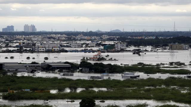
These meteorological anomalies have the potential to cause substantial harm in the southwestern and north eastern regions of India, particularly through the occurrence of cyclones, floods, or damage to the areas along the coast from 18th to 25th of May 2024..


Impact of Nautapa on Indian Monsoon Pattern in 2024 – Heatwaves and Rainfalls goes back to back
 

https://www.pmfias.com/south-west-monsoon-season-south-west-monsoons-arabian-sea-branch-bay-of-bengal-branch/

Image Courtesy : PMS -IAS


Now lets understand how exactly Nautapa effects our pre-monsoon pattern. Technically Speaking, Nautapa is a result of the solar and lunar motions that occur during these nine days during the lunar month of Jyestha over Rohini Nakshatra (which, according to the Georgian calendar, finishes in May and begins in June).

The commencement of Nautapa takes place in the Rohini Nakshatras region and continues for a period of nine days unless and until it fully grabs ample of heat, moisture and atmospheric pressure in it that helps to fastens the condensation process in the coastal regions of India .

To understand the pattern of the South West monsoon we need to first understand Garbo-Dharan process of the clouds that starts during these 9 days. This Nau-Tapa, is a meteorological event, which has a tremendous impact on a global scale, normally begins on May 25 and continues until June 2nd or 3rd of each year because of the solar and lunar motion over Rohini Nakshatra.

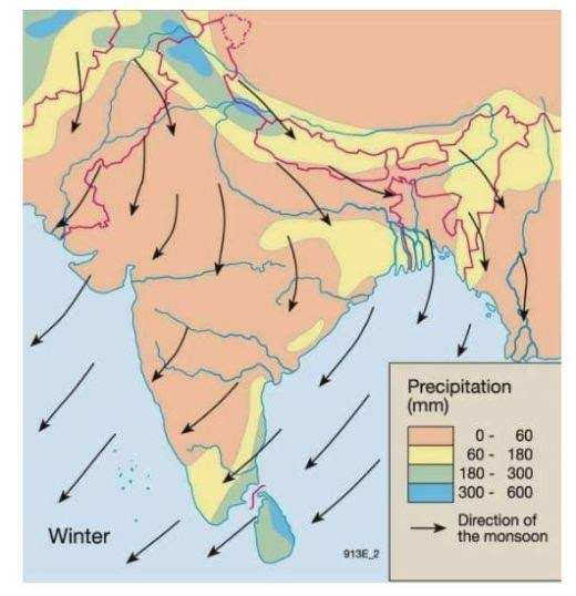
With regard to the conditions of the South Western monsoon, it has the most severe impact. It is still not known what caused the weather at Nautapa to be so significantly warmer than usual but scientifically speaking it indicates more about the Garbo-Dharan process of the clouds that helps to give clue of south west monsoon  winds pattern from South west coastal regions toward Central to, North Eastern and North Indian region.


Importance of Wind Movement during Garbhodharan, Nautapa and Pre-Monsoon 2024


Quality of winds Nautapa Vedicsiddhanta Exploring Astro-meteorological Analysis of Nautapa and Extreme heatwave patterns in India and the world for the monsoon condition of 2024

The quality of wind flow in Medini or Mundane Astrology is important for timing rainfall and the pattern of wind flows In Medini or Mundane astrology, movement of the wind flow, air quality, and atmospheric pressure play a bigger role in understanding the quality of rainfall during the monsoon and early months of the rainy months of February/March and the initial days of April, ruled by Phalgun and Chaitra.
Usually it has been seen whenever Saturn or Mars rules Gemini, Libra, and  Aquarius signs ( Airy Signs) in any year, i.e., in conjunction, in opposition, or square( 0-30, 180 or 240 degrees) to each other, it controls strong wind flow from the south-west wind movement that we usually check during monsoon time during the Ardra Parvesh chakra when the sun enters in Ardara Nakashtra.
We have to monitor the wind movement from the coastal regions of the north-west of India toward southern India during Ardara Parvesh. The greater the number of planets in the Airy signs and Vayu Nadi, the better we can understand the wind movement during the rainy season.
Usually, both Jupiter and Saturn govern the quality of wind flow, with stronger rules in the south-west and north-west monsoon wind movements. Jupiter governs the south-west wind pattern, while Saturn governs the north-west monsoon winds.
In year 2024,  Saturn is in the Airy sign, i.e., Aquarius, and there is no other airy planet that sits in any airy sign or in Vayu Nadi, either in trine or square to it, which means it has strong role in the wind movement in the north-west during the stay of Saturn in the Aquarius sign, which we have to monitor during Jyestha (May-June) month for the quality of rainfall in the monsoon which is actually the month of Nautapa 2024 and Ardra parvesh chakra of the Surya for the monsoon pattern of year 2024.
According to the koorma chakra, during this monsoon season of 2024 , the northern regions such as Jammu and Kashmir, Himachal Pradesh, Punjab, and Uttarakhand will receive substantial rainfall, while the southern region will encounter dry, warm weather due to the dominance of north-west wind movements until May 9th 2024 and later on pattern of the heatwave will shift toward North India zone ( Haryana, Himachal Pradesh , Punjab, Rajasthan,  Chandigarh, Delhi, Jammu and Kashmir, Ladakh , Uttar Pradesh  & Uttarakhand ),  Central India zone  ( Central India consists of two Indian states: Madhya Pradesh and Chhattisgarh and the areas lying in the borders of  Rajasthan, Gujarat, Odisha, Jharkhand, Uttar Pradesh, Maharashtra and Telangana. ) and North West zone ( The term “Northwest India” refers to region often comprises Rajasthan, western region of UP, Gujarat , Pakistan. The elevated region in Northwest India is characterised by the Western Himalayas, while the lower region is comprised of the central section of the Indo-Gangetic plains and the Thar Desert ) falling as per the Koorma Chakra.
There will be possibility of this year these Zones of India will experience temperature around 47-48 degree and  may be more can be expected in north western India zone  and temperature can touch around 49 or 50 degree. Meanwhile, Jupiter will remain in Kritika Nakashtra, under the influence of Prachanda Nadi, signifying dry winds and aggressive wind movement, which will intensify with the rise in warm weather in the  northwest and central region of India this summer season.
Due to the absence or lack of influence of Jala tattva Grahas on Nakashtra and signs ruling the southern region, such as Virgo, Libra, Scorpio, and Leo signs, we are already witnessing strong warm weather and heatwave patterns in southern India. We can observe strong rainfall in the southern India region once there is movement of the Sun, Mercury, and Venus in Leo and Virgo signs in Nakashtra.

Decoding Vayu-Dharan Process ( Pregnancy of Clouds ) for Monsoon situation of 2024


Nautapa and Vayu Dharan Process Exploring Astro-meteorological Analysis of Nautapa and Extreme heatwave patterns in India and the world for the monsoon condition of 2024
As per the early Ancient observations, the four days commencing from the “eighth day in the light half ( Krishna Paksha) of the month of jyestha (i.e 4 days after the mid of the month of the may and June – from 15th may to 15th June, it can be varied) fall in may and June month are Known as, “Vayu Dharan Days (Pregnancy days of Clouds) “
These are the most important days when the movements of the wind are seen and observed in the jyestha month freely from ” North-west to East direction carrying full of rich amount of moisture in it”.
In the Science of Astro-meteorology, These 4 days when the wind is heavy, Pressure is quite low in the environment and carries lots of moisture in it. Around this period, the Moon movement would be seen from ” Swati to visakha nakashtra” before Poornima, giving vital clue for judging the nature of health of the Pregnancy of the rain-clouds for upcoming monsoon seasons. Here observation of the wind direction and its richness or quantity with Apah (moisture), and movement in these particular 4 days are most important. If there is no wind in these 4 days, we can expect the coming months will be much dry in nature as well as humidity will be more.
If there are enough winds in those 4 days, should be like gentle, agreeable and if the Sky Should be covered by fine, bright clouds than there will be the possibility of good rainfall in Monsoon else monsoon will be a bit delayed and level of humidity will be more. If there is rainfall during” Swati to Vishaka Nakshatra for full 4 days ” then we can say with surety that the monsoon is near to Shower full of insistent rainfall in Shravana to Karttika Month (August to November) else there will be the possibility of drought like situation in the rainy season.
In Ancient Weather science, This gives an easiest way to time entry of monsoon via your own sense of judgement and to get clear understanding of the clue for rainfall during Sharavana and Karttika month.
The only thing required is you need to keep on observing the movement in the sky, the direction, and pregnancy of winds and clouds.
Below are the points required for Mundane analysis of rainfall, please note it down and carefully follow those.



Vedicsiddhanta Clouds Exploring Astro-meteorological Analysis of Nautapa and Extreme heatwave patterns in India and the world for the monsoon condition of 2024
1) Wind Direction in Monsoon : See the direction of the wind first, it should be from North- east/ west to south, See the speed, See the depth, See the content of moisture in it, Show how warm or cold it is, See the level of storm factor in it.If it is stormy in nature Chances of pregnancy will be wash away by the fierce wind.If the wind is full of cold and smooth in movement, rainfall will fall soon.The direction of winds shows how it will cover the moisture in the atmosphere, usually if air is smooth moisture will always be in intact with the wind.
wind movement vedicsiddhanta Exploring Astro-meteorological Analysis of Nautapa and Extreme heatwave patterns in India and the world for the monsoon condition of 2024
2) Cloud Movement in Monsoon : See the #Cloud movement from Northwest to South in the sky, Observe its motion – Moving or it is still or stays for a much longer period or not, See the color of the clouds. See how close clouds are moving toward the surface. More they are closer to the surface, better chances are for cold weather and cool breeze.
During the day of rainfall, there will be slight warmness in the environment.
Cloud movement Vedicsiddhanta Exploring Astro-meteorological Analysis of Nautapa and Extreme heatwave patterns in India and the world for the monsoon condition of 2024
3) Atmospheric and Humidity in Monsoon :  Note down the #atmospheric pressure, if it is too much humidity in the atmosphere with Warm weather or if it is the hot windy environment, Rain will be delayed. If it is a cool breeze in air rain will follow soon. you can observe the content of water in Atmosphere. If it is high-pressure weather will be good but it will delay rainfall in the coming days. If it is Low pressure after some period of rainfall will be there soon when the moon will transit to Jala Nadis with nodes or Jala Grahas around Mercury or Venus in Jala signs ( Cancer, Scorpio, and Pisces)
Atmospheric Pressure Vedicsiddhanta Exploring Astro-meteorological Analysis of Nautapa and Extreme heatwave patterns in India and the world for the monsoon condition of 2024
3) Cloud Appearance in Monsoon : If there are #blackish or #bluish #clouds sky and are very close to the surface or place where they appear, rainfall will come soon within 5 to 7 days soon after Surya enters Ardara Nakashtra.
Currently, the Sun will be with Mercury so chances of rainfall will be more especially in Eastern and Northern India.
Cloud Colour apperance vedicsiddhanta Exploring Astro-meteorological Analysis of Nautapa and Extreme heatwave patterns in India and the world for the monsoon condition of 2024
4) Carefully Observe Sankranti Movement : Watch carefully the wind intensity, Speed, Motion, denseness, if it is stormy, dry and warm in nature rain will be delayed. Hot winds have the capacity to clear the low pressure in air. If during Sankranti some rainfall has come, or you observed water content in the air, or Cold factor in wind its an indication rainfall will be good in the upcoming monsoon season soon after Aradra Parvesh of the sun.
Birds animals rainfall vedicsiddhanta Exploring Astro-meteorological Analysis of Nautapa and Extreme heatwave patterns in India and the world for the monsoon condition of 2024
6) Birds, Animals and Aquatic Movements : Observe the #birds, #animals and #aquatic animals movement in the sky and land both, if u see lots of birds moving in the sky, especially those came around Swati nakshatra, then chances of rain will be high in your environment and rainfall will be good. Birds Sounding in the environment indicates that weather will be good. Their movement and nature show the intuition they got from nature.

Vayu-Dharan Process of 2024 – Predicting Rainfalls, South-west Monsoon Pattern in India 2024


Nautapa year 2024 vedicsiddhanta Exploring Astro-meteorological Analysis of Nautapa and Extreme heatwave patterns in India and the world for the monsoon condition of 2024


This year, the #Vayu Dharan process will start from ”June 6th, 2024, onward when the moon will enter Jyestha Nakashtra, and there will be the beginning of Jyestha month via Jyestha Amavasya. During that, the sun will be in Taurus Sign in Rohini Nakashtra, and those 8 light half days will start from “6th of June to 13th/14th of June 2024 (from Pratipada to Ashthami Tithi) “.

In those 8 days before the beginning of the Vayu Dharan process (pregnancy of clouds), Mars will be behind the Sun, and there will be a conjunction of 5 planets with the Sun, Moon, Mercury, Venus, and Sun in Taurus. Majorly in the stars of Rohini and Kritika Nakashtra, where Jupiter is with Mercury behind the Moon and the Sun and Venus are in exact 22 Degrees conjunctions, it clearly shows the level of humidity and warm weather around that period.
As Venus, Sun, and Moon are in close conjunction during this period, central India and the majority of North India will experience very warm weather with a lot of moisture in the atmosphere. Another thing is that Ketu and Saturn will be in trine and Kendra to both Moons during the beginning of the Vayu Dharan process, which shows blockages for the good Vayu Dharan process, and we can experience much humidity in the southern, eastern, and northern areas of India.
This shows that during this Vayu Dharan process, there will be intense heat, and warm weather will start from the 13th or 14th of June onward, when those 8 light days will end. After those 8 light half days, 4 major Vayu Dharan Days will start around before poornima around the 17th or 18th of June up to the 20th of June 2024, “when the moon will be transiting from “Swati to Visakha Nakshatra around poornima (full moon day) that will fall around the 22nd of June 2024,” carrying a huge amount of moisture from the north-west coastal regions to the rest of India.
The contact of Mars in opposition to the moon shows the level of humidity and amount of moisture in the air during this period. During this period, Jupiter will be in Taurus (in Rohini Nakashtra in Vayu Nadi it shows a good amount of windfall , heat waves after carrying from Kritika that will cause good rainfall) and meet the Moon in opposition before entering Anuradha Nakashtra in opposition.
Jupiter shows a healthy cloud movement before the monsoon period and it is good for rainfall in Central and Northern India, whereas both Saturn and Jupiter will be in kendra to the Moon in Vayu and Neera Nadi Rule.
Ruled by Both Venus and the Sun clearly shows a good amount of wind movement along with rainfall during this whole season, and there will be ample rainfall in the northern & eastern region with good amount of wind movement, but there will be dryness and warm weather during the monsoon season in the south-eastern zone of India during this time.
The Sun, Mercury, and Venus will be in Gemini in Mrigshira Nakashtra shows that this year’s monsoon for India will have mixed results, and we will have heat as well as rainfall variations in different places but dryness will also prevail in the atmosphere in both the north and south zones before beginning of monsoon season.
This year, south-west India, north-west states, including Maharashtra, Karnataka, Kerala, and coastal regions of north-west Indian states may receive a normal amount of rainfall in early May and June, but later in July and August there would be a good amount of rainfall, whereas northern, north-eastern, and eastern states would receive a good amount of rainfall in monsoon season beginning probably after 16th July 2024.
During those 4 days of the Vayu-Dharan Process, from June 17th to June 18th, temperatures could cross 40’s degrees in Centra India, which shows planetary alignment that featured around June 6th to 10th triggers toward a high temperature and maximum moisture process for the whole tenure. If anyone hasn’t yet started observing the sky or weather scenario from June 6th, 2024, to June 13th, 2024, for the Vayu Dharan process, start observing the weather when the sun will move in Mrigshara Nakashtra, which is the period when wind will start it’s movement from the south-western coastal areas of India that shows rainfall scenario for the coastal areas of India, i.e., Kerala, Konkan, Maharashtra, Gujarat, and for the rest of the southern region of India, when the sun will move in Ardara Nakashtra, it shows more about the north of India rainfall scenario that we will discuss in separate article on south West Monsoon.

This shift, which is marked by Nautapa, is extremely important because it bridges the gap between the dry and scorching summer season and the monsoon season, which is eagerly anticipated. The understanding of Nautapa and the ramifications it has can provide extremely helpful insights into the patterns of climate and the planning of agricultural production. This age-old idea maintains important importance even in contemporary times, particularly in the context of climate change and its impact on regional weather phenomena, as we delve deeper into the meteorological elements that influenced Nautapa. This becomes apparent as we continue to investigate the factors that contributed to Nautapa.

An annual meteorological phenomena that is known as Nautapa, which translates to ‘nine days of heat’ in Hindi, takes place in some regions of India during the pre-monsoon season. The formation of Nautapa, which in turn adds to the extreme heatwave that occurred during this time period, is closely linked to a number of meteorological circumstances and atmospheric events.

The development of high-pressure systems over the Indian subcontinent is one of the key elements that has contributed to this situation. As a result of these systems, which are characterised by falling air, clouds and precipitation are prevented from forming, which results in bright skies and unending sunshine.

This heat is made more worse by the fact that there is not enough moisture in the air. When Nautapa is over, the air is normally dry, and the humidity levels are rather low. Because of this dryness, evaporative processes are unable to cool down, which leads to significantly greater surface temperatures. Because of the low moisture content, both the land and the air are able to heat up at a faster rate, which in turn makes the heatwave conditions even more severe.

Position of the sun in relation to the Earth is another important factor that played a significant role in the formation of Nautapa. Particularly in the tropical regions of India, the sun is virtually directly overhead during the latter part of May and the beginning of June to a certain extent. The position of the sun at its zenith ensures that the electromagnetic radiation that is received by the surface of the Earth is at its highest possible strength.


Process of Garbo-Dharana and South West Monsoon pattern in India -2024


South west monsoon vedicsiddhanta nautapa 2 Exploring Astro-meteorological Analysis of Nautapa and Extreme heatwave patterns in India and the world for the monsoon condition of 2024


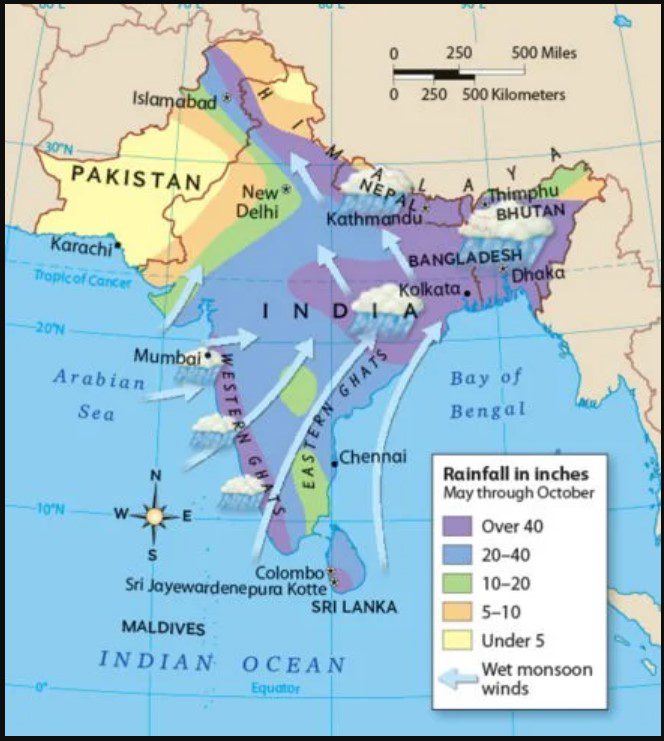
The monsoon winds that extend beyond south Kerala advance in the shape of two branches, namely the Arabian Sea branch and the Bay of Bengal branch. The Arabian Sea branch progressively extends in a northerly direction. The estimated arrival date in Mumbai is June 10th. The Bay of Bengal branch expands swiftly across the majority of Assam. The typical arrival date in Kolkata is June 7th.

The Himalayan barrier redirects the Bay branch in a westerly direction when it reaches the foothills of the Himalayas, resulting in its progression towards the Gangetic plain. The two branches converge, primarily near Delhi, to create a unified stream. Both branches arrive in Delhi about simultaneously. The collective electric current progressively spreads towards the western regions of Uttar Pradesh, Haryana, Punjab, Rajasthan, and ultimately reaches Himachal Pradesh and Kashmir. The monsoon is generally established in most regions of the country by the end of June.

By the middle of July, the monsoon season reaches Kashmir and the rest of the country. Upon reaching Kashmir, the precipitation had largely dissipated. The Arabian Sea branch of the monsoon is considerably more potent than the Bay of Bengal branch due to the following factors: The Arabian Sea surpasses the Bay of Bengal in terms of size, and The entirety of the Arabian Sea current moves into India, but just a portion of the Bay of Bengal current flows into India, with the rest continuing towards Myanmar, Thailand, and Malaysia.


Impact of Global Warming on Nautapa
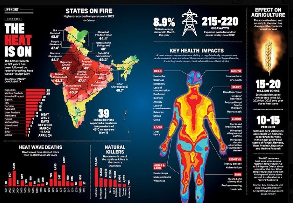
 

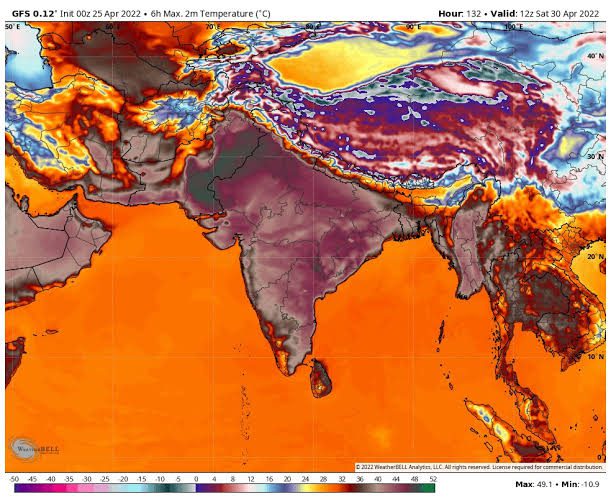
https://www.indiatoday.in/magazine/up-front/story/20220530-in-graphics-the-heat-wave-1951936-2022-05-20

Image Source : India Today | Tanmoy Chakraborty


Both global warming and climate change have a significant impact on the severity and characteristics of Nautapa, which is India’s traditional nine-day heatwave season which occurs every year. Temperatures that are quite high are characteristics of Nautapa. We believe that heatwaves such as the one that occurred in Nautapa will grow more powerful and linger for longer periods of time as the average temperature of the earth continues to rise from previous levels. There are a number of factors that can be ascribed to this occurrence, including greater baseline temperatures and shifting patterns of atmospheric circulation.

According to the findings of a recent study, the frequency and severity of heatwaves in India have dramatically increased as a direct result of global warming. Since pre-industrial times, the average temperature of the entire planet has risen by around 1.2 degrees Celsius, as indicated by studies. Predictions indicate that this trend will continue if there is not a significant reduction in emissions of greenhouse gases over the course of the next few decades. As a result of this increase in temperature, there will be an increase in the number of instances of extreme weather, including heatwaves that continue for an extended period of time.

Alterations to the patterns of the monsoon are one of the most significant factors that are contributing to the intensification of the effects of Nautapa. As a consequence of climate change, the behaviour of the monsoon has grown increasingly irregular and unpredictable. This is because climate change has altered the beginning of pre-monsoon conditions as well as the strength of those conditions. When the monsoon arrives later than expected, heatwaves might last for longer periods of time than they would otherwise. Furthermore, alterations in the patterns of precipitation can have an impact on the levels of humidity, which can make heatwaves even more uncomfortable.

In places with a high population density, the effects of heatwaves are made worse by urbanisation and a phenomena that is referred to as the urban heat island effect. Cities with extensive concrete and asphalt surfaces have a tendency to absorb and keep more heat, which results in higher temperatures. This is in contrast to rural environments, which tend to have a lower capacity for heat absorption and retention. This urban heat island effect, in conjunction with rising global temperatures, has the potential to bring about heatwaves that are more severe and continue for a longer amount of time throughout the Nautapa period.

It is likely that future Nautapa periods will see heat levels that have never been experienced before if the trends that are currently occurring continue. This would provide significant risks to the public’s health, as well as to agricultural and water supply systems. The forecasts made by climate models and predictive models indicate that the current trends will presumably continue. We have an immediate and pressing need to take comprehensive climate action in order to mitigate the effects of global warming and adapt to circumstances that are changing in the environment. If we are going to be successful in overcoming these challenges, we will need to make a concentrated effort on both the national and international levels. The implementation of climate policies that are effective, the adoption of sustainable behaviours, and the use of renewable energy sources should be the primary focus of this effort.

Astro- Meteorological Predictions for 2024

While we are getting closer to the pre-monsoon season of 2024, climatic forecasts show that Nautapa, the infamous nine-day period of high heat, will once again create substantial issues across the entirety of India. The current models and data indicate that the severity of the heatwave will be significantly severe, and it is anticipated that temperatures will rise to levels that are significantly higher than the averages for the season. It is estimated that this heatwave will last for a period of nine days, during which time temperatures are expected to reach levels that have never been seen before. This duration is consistent with the trends that have been observed in the past.

Detailed projections have been offered by experts from renowned meteorological institutes, such as the India Meteorological Department (IMD) and the National Centre for Medium Range Weather Forecasting (NCMRWF). These forecasts are based on advanced climate models. The projections that have been made shed light on the geographical impact that Nautapa will have, with the northern and central regions of India being the ones that are expected to experience the most severe temperatures. There is a high probability that cities such as Delhi, Jaipur, and Nagpur may see extreme heat conditions, capable of potentially surpassing records that have been observed in past years.

A senior meteorologist at the Indian Meteorological Department named Dr. Ramesh Kumar highlighted the fact that the combination of high-pressure systems and delayed monsoon onset is anticipated to make the severity of the heatwave even worse. “This year, we are observing stronger-than-usual high-pressure systems that trap heat and prevent cloud formation, leading to prolonged periods of intense heat,” according to the scientist. The urgent need for adaptive measures in response to rising global temperatures is brought to light by the fact that experts are warning that larger climatic changes could be the cause of the growing frequency and intensity of heatwaves.

Taking into consideration these forecasts, it is of the utmost importance for communities and local authorities to make preparations for the imminent heatwave. In order to mitigate the negative impacts of Nautapa, it will be particularly important to establish cooling centres, make certain that there is an appropriate supply of water, and educate the general population about the dangers of heat-related illnesses. These preparatory measures will be guided by the data-driven insights offered by meteorological institutions, which will play a crucial role in guiding these efforts and helping to protect public health and infrastructure during this period of extreme heat.

Impact on Agriculture and Water Resources

The 2024 Nautapa heatwave poses significant challenges to agriculture and water resources in India. Extreme heat during this period can severely affect crop yields, soil moisture, and water availability, thereby threatening food security and livelihoods in agrarian communities. The high temperatures accelerate the rate of evapotranspiration, leading to reduced soil moisture levels and increased water stress for crops.

One of the primary concerns is the impact on crop yields. Crops such as wheat, rice, and maize are particularly vulnerable to heat stress during their critical growth stages. Prolonged exposure to temperatures above the optimal range can lead to reduced grain filling, lower biomass accumulation, and ultimately, decreased yields. Moreover, the heatwave can exacerbate pest and disease outbreaks, further compromising crop health and productivity.

Soil moisture depletion is another critical issue. The extreme heat can cause rapid evaporation of water from the soil, leading to dry and arid conditions. This not only affects the current crop cycle but also has long-term implications for soil health and fertility. Farmers may face difficulties in maintaining adequate soil moisture levels, making it challenging to ensure the successful germination and growth of crops.

Water availability is also a significant concern during the Nautapa heatwave. The increased demand for irrigation water, coupled with the reduced availability of water resources, can lead to conflicts over water use. Rivers, reservoirs, and groundwater sources may experience significant depletion, impacting not only agriculture but also drinking water supplies for communities.

In response to these challenges, farmers and communities are adopting several strategies to mitigate the impacts of extreme heat. These include the use of drought-resistant crop varieties, efficient irrigation practices such as drip and sprinkler systems, and the implementation of soil moisture conservation techniques like mulching. Additionally, rainwater harvesting and the use of weather forecasting tools can help farmers make informed decisions about planting and irrigation schedules.

Overall, while the 2024 Nautapa heatwave presents considerable risks to agriculture and water resources, proactive measures and adaptive strategies can help mitigate its adverse effects, ensuring the resilience and sustainability of India’s agricultural sector.

Health Risks and Safety Measures

Extreme heatwaves, such as the Nautapa’s 9-day event, pose significant health risks to the population. One of the most severe conditions associated with heatwaves is heatstroke, a life-threatening situation where the body’s temperature regulation fails. Symptoms include confusion, seizures, and loss of consciousness, necessitating immediate medical attention. Additionally, dehydration is a common consequence of prolonged exposure to high temperatures, leading to symptoms like dizziness, dry mouth, and decreased urine output. It is crucial to maintain adequate hydration by drinking plenty of fluids, even if not thirsty.

Heatwaves can also exacerbate chronic illnesses, particularly cardiovascular and respiratory conditions. Individuals with pre-existing health issues should take extra precautions, such as staying indoors during peak heat hours and ensuring they have access to necessary medications and medical care. Vulnerable populations, including the elderly, children, and those with chronic health conditions, are especially at risk and require vigilant monitoring.

To mitigate these risks, several safety measures are recommended. First and foremost, staying hydrated is essential. Water should be consumed regularly, and beverages that can lead to further dehydration, such as alcohol and caffeinated drinks, should be avoided. Wearing lightweight, loose-fitting clothing helps in maintaining body temperature, while hats and sunglasses offer protection against direct sunlight. Staying indoors, especially during the hottest parts of the day, and using fans or air conditioning can significantly reduce heat exposure.

Communities can play a pivotal role in safeguarding their members. Establishing cooling centers and ensuring they are accessible to the most vulnerable can provide much-needed relief. Public awareness campaigns by health professionals and emergency services are crucial in disseminating information on recognizing the signs of heat-related illnesses and the importance of staying cool and hydrated. Simple measures like checking on neighbors, especially the elderly or those living alone, can make a significant difference in community resilience against extreme heatwaves.

Conclusion and Future Outlook

As we have explored, the Nautapa period brings about a significant and challenging weather phenomenon characterized by extreme heatwaves in India. Understanding the meteorological factors behind these nine days of intense heat is crucial for preparedness and resilience. Throughout this blog post, we delved into the atmospheric conditions, historical data, and implications of Nautapa, highlighting how these extreme temperatures impact both the environment and the population.

The increasing intensity of heatwaves, exacerbated by climate change, underscores the need for ongoing research and adaptation strategies. Meteorological studies and data analysis are essential in predicting and preparing for such events. It is imperative for scientists, policymakers, and the public to work collaboratively to develop effective strategies to mitigate the adverse effects of these extreme weather conditions. This includes advancing early warning systems, improving infrastructure to withstand extreme heat, and promoting public awareness about heatwave preparedness.

Technological advancements hold promise in addressing these challenges. Innovations in climate modeling and forecasting can lead to more accurate predictions, allowing for timely interventions. Similarly, urban planning and building designs that incorporate heat-resistant materials and green spaces can help reduce the urban heat island effect, providing some relief during intense heatwaves. Additionally, policy measures aimed at reducing greenhouse gas emissions and promoting sustainable practices can play a pivotal role in mitigating the long-term impacts of climate change.

In conclusion, while the threat of increasingly severe heatwaves due to climate change is a daunting challenge, it is one that can be met with concerted efforts and innovative solutions. By leveraging technology, enhancing research, and implementing robust policies, we can build a more resilient future capable of withstanding the rigors of extreme weather events like Nautapa. Through proactive measures and global cooperation, it is possible to mitigate the impacts and protect communities from the harsh realities of extreme heat.


With Thanks and Regards,

Rocky Jamwal

Source, Reference and Links 

[1]. Weather and Earthquake by B.V Raman

[2]. Brihat Samhita by Varahmihira, Commentry by Dr Ramakrishna bhatt

[3]. Internet for various Data, Images and research.

pin Exploring Astro-meteorological Analysis of Nautapa and Extreme heatwave patterns in India and the world for the monsoon condition of 2024

Views: 139

Astro-Metrology and blizzard winter of 2024 : The enigma of planetary alignment causing dense fog, blizzard cold and dry winter spell in India and globally

dense fog and winter 3 Astro-Metrology and blizzard winter of 2024 : The enigma of planetary alignment causing dense fog, blizzard cold and dry winter spell in India and globally

Introduction

In light of the fact that we are looking forward to the winter of 2024, it is essential that we have a solid understanding of the potential meteorological issues that may be encountered in various regions of the world. We will be concentrating on the winter forecast and weather issues in the United States of America, India, and Europe in this particular blog article. More specifically, we will be analyzing the impact of blizzard cold, snowfall, and dry winter spells that are caused by El Niño.

There is a possibility that certain places in the United States of America will suffer colder temperatures and an increase in snowfall in 2024, according to the winter prediction. It is anticipated that the northern states, including Minnesota, Wisconsin, and Michigan, will have temperatures that are lower than typical and a greater amount of snowfall. These places may experience difficulties in terms of transportation, infrastructure, and day-to-day life as a result of this.

On the other side, it is possible that the southern states, such as Texas, Florida, and California, may see temperatures that are milder in comparison to the winters that have occurred in the past. On the other hand, it is essential to keep in mind that winter weather can be rather unexpected, and that there is always the possibility of isolated variances.

During the winter season of 2024, the winter forecast for India shows that certain locations may have a winter period that is both drier and colder than usual. It’s possible that the northern states of Himachal Pradesh, Uttarakhand, and Jammu and Kashmir could have temperatures that are lower than average and more precipitation than usual. This may have an effect on agricultural activity as well as the amount of water that is available in certain regions.

On the other hand, southern states such as Kerala, Tamil Nadu, and Karnataka could see temperatures that are more moderate and amounts of precipitation that are more typical. The fact that India’s climate is varied is something that should be taken into consideration, as it is possible for different locations to experience different winter weather patterns.

It is possible that Europe may see a variety of weather conditions during the winter of 2024, according to the winter forecast for Europe. There is a possibility that northern countries such as Norway, Sweden, and Finland will experience lower temperatures and an increase in the amount of snowfall. This may have an impact on transportation systems as well as activities that take place outside.

In the meantime, western nations like the United Kingdom, France, and Spain can experience temperatures that are more moderate and typical levels of precipitation. It is essential to keep in mind, however, that weather patterns are subject to quick change, and that differences on a local level are certainly a possibility.

Impact of El Nino on weather forecast of 2024

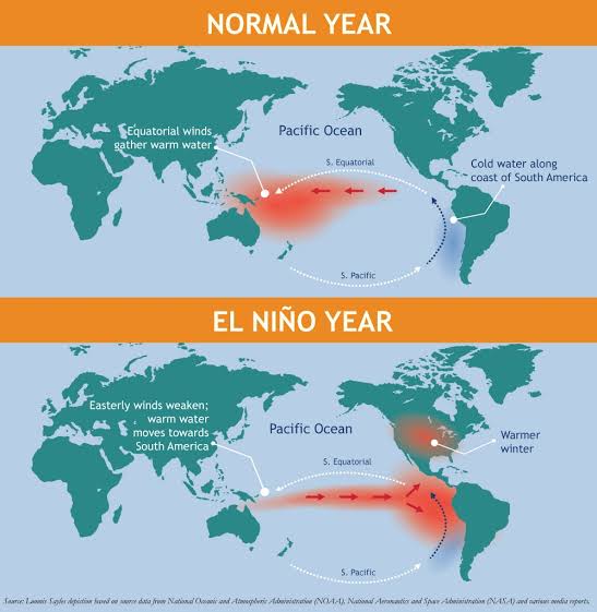
The climatic pattern known as El Niño, which is marked by sea surface temperatures that are higher than the usual in the Pacific Ocean, has the potential to exert a substantial influence on winter weather patterns all over the world. There is a possibility that certain places will endure blizzard cold, significant snowfall, or dry winter spells by the time an El Niño event occurs.

The term “blizzard cold” refers to conditions in which temperatures are extremely low and heavy winds are present. This combination may result in hazardous wind chills and frostbite risks. This can create difficulties for individuals in terms of their ability to participate in outside activities, transportation, and their overall well-being. In these kinds of conditions, it is essential to remember to take the necessary precautions in order to keep oneself warm and to protect oneself.

When there is a significant amount of snowfall, it can cause traffic disruptions, schools to close, and difficulties in clearing roads and sidewalks. In the event that severe snowstorms occur, it is of the utmost importance to adhere to safety recommendations and be ready for the possibility of power outages as well as restricted access to key services.
It is possible for dry winter spells to have severe repercussions for agriculture, water resources, and the overall health of ecosystems.

The decreased precipitation that occurs during these times can result in drought conditions, which can have an impact on agriculture output, water availability, and the habitats of some fauna. It is essential for communities to engage in water conservation activities and to encourage the use of environmentally responsible agriculture methods.

In spite of the fact that the effects of El Niño-induced extreme cold, snowfall, and dry winter spells might vary from one place to another, it is of utmost importance for individuals, communities, and governments to remain well-informed, well-prepared, and resilient when confronted with the possibility of winter weather issues.

In conclusion, the winter prognosis for 2024 indicates that conditions will be different in Europe, India, and the United States of America. It is of utmost importance for individuals, communities, and authorities to have a comprehensive understanding of the possible impact of El Niño-induced extreme cold, snowfall, and dry winter spells. This understanding is essential for properly preparing for and mitigating the issues that may develop throughout the winter season.

India and the world are affected by dry winters, dense fog, tough meteorological conditions, and the influence of El Niño.

Dense fog, The Fog Chronical_Vedicsiddhanta

Welcome to The dense Fog Chronicles and dry winter spell in India for the year 2024 ! In this blog post, we will explore the phenomenon of dry winter spells in India and around the world, specifically focusing on the year 2024. As climate change continues to impact our planet, it is crucial to understand the various weather patterns and their implications.

As the winter season sets in, many parts of the world experience a phenomenon known as dense fog. Acute snowfall, dry winter spell and some of the places are without Snowfall and rainfall. This natural occurrence can have a significant impact on various aspects of life, from transportation to public health. In recent years, the enigma of dense fog, Dry winter spell and weather anomalies has become even more complex due to the influence of increasing effect of the El Niño , global climate changes as per most of the climatic scientists and weather science learners are exploring a climate pattern that affects weather patterns worldwide.

In this article, we will explore the connection between dense fog, dry winter spells, and the global repercussions of El Niño’s wrath on India and the rest of the world. We will Learn about the winter forecast and potential weather challenges in the USA, India, and Europe for 2024 and we try to understand about about blizzard cold, snowfall, and dry winter spells for the year 2024 via astrometeorology and weather forecasting system of the indian jyotish system and try understand whether El Niño is the real cause for this year intense weather challenges which is impacting transportation, infrastructure, agriculture, and daily life. Stay informed and prepared to mitigate the challenges of winter weather.

Understanding Dry Winter Spells in Hilly regions of india for the year 2023-24

Fog chronical Vedicsiddhanta Astro-Metrology and blizzard winter of 2024 : The enigma of planetary alignment causing dense fog, blizzard cold and dry winter spell in India and globally

The winter season in northern India became more severe, resulting in the occurrence of dense fog over several states. The minimum temperatures in Punjab, Haryana, Rajasthan, and Uttar Pradesh ranged from 6 to 9 degrees Celsius, while New Delhi, south Rajasthan, and north Madhya Pradesh witnessed temperatures ranging from 10 to 12 degrees Celsius. A significant portion of Northern India encountered dense fog, resulting in visibility dropping to as little as 6 feet for many consecutive days. Foggy conditions were seen in Haryana, Chandigarh, as well as isolated regions in Uttarakhand, Uttar Pradesh, Bihar, Rajasthan, and Madhya Pradesh, resulting in visibility dropping to less than 200 meters.

As per Kashmir Vision, newspaper , In December 2023, the union territories of Jammu & Kashmir and Ladakh experienced extremely dry conditions, with a rainfall deficit of 79% and 100% respectively. Dr. Muhammad Muslim, an Assistant Professor in the Environmental Sciences department at Kashmir University, stated that there are evident signs of climate change. “Upon analyzing historical data, there are evident indications of climate change.” “Regarding the precipitation regime, it is clear that we are experiencing both a reduction in precipitation and a change in the pattern of precipitation,” he stated.

Fog_Chronical_Dense_Fog

IMD Satellite image : Clearly shows North india to north west india is covered by the dense fog.

As per IMD satellite image we can clearly see that whole Northern india to north west india is covered with the dense layer of fog impacting from J&K, to Punjab, West Up, Bihar, west pakistan, Rajasthan, central india etc.

“There is a noticeable change in winter precipitation.” Dr. Muslim stated that there is a decrease in precipitation in both India and Kashmir, although the decline is not particularly noteworthy in the latter. He further explained that there will still be some precipitation, but it will mostly occur during the spring season.”The changing climate is a direct result of system behavior,” he stated, acknowledging the lack of comprehensive research to determine the primary factors behind this change. “Limited progress has been made in analyzing the drivers to determine the most significant factors,” he stated.

According to Dr. Sami-ullah Bhat, a senior assistant professor in the Environmental Sciences department at Kashmir University, the precipitation pattern is influenced by the wind directions, cloud movement, and the timing and impact of its interaction with the mountains.

Scientifically, Dry winter spells refer to periods of reduced precipitation during the winter season. These spells are characterized by a lack of rainfall or snowfall, resulting in drier and colder conditions. While winter is typically associated with cold weather and precipitation, these dry spells disrupt the normal climate patterns.

In recent years, many regions, including India, have experienced an increase in the frequency and intensity of dry winter spells. These phenomena can have significant consequences for various sectors, including agriculture, water resources, and even public health.

During the winter season, many regions of india are experience a dry spell characterized by a lack of rainfall in the month of October, November and December . This dry winter spell can exacerbate the formation of dense fog. The absence of precipitation reduces the moisture content in the air, creating ideal conditions for fog formation. As a result, the fog becomes denser and persists for longer periods.

India, in particular, is known for its dense fog during the winter months. The northern parts of the country, including the Indo-Gangetic plains, often witness prolonged periods of foggy weather. This has a significant impact on transportation and disrupts daily life for millions of people.

As per Kashmir observer, Many of weather scientists are claiming these dense fog and dry winter spell is occurring due to “El Niño, a cyclic series of climatic variations affecting certain areas of the Pacific region. As per the statement from the Director of the Meteorological Department, this is the lengthiest duration without noteworthy snowfall since 2015. According to him, the valley encountered its initial significant snowfall on January 24th, 2015. Usually, occurrences of El Niño and La Niña often happen at intervals ranging from two to seven years, although they do not adhere to a fixed pattern.

El Niño is a naturally recurring phenomena characterized by periodic increases in sea surface temperatures in the central and eastern parts of the Pacific Ocean. La Niña is characterized by below-average sea temperatures, representing the reverse of the normal conditions. Both El Niño and La Niña have a substantial impact on the weather patterns of Earth. El Niño has a higher frequency of occurrence compared to La Niña, as stated by the National Oceanic and Atmospheric Administration (NOAA).

The India Meteorological Department (IMD) forecasted higher than average minimum and maximum temperatures for the December-February period, influenced by the persistent impacts of El Niño and other regional factors. As a result, the majority of India is anticipated to see a milder winter this year. El Niño is officially defined when there is a sustained increase of at least 0.5 degrees Celsius in sea surface temperatures in the tropical eastern Pacific, compared to the long-term average.

As per Scientist, The elevated maximum and lowest temperatures experienced across the entire country during the period of December 2023 to February 2024 can mostly be ascribed to the occurrence of El Niño, which is known to cause higher temperatures. Furthermore, regional elements such as frequent western disturbances will result in cloud cover and lower minimum temperatures,” as stated by Mrutyunjay Mohapatra, Director General of the Indian Meteorological Department, at a virtual press conference.

Professor Shakeel Ahmad Romshoo, a specialist in Earth science and glaciology, supports the IMD forecast and predicts that the Kashmir valley will likely have a relatively mild winter with less snowfall than typical this year.Due to the ongoing El Niño phenomenon, hilly regions of india likely to see less severe winters with below-average snowfall. During an El Niño year, the Kashmir Himalayas typically get reduced snowfall. “It is responsible for the prolonged drought that has been witnessed in the valley recently.

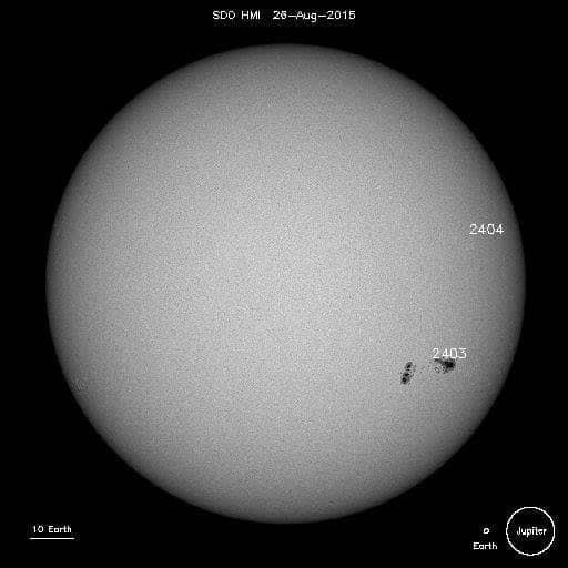
Astrologically Speaking ( as per rules of Medini Jyotish ) , Condition of Elnio and la nino occurrence is responsible due to the magnetic changes occurring in the Sun and the correspondent Sunspots visible in the solar region, Majorly responsible for the weather conditions in india and across the globe. In Year 2023, we have seen multiple times the visibility of the sunspots from May 2023 to July 2023 and also during the month of October 2023 as well. This has been widely explained in the Brihat Samhita in Chapter 3rd of Adityachar.

As per “ Acharya Varahmihira ” 33 Ketus or 33 Dark shafts has been observed in Sub orbits during particular sun transits in different-different signs with slow moving planets, Uniquely Named as “ TamasaKilakas “ and effects has been seen and observed based on Color, Positions and Shapes. Acharya further explains impact of “Tamasakilakas “ in various regions in earth Whenever these dark shafts has been appeared in sun facing earth regions during Sun transits: “ Water turns turbid, Sky is filled with Dust, Storm arises carrying sand and breaking the tops of mountains and trees, there appears Flares in the quarter; thunderbolts, earthquakes and other such unusual phenomena take place in earth, Clouds bearing rains activity observes and river usually becomes slender

( Quote 9, 10 and 13, Brihat Samhita of Varahmihiraby Ramakrishna Bhatt).

Ancient Weather and Mundane science Acharya, Varahmihira scientific explanations and Impact of Sunspots in “ Adityachar” in Brihat Samhita shows Hindu’s brilliant astronomers like “ Aryabhatta“and “ Varahmihira “ around 400 to 500 were already aware of Sunspots and potent impact of heliocentric Sun and their major Solar cycle activities in earth atmospheres.

This even shows without having modern instruments likes Telescope’s and Fixed large observatories Hindu ancient scholars were much eminent and expertized in observing and calculating Solar activities during Sun orbits.(Reference: BrihatSamhita of Varahmihira, “ AdityaChar “, Chapter 3 , Quote 7 by Ramkrishna Bhatt ).

Astrologically learners can observe major Sunspots activities in yearly transits when sun is closely com-busted or conjugated with slow moving planets like Jupiter and Saturn, Dr B.V Raman has explained many of remarkable conclusions on Sunspots during their research on Earthquakes and weathers changes.

It has been seen and observed by Dr B.V Raman, whenever Sun transits in any signs having Close relation with Major Slow moving planets like Saturn and Jupiter – major Sunspots activities usually noted by astronomers across the globe. Sometime Small sunspots activities also been noted when Sun is superiority conjugated with Venus and Mars and usually appears in Solar discs areas and further massive solar flares activities also been observed by astronomers too.

Impact of these sunspots activities in earth atmospheres has been observed in Feb 2015 and might be even later impact was seen. Later activities Seen in weathers during Full Solar eclipse occurred in March 2015, lunar eclipse occurred on April 2015 and finally after Sun ingress in Aries in 0 degree in April 2015 month changed the whole scenario of weather situation in earth in eastern regions.

Important Astrological factors resposible for climatic conditions changes

1) Role of Sun and Mars: If both Sun and Mars are closely conjugated or having close relations in same house in Ardara Parvesh chakra, usually gives intense dry and warm weather for that year and there will be intense heat waves before start of monsoon. If Sun is behind Mars, there will be possibility of no rains for whole monsoon season.

2) Sun and Saturn: Whenever both sun and Saturn are closely placed in one rashi, usually in summer, intense heat waves observes and in winter usually observes acute cold with good amount of Snowfall.

3) As per mundane rules Saturn is considered as karaka for dry and cold winds and usually it gives dryness and acute coldness in atmosphere’s depends on seasonal changes and whenever it is placed in Jala Nadi it usually gives Strong windstorm of water and air and storms can cause massive cyclones in coastal regions and wrecking of ships via thunderstorms is a role of mars when it is with Saturn or getting aspect from mars in coastal areas.

If Saturn is in airy nadi, it usually drives away all the clouds responsible for rain with its huge blow of wind and dryness.

If Saturn is in Agni nadi, it usually gives intense dry heats waves; Dusty wind storms and heavy storms which are very powerful and even can break any buildings or obstacle come over their paths.

Sapta nadi Chakra is again a very useful tool or an ancient chakra schemes used by our sages in predicting weather, floods, thunderstorms, cold conditions, and heat waves patterns especially for rainfall and it is a best tool to use for predicting Monsoon activities in India around sun movement in ardara Nakashtra.

Though it can be used for world Rain patterns but it needs extensive work on with Koorma Chakra for World charts for locating Nakashtras. Mostly Explanation of Sapta Nadi Chakara is widely seen in two ancient sources of Saptanadi Chakra – Narapati Jayachara and Sage Parashara and all later texts are based on them. Original source of Sapta nadi Chakra was a tantric text titled ‘yamaleeya-Svarodaya’.

As Explained by Narapati Jayachara , it is used for Calculation on quantity of rainfalls starting from Kritika Nakashtra.

“ Pushya , Poorva Phalguni, Abhijeeta, Satabhishaq “ are fall in Jala nadi ruled by Mercury.

Prachanda Nadi usually gives huge blow of wind, Vayu Nadi gives normal volume of winds and Agni Nadi gives Immense Heat and warm weather.

Neera Nadi usually gives clue of entry of clouds and in Jala and Parachanda Planets give heavy rainfall.

If there is placement of Malefic, Moon and Beneficial planet in same sign or same nakashtra it usually gives huge amount of rainfall.

If there is Moon and any planet conjugated in same nakashtra at same day it gives heavy rainfall for continues 2.5 days till moon is conjugated with that planet.

If in Amrita Nadi both Malefic and Benefic planets are placed with moon it usually gives continues rain up to 3,4 or maximum up to 7 days.

In Jala Nadi If Moon is with Both Malefic and Benefic it can also give rain up to 1.5 or 5 days.

If in any nadi there is Moon, mars and Jupiter are closely placed it can also drown whole earth for some days. During planet direct motion, retrograde motion, and combustion and during any planet movement in sankranti in Jala nadi it usually gives excessive rainfall for few days.

Placement of Mars ahead than sun has capability to suck all clouds which are meant for heavy rain, it usually gives warm weather with no rain.

Mars with Sun usually gives excessive heat waves and warm weather and much possibility of high humidity.

For making a Sapta nadi Chakara we need to use 28 Nakshatra scheme. 28th Nakshatra ‘Abhijit’ is also allotted a space towards the end of Uttarashada.

These Nakshatras are subdivided into 7 Nadis starting from ‘Krittika’ (3rd Nakshatra) as ‘Vaat Nadi or Airy Nadi ’ followed by ‘Ati-vaat or PrachandNadi’, ‘Dahan’, ‘Soumya’, ‘Neera’, ‘Jala’ and ‘Amrita’.

Usually Vaat produces windy weather, Ati-vaat produces cold weather after Rainstorms, Dahan increases temperature depending on the environment as Dahan Nadi is very sensitive nadi wrt to nature and surroundings and it gradually increases with the time and environment, and Soumya, Neera, Jala and Amrita nadis are rain producing Nadis.

If there is in any case an unnatural activity has been observes in Saptanadi chakra, we can same also confirm via “Casting Hindu Near year chart for India “ based on entry of sun on “ Chaitra Shukala partipat tithi “.

By casting Hindu New Year chart we can cross check for any unnatural activity is damaging to country or not and what could be future situation for rain and crops in that particular year.The Sapta nadi chakara sequence follows a serpentine pattern as we have assigns Nakashtras based on Serpents in below mentioned Diagram, as suggested by shiri Narpati Jaicharya ji:

From January 2023, we have been witnessing unusual weather patterns due to the entry of Saturn into the Satabisha Nakashtra. The Satabisha Nakshatra is associated with windy conditions, intense rainfall, and cold weather during winter and rainy season, which can induces the condition of Ati-Vaat in atmosphere.

We have observed extreme rainfall since April 2023, when Jupiter joined with Rahu and Saturn influenced the Aries sign, which governs the northeastern region of India. Saturn in Aquarius indicates the northern region of India, while Scorpio represents the western region. Throughout the year, these regions have experienced severe weather conditions, initially with heavy rainfall and now with intense weather.

The dry winter period, once again linked to the Satabishaa nakshtra, is expected to occur in December 2023 without any alignment with Saturn.

Related Article :

Astro Meteorology Research study on Monsoon 2015 – Ardra Parvesh Chakra and South-West monsoon Pattern in India for 2015

The Impact on India

coconut palms in deep morning fog chronical vedicsiddhanta scaled Astro-Metrology and blizzard winter of 2024 : The enigma of planetary alignment causing dense fog, blizzard cold and dry winter spell in India and globally

India, with its diverse climate patterns, is no stranger to dry winter spells. In 2024, the country experienced an extended period of reduced rainfall and snowfall in several regions. This had far-reaching effects on agriculture, particularly in areas that heavily rely on winter crops.

During dry winter spells, the lack of moisture in the soil can hinder crop growth and reduce yields. Farmers may struggle to irrigate their fields adequately, leading to lower agricultural productivity. This, in turn, can have a ripple effect on the economy and food security.

Furthermore, dry winter spells can also impact water resources in the country. With reduced precipitation, rivers, lakes, and reservoirs may experience lower water levels. This can pose challenges for both domestic water supply and irrigation purposes.

Additionally, the lack of rainfall during the winter season can contribute to increased air pollution. Without precipitation to cleanse the air, pollutants and particulate matter can accumulate, leading to poor air quality. This can have detrimental effects on public health, particularly for individuals with respiratory conditions.

The Global Perspective of climate change

El Nino Astro-Metrology and blizzard winter of 2024 : The enigma of planetary alignment causing dense fog, blizzard cold and dry winter spell in India and globally

Dry winter spells are not limited to India; they are a global concern. In 2024, several countries across the world experienced similar weather patterns. Regions in Europe, North America, and Asia also reported reduced precipitation during the winter season. The implications of these dry spells vary depending on the geographical location. In areas where winter tourism is a significant economic driver, such as ski resorts, the lack of snowfall can have severe economic consequences. It can impact tourism revenue, employment opportunities, and the overall local economy.

Moreover, the ecological balance of certain regions can be disrupted by prolonged dry winter spells. Ecosystems that rely on winter precipitation, such as forests and wetlands, may suffer from water scarcity. This can affect wildlife habitats and biodiversity.

Adapting to Changing Weather Patterns

As we face the challenges posed by dry winter spells, it becomes crucial to adapt and mitigate their impacts. Governments, communities, and individuals can take various steps to address these changing weather patterns.

Investing in water conservation and management strategies is essential to ensure sustainable water resources. This includes promoting efficient irrigation techniques, rainwater harvesting, and the development of water storage infrastructure.

Furthermore, diversifying agricultural practices can help reduce the dependence on specific crops that are vulnerable to dry spells. Farmers can explore alternative crops or adopt techniques such as crop rotation to mitigate the risks associated with reduced winter precipitation.

On a broader scale, addressing climate change and reducing greenhouse gas emissions is crucial to prevent further disruptions to our climate patterns. This requires collective efforts from governments, businesses, and individuals to transition towards renewable energy sources and adopt sustainable practices.

Global Repercussions of El Niño’s Wrath, dense fog and dry winter spell

El Niño is a climate pattern characterized by the warming of the Pacific Ocean near the equator. It occurs irregularly, typically every 2-7 years, and has far-reaching effects on weather patterns worldwide. El Niño can disrupt the normal atmospheric circulation, leading to extreme weather events in various regions.

One of the consequences of El Niño is the alteration of winter weather patterns. It can lead to drier conditions in some areas, including India, resulting in an increased likelihood of dry winter spells. This, in turn, contributes to the formation of dense fog.

Furthermore, El Niño’s impact on global temperatures can exacerbate the intensity of dense fog. Warmer temperatures can increase the moisture content in the air, creating more favorable conditions for fog formation. As El Niño events become more frequent and intense, the enigma of dense fog is likely to persist and even worsen in the future.

The Enigma of Dense Fog in india from December 2023 to January 2024

Fog chronical kashmir vedicsiddhanta Astro-Metrology and blizzard winter of 2024 : The enigma of planetary alignment causing dense fog, blizzard cold and dry winter spell in India and globally

Dense fog is a meteorological phenomenon defined by the existence of condensed, low-altitude clouds that diminish visibility to less than 1 kilometer. It happens when there is a significant amount of moisture in the atmosphere along with low temperatures. This combination results in the condensation of moisture into minuscule water droplets, so generating a misty ambiance.

As per Kashmir vision, Weather analyst Faizan Arif Keng, who works independently, also commented on this matter, stating that a relatively mild Western disturbance during the Christmas period may not have resulted in much rainfall. However, it probably did contain a higher amount of moisture in the form of water vapor compared to ordinary conditions. The surplus moisture may have condensed into minuscule water droplets at the surface, resulting in the formation of fog.

Typically, he stated that wind aids in the dispersion of fog by blending and displacing the elevated warm air with the lower chilly and damp air. “Nevertheless, as a result of the lack of powerful winds originating from Western Disturbance, the foggy layer remained confined near the surface, resulting in an extended period of foggy conditions,” he stated. Following the cessation of the disturbance, the absence of clouds facilitated efficient radiational cooling. According to him, the fog became more intense, particularly in the mornings, due to the additional condensation of water vapor caused by rapid nighttime cooling.

On nights with clear skies, the earth’s surface emits heat, resulting in a quick decrease in temperatures. According to him, the quick decrease in temperature close to the surface causes the water vapor in the air to turn into fog.

The presence of dense fog can exert a substantial influence on multiple industries, with transportation being notably affected. Fog frequently leads to reduced visibility, resulting in aircraft delays and cancellations at airports. Incidents of road accidents tend to rise during foggy circumstances due to the challenges faced by drivers in maneuvering through the limited vision. In addition, the presence of dense fog can have detrimental impacts on public health, resulting in respiratory issues and allergic reactions.

Astro-Metrological understanding on weather challenges, Dense fog, dry winter spell and low snowfall for the year 2023-24

This year northern states may have long lasting winter due to Planetary alignments are moving more closer around February and March 2024 month and it will also impact selective states i.e Jammu & kashmir, uttrakhand, Himachal Pradesh, ladakh , Western Up, Western Punjab, North Western Pakistan, Afghanistan, Delhi NCR regions, few portions of Punjab region etc will have mixed winter, sometime acute cold and sometimes warm weather and we can expect a strong blizzard cold waves can start that can start from 17th to 28th December 2023 onward, though it will be for short term period but it will have good impact on weather and atmosphere.
Later on Mars & Sun conjunction will prevail bit warm weather in Northern and North Western areas but it also bad for the perception and effect badly the winter rainfall and the snowfall in the hilly that will have strong impact on winter condition of the December 2023 and eventually the dense fog and cloudy weather affettis will continue upto 12 January 2024, meanwhile Western area of india will have high chances to expect unexpected & sudden rainfalls from 29th December to 11th January 2024 onward.
Once, Jupiter becomes direct with Uranus in Aries, Neptune will mature its degree from 0 to 1 in Pisces with the loose conjunction of Rahu , we can see sudden disturbance in the economical world, chances of Financial crime, scam, along with certain military actions or kind of Anarchy on the eastern and North Eastern border areas of India or North eastern countries or there could be chances of some kind of geopolitical conflicts in the south eastern region due to some break in the treaty or signing authority.
The overall period from 8th January to 27th January is quite an active period for the Geopolitical issues around the globe which can have direct or indirect impact on the global financial world along with military activities that could be possible in the border areas also.
Currently, the sun is with Mercury, which is responsible for the wind condition require for the rainfall that india receive from west in the form of western disturbance helps to clear the weather and increase the chances cold wave with snowfall, as Sun is in deep conjunction with mercury it shows that cold waves will increase as soon as the sun moves closer to the Mercury in higher ranges of the India which can impact with sudden increase of cold waves in higher altitudes and cold waves will move toward the lower altitudes in the northern region from ending of December 2023 to mid of January 2024 though it will be for short term period but it will have strong impact on sudden change of weather from 18th December onward and during these dates temperature may fall rapidly from 15 degree to around 5 to 7 degrees in the night and stagnant weather condition in the day without the sun.
This also indicates the beginning of new sunspot regions in active areas of the sun , which can indicate sudden weather changes and chances of normal to average magnitude of earthquake from 17th to 28th of December in Ushan areas ( means areas where heat and lands are combined i.e desert areas ).
Though the sun and Mercury are without any affliction, it won’t impact the weather negatively but it will increase cold wave intensity suddenly from Western region.
Saturn will have a direct aspect on direct Jupiter and retrograde Uranus in Aries around the end of December 2023, which will further act as catalysts for weather anomalies along with sudden upheavals in the financial world.
As Jupiter and Uranus take time to achieve it mature state from stationary direct to natural direct, the months of January and December would be very interesting and would bring sudden geopolitical issues to the globe, which can impact the financial world, economy, and weather challenges in the whole globe.
Meanwhile, retrograde mercury will move back to the Scorpio sign, along with Venus, which also helps to intensify rainfall in the south-western and south-eastern regions of India, and further, Mars will join hands with the sun to increase warm winters in a few western regions of India.
The effect of winter will be there unless and until the sun is conjoined with Saturn, but later on, when the sun moves closer towards the north node of Rahu, we can expect sudden rainfalls in the northern and eastern regions of India in late February and March 2024.
Overall winter starts giving it its actual results in February and March month when there are good conjunction of planets with winter giving planetary alignment meanwhile after 16th January 2024 onward upto 1st February 2024 we can expect increase of sudden hot and cold weather simultaneously both northern region due to sun movement and conjunction of Mars with Venus & Mercury which can dry up the weather and usually clears the cloudy weather and helps to keep warm the atmosphere and air pressure also maintained due to change in the wind flow.

Entry of Blizzard cold waves and the impact on India : Understanding Sishir Ritu, Beginning of Dense Fog &
40 days of intense Winter condition

fog photos of indian village dnyaneshwar vaidya 01 Astro-Metrology and blizzard winter of 2024 : The enigma of planetary alignment causing dense fog, blizzard cold and dry winter spell in India and globally

In the current year, from December to January 2024, we are observing a dry and delayed winter season.
This delay is causing a postponement in the occurrence of cold waves and snowfall in the hilly areas of the Northern Hemisphere. The reason for this delay is the absence of any significant interactions between the planets #Venus, Moon, and Mercury, which are known to influence winter conditions, with the outer planets Uranus, Neptune, #Jupiter, and #Saturn.
The sole cause for the current dry winter conditions, characterized by a rising occurrence of frigid and dreary weather, together with cold waves and elevated fog levels across the plains of North India, is this. It is primarily responsible for the significant increase in dew, fog, and smog levels across the plains of the Northern Hemisphere.
Furthermore, Saturn is positioned in the satabisha nakshtra within the Aquarius sign, which is characterized by aridity and is associated with dry wind and precipitation. Currently, we are seeing arid cold fronts, a postponement of snowfall in mountainous areas of India, and insufficient winter precipitation in low-lying regions.
Astrologically, there is no astrological alignment or relationship between Saturn and Jupiter and the Sun, Venus, and Mercury. However, this lack of connection can contribute to a calm winter season and facilitate a significant amount of snowfall and winter rains with delay, As a result, we shall witness the authentic winter season throughout the latter part of February and March in 2024. From January 2nd, 2024, to January 7th, 2024, the alignment of planets will cause a significant decrease in temperature in the Northern Plains.
During this time, there will be a high level of moisture in the atmosphere, resulting in dense fog and a substantial amount of dew. Starting from January 8th, there will be a shift in wind direction accompanied by a significant increase in a cold wave. This phenomenon can also induce thunderstorms and light precipitation in the western area of the Northern Plains. Additionally, we can anticipate the impact of westerly winds from the western region extending to the northwestern parts of India.
Consequently, there will be a simultaneous increase and decrease in temperature. The duration of this will extend until January 15th, 2024.
Subsequently, as the sun transitions into the astrological sign of Capricorn, the meteorological conditions will ameliorate, resulting in a delightful day characterized by an uninterrupted presence of sunshine. During the period of January 18th to February 2nd, 2024, when Venus, Mercury, and Mars align with the Sagittarius sign, there will be a mix of sunny and rainy weather, as well as the possibility of thunderstorms.
These conditions may result in gloomy weather, heavy fog, and potentially chilly winter temperatures. One positive aspect is that when Venus approaches Mercury and Mars, it might result in atmospheric electrical discharges and occasionally intense precipitation with sizable water droplets, which may be accompanied by intense thunderstorms and gusty winds in the western ghats or maritime regions.
Starting from February 12th, we may expect a combination of rains and clear weather, making for a pleasant winter season. This year, the enjoyment of the winter season may be prolonged due to unfavorable planetary alignments occurring in February and March. Fortunately, we will be able to enjoy winter weather until March 2024, implying that winter precipitation may persist until April 2024.
Overall, We need to Observe the blizzard cold waves for up to the next 15 days from 28th of December upto 17th of January 2024 , where coming 3 days we can experience sudden or dramatic weather shift from 2nd January to 6th January 2024 onward and it will stretch upto 18th January in total and we can experience severe cold to coldest waves and blizzard in northern hemisphere of India , US , China etc, where US, Europeans regions will experience good amount of Snowfall but india will receive severe dry winter spell with dense fog where temperature drop can be in vital state in J&K, Punjab, West UP, Harayana, Himachal, North eastern regions of India , West Pakistan , New delhi , Few states of Western India , North eastern region of Ladakh etc.
These states of India will be in a vulnerable condition from December to the whole month of January 2024. Take pleasure in the cyclical variations of the seasons.

Understanding, The Shishir Ritu, Paush Month and the chilling winter season traditionally

the time sunil sheoran ritu Astro-Metrology and blizzard winter of 2024 : The enigma of planetary alignment causing dense fog, blizzard cold and dry winter spell in India and globally
With the beginning of Margashirsha Poornima , there is the beginning of Sishir Ritu ( intense Winter ) & Paush Month. The month of Margashirsha is closely linked to Lord Krishna and Paush month is dedicated to the lordship of Surya Dev and Lord Vishnu and closely linked with many seasonal changes. Autumn ( Sishir ) is a season that is part of the six seasons in India. According to the Vikram Samvat calendar, the months of Magha and Phalguna correspond to the season of ‘Shishir’, which is autumn. Makar Sankranti is also regarded as the starting point.
During the winter season, the temperature drops significantly, resulting in extremely low temperatures. A dense fog starts to develop. The directions intensify progressively, as though Vasundhara and Ambar have merged into a unified entity. Dew causes particles to get moist.
During this season, nature is flourishing. Foliage commences its descent. The entire area is enveloped in fog. Therefore, these seasons represent distinct stages of existence that imbue life with fascination, tranquilly, and fulfilment. The plant undergoes blooming during the winter season. An abundance of blooming plants available for purchase may be observed at the market.
Vegetable plants and creepers achieve their maximum productivity exclusively during this season. There is an abundance of vegetables on the market. The cuisine appears to be delectable, yet the flavour of the rasa is not reminiscent of its natural essence.The process of digestion accelerates to such an extent that regardless of the type or quantity of food consumed, complete digestion occurs.
The current period is referred to as Visharga Kaal, which signifies the conclusion of Dakshinayana.
During this period, the moon’s energy surpasses that of the sun. Consequently, throughout this season, there is a significant augmentation in the nutritional content of medications, vegetation, soil, and fauna. During this season, there is a buildup of kapha in the body, whereas pitta dosha is diminished.
During the winter season, the digestive capacity is heightened due to the naturally intensified stomach fire. This phenomenon occurs as a result of the impact of cold air, wind, and a frigid environment on the body’s skin, which hinders the release of internal heat. Consequently, the heat accumulates within the body and intensifies the stomach fire. Hence, the wholesome and energising diet consumed during this period bestows acuity, vigour, and sustenance to the body all year round.
During the winter ( Sishir ) season, there is a high concentration of solar nectar in the sky. Consequently, vegetables, fruits, and plants have a strong affinity for these nectar ingredients, which they absorb and assimilate, resulting in their enrichment. During Makar Sankranti, the winter season remains in its early stage. Sesame seeds and oil are purported to be remedies for colds. The body can be fortified by consuming various nutritious foods such as nuts, milk, jaggery, and peanuts, which are particularly beneficial during the colder winter months.
The current season is commendable. Upon the advent of a fresh harvest, the initial tribute is presented to the divine being. Currently, the significance of sesame has been elucidated in the context of fast food. Lord Ganesha is venerated during the month of Magha. Shani Shree Amavasya, Somvati Amavasya, Makar Sankranti, Tilak Chaturthi, and Tilak Ekadashi are observed as festivals.
The scientific perspective offers valuable insights on health, whereas religion mandates its adherence as an obligation.
Hence, the utilisation of sesame seeds during the celebrations of Makar Sankranti, Lohri, and Pongal holds significance. Jaggery-based foods are nutritious. As per religious traditions, the act of donating sesame and jaggery during the months of Pausha and Magha is considered noble and advantageous.
During winter, the severity of coldness in the environment escalates. During the uttarayana period, the sun’s energy steadily diminishes, resulting in a decline in bodily strength. It enhances the strength of your bones, teeth, skin, and hair. Sesame seeds have a calcium content that is six times higher than that of almonds.
Hence, it is recommended to ingest sesame seeds throughout the upcoming fasting holiday in this season. The winter diet enhances immune function year-round. During the winter season, several main foods are produced, including gond, methi, magaj ke laddoo, and saunth sweets. These dishes are not only delicious but also easily digestible.
Moreover, they possess medicinal properties that promote good health. During the winter season, frigid snow waves begin to shift.
Individuals are experiencing hardship due to the low temperatures. The strength of the sun’s rays diminishes under extremely cold conditions. The sensation of the sun’s rays is becoming pleasurable. The intensity of the flames is becoming increasingly alluring.
As per quote “Shishire Swadante Vahitaya: Pavane Pravati” During the winter season, when the frigid wind blows, it is gratifying to warm oneself by the blaze. Makar Sankranti is regarded as a festival that takes place during the winter season as widely recognized as change in seasonal direction due to movement of the sun.
As per the Expert comment by Dr Sunil Shearon, Author of the book the Science of time, In the Vedic era (Ramayana/Mahabharata and before that), there was no concept of Makar Samkranti and Mesh Samkranti as the 12-sign animal zodiac is a greek concept further worked on by indian astrologers. But what we used to have were two fixed intercalary months (Adhik Ashadha and Adhik Pausha, 6th and 12th respectively.).
Remember what Bhishma said in Mahabharata “Panchme Panchme Varshe Dvau Masa…”, first adhik Ashadha in middle of third year, then adhik Pausha at end of fifth year (of a 5-year yuga). 24 such yugas made up a Mahayuga.
Ramayana happened in 24th Treta and Mahabharata in 28th Dwapara, perfectly justifying the 17-18 generations that lie between them
Conclusion
The enigma of dense fog during the winter season is a complex phenomenon influenced by various factors, including moisture levels, temperature, and global climate patterns like El Niño. Understanding the connection between dense fog, dry winter spells, and the global repercussions of El Niño’s wrath is crucial for mitigating its impact on transportation, public health, and daily life. As we continue to study and monitor these weather patterns, it is essential to develop strategies to adapt and cope with the challenges posed by dense fog and its consequences.
With Thanks and Regards,
Rocky Jamwal,
Sources, Links and Reference :
Brihat Samhita, Adityachar, chapter 3
Dr Bv Raman, Weather and Earthquakes
pin Astro-Metrology and blizzard winter of 2024 : The enigma of planetary alignment causing dense fog, blizzard cold and dry winter spell in India and globally

Views: 219

Monsoon Mayhem: Witnessing the Catastrophic Downpour in Himachal Pradesh, India (July-August 2023)

Catastrophic Downpour in Himachal Pradesh

Monsoon Mayhem: Witnessing the Catastrophic Downpour in Himachal Pradesh, India (July-August 2023)

Astrological News: 

Encounter Himachal’s tumultuous downpour. Traverse July-August 2023’s unprecedented Monsoon Mayhem’s drama and discovery. Astrological alignments have been observed and studied for centuries, providing insights into various aspects of our lives. In July and August 2023, an alignment of Saturn, Mars, Jupiter, and Venus in the Leo sign occurred. This alignment signifies a powerful combination of energies and has the potential to impact various areas of our lives, including weather patterns and rainfall. Its implications for weather patterns and rainfall are analogies we have seen in various regions of the north of India, i.e., Himachal Pradesh, Jammu, Delhi, Uttarpradesh, Punjab, Chandigarh etc.

Introduction 

Welcome, readers, to this exciting astrological exploration of the alignment of Saturn, Mars, Jupiter, and Venus in the Leo sign during July and August 2023, and its potential implications on weather patterns and rainfall in the beautiful region of Himachal Pradesh. Astrology has long been regarded as a tool for understanding the interplay between celestial bodies and their influence on our daily lives. In this blog post, we will delve into the significance of this celestial event and its potential effects on the weather and rainfall in Himachal Pradesh.

The Insanity of India’s Monsoon Season: July 2023 Rainfall Breaks All Records

The month of July 2023 witnessed an unprecedented rainfall event in India, particularly impacting regions such as Delhi, Himachal Pradesh, and Punjab. As a professional observer of mundane astrology, I have been closely monitoring the celestial movements to understand the reasons behind this extraordinary weather phenomenon. In Delhi, the capital city, the monsoon rains during July 2023 broke all previous records, resulting in severe flooding and disruption of daily life. The excessive precipitation overwhelmed the city’s drainage systems, leading to waterlogging and traffic chaos. This exceptional rainfall can be attributed to a combination of astrological factors that influenced the atmospheric conditions over the region. Similarly, Himachal Pradesh and Punjab experienced an unusually high amount of rainfall during the same period. The abnormal weather patterns caused widespread landslides, flash floods, and damage to infrastructure. Understanding the astrological aspects at play helps shed light on the underlying reasons for these extreme weather events.

Astrological analogy and the onset of heavy rainfall 


nautapa 2022 1 Monsoon Mayhem: Witnessing the Catastrophic Downpour in Himachal Pradesh, India (July-August 2023)


According to my analysis, the alignment of certain celestial bodies during July 2023 created a unique configuration that intensified the monsoon activity in these regions. Planetary positions, such as the influence of Jupiter and Saturn, played a significant role in amplifying the moisture-laden winds from the Arabian Sea and Bay of Bengal, resulting in heavy downpours. Furthermore, the interaction between Mars and Venus further contributed to the intensification of rainfall.

The combined effect of these planetary alignments disrupted the usual monsoon patterns, causing an excessive influx of moisture-laden clouds over Delhi, Himachal Pradesh, and Punjab. While it is essential to acknowledge the natural variability of weather patterns, understanding the astrological influences provides valuable insights into the reasons behind the extraordinary rainfall witnessed in July 2023. By studying these celestial phenomena, we can enhance our preparedness and response strategies to mitigate the impacts of such extreme weather events in the future.

Below are the points that have a major role in bringing heavy rainfall and downpours for many days:

1. Even if it is not the rainy season, there may be a catastrophic downpour if a number of planets are congregated in the same rashi. This is especially true if Mars, the Sun, and Rahu are also congregated in the same nakshatra as the other planets.

2. When the Moon conjuncts Venus or is in the constellation Trikona, there is a change in the weather; during the rainy season, good showers take place unless there are preventing elements present.

3. The movement of Mars from one rashi to another, which brings about a discernible shift in the climate within a span of two days and, if it occurs during the wet season, favorable precipitation. Mars, the most powerful planet, is responsible for precipitation on Earth.

4. When a prominent planet shifts its position within a rashi, there is a discernible shift in the prevailing weather patterns.

5. There is a shift in the temperature and humidity levels whenever a planet goes into retrograde or direct motion. Mercury is an essential planet that should not be overlooked. Venus cannot independently affect the climate, either directly or by its retrograde motion.

6. The sky will be cloudy and rainy if the dispositor aspects a powerful moon.

7. If there are more favorable stars in Dakshina Nadi, rain will fall; if there are more unfavorable stars in Uttara Nadi, rain will not fall.

8. The development of clouds takes place when the planets Mercury and Venus, Mercury and Jupiter, and Venus and Jupiter are in the same rashi together and have favourable aspects to one another.

9.Venus, behind the slow-moving planet, causes wind. Many planets in Pawannadi are destructive nadis.

More can be learned from : ” Astro Meteorology Research study on Monsoon 2015 “

https://vedicsiddhanta.in/2015/05/astro-meteorological-research-study-on.html


Effects in North of India
0.40273600 1689056772 julymonsoon 01 1072023 Monsoon Mayhem: Witnessing the Catastrophic Downpour in Himachal Pradesh, India (July-August 2023)

Source : IMD & Downtoearth


In many parts of India, notably in the country’s northern regions, the month of July 2023 was marked by a deluge of rainfall on a scale never before seen. Because of the unprecedented amount of precipitation that has fallen, the states of Delhi, Himachal Pradesh, Jammu & Kashmir, and Uttarakhand have all been seriously hit. In what can only be described as monsoon craziness, these regions have been hit by a monstrous rainfall that has shattered previous records and caused widespread anarchy and destruction.

The persistent rainfall has caused flash floods, landslides, and waterlogging, which have resulted in the isolation of populations and the crippling of infrastructure. Heavy rains are continuing to cause chaos in the nation’s capital, Delhi, which is known for its lively streets and culture but has came to a complete halt as a result of the storm. Roads have been flooded, transit has been interrupted, and power has been cut off as a result since the drainage system of the city has shown to be incapable of managing such an overwhelming volume of water. Residents are struggling to cope with the aftereffects of this severe weather event, which has prompted many of them to flee their homes and seek refuge in other locations temporarily.

In a similar vein, the magnificent hill stations of the states of Himachal Pradesh, Jammu and Kashmir, and Uttarakhand have taken the brunt of the damage caused by this monsoon lunacy. Overnight, these well-known tourist destinations, which are located in the midst of the gorgeous Himalayas, were transformed into disaster areas. The relentless rains has not only caused key routes to become impassable, but it has also been responsible for the loss of countless lives. The search for people who have gone missing has begun, and relief efforts have been organised for those who have been impacted.

Impacts on Agriculture and Infrastructure


0.18519800 1688980454 44 Monsoon Mayhem: Witnessing the Catastrophic Downpour in Himachal Pradesh, India (July-August 2023)


Both the authorities and the citizens of this area have been taken aback by the extraordinary nature of this rainfall. As a result of the magnitude of the issue, the administration at the local level is having trouble keeping up with the demands placed on emergency services. Efforts are being made to get things back to normal as quickly as possible while also providing aid to those who are in desperate need. However, it seems as though the path to recovery will be a long and difficult one.

It is imperative that, while we struggle to deal with the aftermath of this monsoon mayhem, we take some time to think about the ramifications of climate change. There is no doubt that our climate is shifting as a direct result of the increasing severity and frequency of extreme weather events like these. It is vital that we take preventative actions to lessen the effects of climate change and establish resilient communities that are able to weather the difficulties that will be presented.

Conclusion 

In summary, the rainfall that occurred in northern India in July 2023 broke records and left a path of devastation in its wake. The territories that have been impacted by this extraordinary monsoon mayhem, which includes Delhi, Himachal Pradesh, Jammu and Kashmir, and Uttarakhand, are currently attempting to deal with the aftermath of the disaster. As we work towards recovery, it is crucial that we address the underlying causes of such catastrophic weather events and prioritise sustainable solutions for a more resilient future. This can only be accomplished if we focus our efforts.

The alignment of Saturn, Mars, Jupiter, and Venus in Leo sign in July and August 2023 holds significant implications for weather patterns and rainfall in Himachal Pradesh. While astrology cannot provide specific predictions, it offers valuable insights into the general trends and tendencies that may arise during this period. The potential for increased rainfall and erratic weather patterns calls for preparedness, early warning systems, and environmental conservation measures to mitigate the risks and ensure the safety and well-being of Himachal Pradesh and its inhabitants. Let us embrace the celestial dance and its potential impacts with mindfulness and proactive action.

Note:  Astrology is a belief system and should be approached with an open mind and used for learning and understanding purposes only. Always rely on established meteorological organizations and expert advice for accurate weather forecasts and disaster preparedness.

References:

Regards,

Team Vedicsiddhanta

pin Monsoon Mayhem: Witnessing the Catastrophic Downpour in Himachal Pradesh, India (July-August 2023)

Views: 57

The Nautapa : decoding scientific reasons of extreme heatwaves of india in 2022


Nautapa The Nautapa : decoding scientific reasons of extreme heatwaves of india in 2022
Mundane Astrology : Decoding Scientific reasons for 9 Days of extreme Heatwave in Nautapa in the upcoming summer during the Pre-monsoon season 


What is Nautapa ( 9 days of Extreme Heatwaves )?

Introduction 

Nautapa means 9 days of scorching heat generated due to the solar movement over Rohini Nakshatra,. As per the Koorma chakra, Rohini Nakshatra rules the center of the earth, and also rules the center point of India falls in central India. The beginning of Nautapa starts in the Rohini region and lasts for 9 days due to the Solar & Lunar Movement around these 9 days during the Lunar month of Jyestha ( as per the Georgian calendar it is ending in May and beginning of June ).  Nau-Tapa usually starts From May 25 to June 2 every year approximately, and the effect of Nautapa can be seen majorly across the globe. Its Most Severe impact is over South Western monsoon conditions.
Reasons for intense warm weather during Nautapa
Due to the scorching heat of the Sun, and as per Siddhantic belief, the direct rays of the sun fall on the earth whenever the sun transits over the Taurus sign and especially around Kritika and Rohini nakshatra, and the atmosphere becomes hot, which creates a situation of storms and windstorms, as a result, the outbreak of heat in most parts of the country increases, dust storms and severe heat disrupts the life.  This year, with the entry of the Sun in Rohini Nakshatra, the 9 days of the Scorching heat usually start in the Jyestha Month of May & June from the 25th of May 2022. During this lunar month, the sun will stay in Rohini Nakshatra till 15th June 2022 & journey of the Sun in Rohini nakshatra usually gives an intense weather scenario because of its direct connection with the earth’s atmosphere as per the majority of views observed in Sahimta Shashtra.
During Sun entry in Rohini Nakshatra Sun will be very closer to earth and its Rays will have a direct impact on the majority of places across the globe specially from Central India to Northern India, especially on one side of place will have More Impact on earth due to maximum planetary alignment have a stronger impact on one side of earth sphere during this movement & Sun will be transiting very closely to earth in the northern hemisphere, whereas first 9 days of Sun traveling toward Rohini Nakashtra gives intense heat & warm weather that helps in the strong conception of clouds for upcoming Monsoon for 2-3 Months ( From June to November – will have an effect on both Southwest & southeast monsoon ).
This time Sun will enter Rohini Nakshatra on the 25th of May 2022 in the afternoon time and its effect will remain till June 3 (9 days). These nine nights/days are called the 9 hottest days of the year when the Sun is closest to the Earth, which usually causes severe heat and warm weather almost in all the states of India or other countries as well.


ahmx alromeadheen taurus con zod 02 by ahmx alromeadheen The Nautapa : decoding scientific reasons of extreme heatwaves of india in 2022
Vedic Reason for Nau-tapa in Jyestha Month
When Sun Entered the Constellation of the Moon ( Rohini), Moon usually travels to 9 Nakashtras and starts grabbing the heat, which is why it is called Nau-Tapa which usually brings inconsistent warm weather and heat in the Atmosphere. It has been said that the whenever Moon during these transits causes rain it will give the signal for the upcoming days that the monsoon will bring low rainfall, which is called the Rohini Throat.
The reason being, As per the early Ancient observations the four days commencing from the eighth day in the light half of the month of Jyeshta (i.e 4 days after the mid of the month of May and June – from 15th May to 15th June), which falls in half of  May ( Jyestha ) and June ( Ashada)  month are Known as Vayu Dharan months –  The days when the movements of the wind are seen and observed in the Jyeshta month freely from North-west to East direction with full of the rich amount of moisture in it ( In Scientific terms the process of condensation is high during these days near coastal regions).
Those 4 days when the wind is heavy moving near around moon movement in Swati to Visakha nakshatra are vital clues for judging the nature of the health of the Pregnancy of the rain clouds for upcoming monsoon seasons. Here observation of wind direction and its richness with Apah ( Water) movement in these particular 4 days is most important. If there is no wind in those 4 days we can expect the coming months will be much dry in nature and humidity will be higher. If there are enough winds in those 4 days, should be gentle, and agreeable and if the Sky Should be covered by fine, bright clouds then there will be the possibility of good rainfall in the Monsoon else monsoon will be a bit delayed and the level of humidity will be more. 
From 15th June onward if you observe any possibility of raindrops or moisture contents in the air then there should be enough rainfall in continues 4 days when the Moon will Pass through Swati to Jyestha Nakshatra (Libra Sign to the First Half of Vishkha). If there is rainfall during Swati to Viskhka Nakshatra for full 4 days, we can say with surety that the monsoon is near to Shower full of insistent rainfall in Shravana to Karttika Month (August to November, else there will be the possibility of a drought-like situation in the rainy season )
These 9 days of Nautapa are like 9 days of pregnancy of clouds where the more the heat generates due to the Sun and Moon movement over Rohini Nakshatra and more it can carry rain causing clouds for the coming monsoon seasons. These 9 days are actually called Pregnancy clouds of the monsoon and mother earth bears it for the goodwill of mankind. Because of the extreme heat of the Sun in the Jala Tattva of Rohini Nakashtras ( Rohini is actually a star name  Aldebaran, the eye of the Bull,  Aldebaran is about 44 times the Sun’s diameter ), it increases or fastens the cycle of the Condensation process from the coastal regions, that’s the reason it is called the Monsoon Garabhdharan period. This year the process of Nau-Tapa starts when Sun will enter Rohini Nakshatra on the 25th of May from 10 degrees 00 ‘ 40′ and it will remain till the 3rd of June 2022.
During this period, The sun which is actually considered to be a symbol of glory and furious heat enters the moon’s constellation Rohini and takes its constellation fully under its influence and the earth’s elements of Fire & water will go in a process to create Regeneration process for crops, plants, forests, animals & river to balance the nature and the level of heat usually increases at a greater level. Due to the heat rise during this period storms usually start coming on the earth which we will see in the coming Ashad Month ( from 15th of June 2022 onward till 13th July ) & later in Shravan month when Sun will oppose the Saturn from 14th July to 12th August chances are higher than we can see the maximum impact of SolarWinds and rainstorms in the earth along with windstorm in coastal regions of India, as Saturn will impact Both Rahu & Mars by 90 degree that can give much damage in Southwestern & Eastern regions via cyclone, floods or via damage in the seashore.


Solarwinds vedicsiddhanta The Nautapa : decoding scientific reasons of extreme heatwaves of india in 2022
Understanding the Scientific Reason


Scientifically, the unknown reason behind this scorching heat is could be due to the inner solar activities happening in the sun which usually start when the sun gets influenced by Mercury, Jupiter & Saturn which triggers Solar activities in the sun’s inner region and black spots usually appears on sun surface that helps in the change in weather scenario of earth. Scientists are never able to understand The Sun’s influence on the earth’s weather conditions but researchers are slowly figuring out how the solar wind can indirectly affect clouds over the poles, its effects on the Earth’s weather and climate are still a mystery for most of the researchers.
FSVfykGagAAYdO0 The Nautapa : decoding scientific reasons of extreme heatwaves of india in 2022
According to JoAnna Wendel, research has found that the interplanetary magnetic field (IMF) can cause certain effects in the Earth’s ionosphere but its impact on changes in climate remains still a mystery. According to Lam, et al., there are strong correlations found between the changes in the IMF and atmospheric pressure anomalies for the Earth’s polar troposphere which can result in a change in the atmospheric pressure to cause changes in cloud physics. Thus it can be said that it has a wider effect on weather and climate.
The Nautapa : decoding scientific reasons of extreme heatwaves of india in 2022
Understanding Medini Jyotish Reason
It has been seen that whenever Mercury, Jupiter, and Saturn closely or loosely conjugate, influence, or Aspects sun in any sign, a high amount of solar activities in the surface area of the sun usually increases for the whole month. Such solar activities have also been noticed during Lunar and Solar eclipses too but depend on eclipse type, Half or full or partial, etc. During these combustion or conjugation periods,” Black Dark shafts” in Solar discs have usually been observed with different shapes and sizes in addition to the increasing amount of temperature and heat also being noticed in the earth’s atmosphere too. This has been noticed on the 17th of August 2015 when the sun ingresses on Leo, Sun was closely Conjugated with Jupiter in the Leo sign, in a close combustion state with an orbital distance of 9 degrees opp to earth – ” Tamasa karakas or Sunspot ” appeared in the Sun.
FSVg7WTaIAAi 4 The Nautapa : decoding scientific reasons of extreme heatwaves of india in 2022
The same is the case when In august 2015 Scientists observed two sun spots with rod and key-like shapes. During these sunspot phases, a major break in power (Electricity) and satellite Communication channels is usually observed. In the “August-September” 2015 month sun-spot impact has been seen more in the Northern Hemisphere Regions, which were closer to the line of Cancer. The rise of temperature in atmospheres has also been noticed after these dark shafts. It has been further noticed during these dark shafts rain clouds are usually unable to shower rain and the weather behaves strangely and also raises the possibility of earthquakes in those areas wherever these sunspots appear geographically. (Source   : Brihat Samhita, Adityachar) .
” Tamasakilakas ” or Dark Shafts in the Solar disc region is ancient wisdom on Sunspots research as described by Acharya Varahamihira in Brihat Samhita around 500 AD when there was no science and any scientists available to analyze the impact of Sunspots. This shows Ancient astronomers were already known to most of the Facts in nature “
– Source – Brihat Samhita of Acharya Varahmihira, by Ramakrishna Bhat , Adityachara, Chapter 3,Verse 9,10,11,12 &13


FSViEqVaMAAqTig The Nautapa : decoding scientific reasons of extreme heatwaves of india in 2022
Heatwave scenario of India for the Pre-Monsoon season of 2022
Now coming back to Nau-Tapa Process, there will be sudden shift weather scenario from 22nd May 2022 onward When Sun will join Saturn, later on will be in conjunction in Dhanistha nakahstra, further conjoin with Jupiter, Mars & venhs on 23rd May 2022 and we may see dynamic change in weather from 24th of May when Venus will Join Rahu in Aries sign and Moon will starts its journey of grabbing water from environment 25th of May 2022, from rohini Nakashtra and move toward Ardara Nakashtra whereas Moon will Join Ju, Mars & venus in uttrabhadra nakshtra , Ruled by Soumya Nadi ( Rain Causing Nakshtra), to ashwini to Krittika Nakashtra that will increase heat from and higher level of humidity from 27th of May to 3rd June and this scrotching heat will slow down from 10th of June when Moon will Joins Ketu in Visaksha nakshtra that will give first rainfall shower from 10th june to 13th June onward to Majority of South western states of india i.e Maharashtra, Banglore, Western ghat, Goa, kerela, AP, Gujarat and few northern states, with this condition of weather will improve and will be smoother but Major problem of extreme temperature, Dry and warm weather will still remain persistently until Saturn and Jupiter turns to direct motion. People of Madhya-Pradesh will experience relaxed weather when Sun will transits in Gemini Sign in Ardara Nakashtra from 22nd June onward.
Conclusion :
When Sun will reach Mrigshira nakshatra in Agni Nadi from the 8th of June 2022 onward, the condensation process will increase in the Coastal and other regions of southern India which will increase the chances of rainfall but with heat and moisture in the atmosphere will still remain. The same will apply to North India, though the Weather will be a bit relaxed from the Scorching heat the presence of moisture content will increase from the 10th of June 2022 onward. As a Vedic Remedial measure, Keep on distributing Sweet & lime water to people during these 9 days that will please the almighty and nature eventually nature will bless them with good rainfall & crops for the well-being of people. I hope this would be helped you to understand how mother nature has a deep influence on our weather in mundane astrology., Stay connected and keep on reading my articles on Medini and  Astro Metrology.
Regards
Rocky Jamwal
pin The Nautapa : decoding scientific reasons of extreme heatwaves of india in 2022

Views: 130

Astro Climatological study – Impact of Planetary Movements over Changing trend in Climatology in India

Astro Climatological study – Impact of Planetary Movements over Changing trend in Climatology in India
Extreme weather & Climatic changes occurring in India and across the globe
Introduction :

It has been seen Whenever Sun passes over Saturn and Mercury with close conjunction or within close orbital distance of 3.20 to 6.40 it usually create long lasting stagnant Pressure in winters with observation of much colder and denser than normal season. This has been clearly said by Dr B.V Raman in “Astrology in Predicting weather and Earthquakes”. Dr Raman was much favouring in studying deeply all the patterns emerging in the solar regions for most of the climatic changes within a month as they are directly or indirectly linked with weather, astro-meteorological and seismological changes. Dr Raman explained clearly, Slow moving planets like Jupiter and Saturn have telling influence on weather changes for much longer periods and fast moving planet like Mercury and Moon have major influences on at sudden dynamically changes occurring in weather and

sunspot ar12192 jupiter earth Astro Climatological study - Impact of Planetary Movements over Changing trend in Climatology in Indiaenvironment for shorter period of time.With Slow moving planet like Saturn and Jupiter it has been seen either there will be gradual growth in Solar activities within period of increase in orbital distance or degrees in sun or there will be complete instability in weather trends occurring during seasonal changes i.e from Summer to winter or from winter to summer and impact has been seen for much longer period. It usually gives slow paced dramatic climatic changes over longer period of time not easily notable in days and many a time it takes month to feel the damp changes in season. This has been true to the climatic changes occurred after 17th of November 2015, when both the Sun and the Mercury were ruling earlier degrees in sign of Scorpio gives a complete change in the trend of weather in india.

With the closer influence of Sun and Mercury in transiting states over Scorpio,a cold Windy Spells started in south eastern coastal regions of India (i.e Chennai) in year 2015, falling 2nd to Virgo (Where Rahu, Venus and Mars were closely transited in the sign ruling southern part of India) totally sank Chennai city in 24 hours with highest rainfall around 246.5 mm rainfall within 15th to 17th of November 2015 which breaks the record of November 2005.This clearly shows Sun and Mercury movement have telling influence in increasing depth of lower and higher pressure system around coastal areas and bringing change in wind pattern according to seasonal changes. This clearly states Dr B.V Raman Observation on planetary movements and their impact on weather fluctuations mostly falls true in most of the cases.

This i also had explained in my last short article that i posted on 5th of November 2015 where I had clearly mentioned as soon as there will be a close alignment trigger in Uttraphalguni Nakashtra, Places those are close to Bay of Bengal may face cyclic storm and there will be greater chances of increase in number of seismic activities around the globe lying closer to South-Eastern regions and there will be dramatic changes in weather over those are lying closer to Himalayan ranges in north-east of India. This has found been true and Soon after 5th of November  2015, Cyclone-Roanu made landfall in Chennai and maximum number of earthquakes experienced in year 2015 with higher magnitudes (of mostly around 6 to 7.0) and experienced sudden flow of snowfall in higher altitudes of north of India.


Extreme Weather and Climate Change Infographic Astro Climatological study - Impact of Planetary Movements over Changing trend in Climatology in India


If we look out at reason for why Heavy downpour and flood situation came in picture in Chennai. It was quiet clear, North Node (Rahu) and Mars were closely conjugated with the Venus within closer degree and difference of 4:15 to 4:29 in Uttraphalguni, this clearly states very tense situation till mars will be under the grip of North node in a close orbital distance of 1 degree.

Mars Close alignment with North node usually brings thunderstorms, heavy lighting, Damage to ships near oceans and coastal areas. Moreover, during that time Moon was closely moving over Virgo-Libra transitions phase in Swati nakashtra behind the sun (Krishna Paksha phase). If we look out Bhagwad Puraan for reference, Venus is considered as planet of Causing good rainfall but if fall under Malefic planets like nodes, rainfall can take shape of long lasting downpour for much longer period of time. This clearly states malefic planets those are in leading degrees in conjunctions had major role play in triggering mundane events drastically.

If we look out at last solar movement of Sun in sign of Scorpio with Mercury and Saturn, there will be a complete major shift over in winter season with influencing role of Sun over Sign of Scorpio until and unless it leads degree. Although Close conjunction of Sun and Mercury usually brings a blizzard of cold waves in places those are under the sign and nakashtras of transits.

Interesting point to notice that around 27th and 28th of November 2015 sun was in leading role in degrees creating planetary war with the Saturn, that clearly suggests vibrating weather with much variation of temperatures in a day i.e might be three complete changes within a day in weather condition. Days will be controlled and balanced state having not much colder but nights will be total opposite to days. This clearly suggests that there will be dynamic weather changes in November month around the globe in India, Mostly in Northern and western regions of India.

But situation will change after 29th of November 2015 when Saturn and Sun will be aligned in same degrees in sign of Scorpio, suggesting time to open almiras for sweaters and jackets.

Exactly This situation came true when transit of Sun over Scorpio sign triggered with Saturn, strangely as expected after 3rd of December 2015 when sun transited over Jyestha nakashtra huge downfall in temperature been noted by meteorologist in across the North-western region.

Further exactly When Moon joined over this conjunction period after 10th, 11th and 12th of December 2015 massive turnover in temperatures has been noticed over higher altitudes of India with fall in temperature around about 0 degree in Ladakh and higher regions of Kashmir and heavy rainfall in other northern regions of India.

It is hereby to notice that situation wasn’t be much satisfying for further days left in months, Major changes in fall of temperature noticed including cities/states of J&K, Sirsa, Haryana, Sonipat,Rohtak, Ambala, ganaganagar, alwar, bharatpur, Amritsar, Jalandhar, Himachal, Western Delhi region, Jaipur, Ajmer, ahmedabad etc till 16th of December 2015 and further there was much long lasting slow paced blizzard cold wave occured after 17th of December till 26th of December 2015 and again major downfall in temperature noticed in mentioned cities and states around these period.

Later after 27th of December 2015 much colder windy spell spreaded over North of India, from 5th of January onward up to 11th of January 2016 – there was complete changes noticed in trend in winter season in Majorly all Northern regions of India including Northern America too. This clearly shows whole globe might see sudden change in trend in winter around this period of time.

Rest wheel of time revealed much during January, February and March 2016, and  inyear 2017 period around the globe world will see two Major eclipse within 15 day of gap. Impact of this total solar eclipse will give devastating results around 2017, we can only experience and wait – A Major change in global climatic trend with an increasing amount of Seismic activities could be observed by a climatologist in coming years.

Regards,

Rocky Jamwal

pin Astro Climatological study - Impact of Planetary Movements over Changing trend in Climatology in India

Views: 6

Astro Meteorology Research study on Monsoon 2015 – Ardra Parvesh Chakra and South-West monsoon Pattern in India for 2015

Astro Meteorology Research study on Monsoon 2015

Ardra Parvesh Chakra and South-West monsoon Pattern in India for 2015

India southwest summer monsoon onset map en.svg Astro Meteorology Research study on Monsoon 2015 - Ardra Parvesh Chakra and South-West monsoon Pattern in India for 2015
(Image Courtesy: IMD, Indian Meteorological Department)

Introduction

As per IMD (Indian Meteorological Department) Advancement of southwest monsoon over the Andaman Sea could normally takes place around 20th May 2015with a standard deviation of about one week or 3 and 4 days and The southwest monsoon is likely to set over Kerala on 30th May with a model error of ± 4 days (Source – IMD, onset of Monsoon in India, may 2015). 

As per Vedic Medini (Mundane Astrology) assessment South-West monsoon couldprobably strike over Kerala, AP and SW States around 8th of June, @17:17:44 HR (Exactly When Sun will Move over MrigsharaNakashtra) and further it will move over North of India around 22nd of June 2015@16:12:37 HR, at thissame time Sun will move over ArdaraNakashtra at 6′ 40 ” in Gemini. 

With this initial Sun ingress over ardara nakashtra in Gemini sign we can experience first phase of Monsoon shower in north of India around this period but quality and volume of rain could be differ from place to place that depends on other planetary alignment with Sun around Gemini, as this is initial phase of ardara quantity count of Rainfall might be variable too.2ndand most important phase of monsoon would exactly hit Delhi, Jammu, Punjab, East UP, Harayana, Shimla and Other north Indian states around 17th July 2015 to 21st of July 2015 (When Sun will move over Cancer Sign in Pushya Nakashtra), this is the time when people can enjoy soothing rainfall majorly in north and some of southern eastern regionsof India too but issue of heat waves could be same and matter of concern for rest of core western regions of India till this period.

Although Rain pattern won’t be same for all the states, there can be difference in volume of rainfall from State to state, as what geographical arrangement of Nakashtra based on Koorma Chakara suggests after assessments. North and South may have different pattern of Rain and at the same time West and East may have rather low quantity of rainfall duringinitial June and July months but it may increase during August and September 2015.

Most important point in Monsoon 2015 is quantity of Rain will improve after 1st of August 2015 to 17th of September 2015 in North of India when Sun will be in maturing state in Cancer Sign from Pushya to Ashlesha further upto Magha and Uttraphalguni Nakashtra.

Magha usually gives Rainfall around 10 Dronas and 20 Dronas reserves for both Pushya and Ashlesha nakashtras

Now millions dollar questions for farmers, agriculturalist and people who are purely dependent on crops as a way of living,would 2015be record breaking hottest Year! Or we may see drought or somewhat excessive rainfall like condition this year in most of agriculturist regions or we might observe good number of rainfall in this season. Only I can see we need to watch and observe solar activities very patiently and need to do careful assessments for rest of months. How lord Indra pour rainfall in different regions of India that purely dependent of Divine plan for India.Let’s see how this year monsoon 2015 gone take further shape in month of June, July, August and September 2015.

What is Southwest Monsoon 

Those people who are in new in Weather analysis and Monsoon assessment they must need bit of general understanding on what actually is SW monsoon and how it proceeds in Rainy season. For users simplicity here is basic definition of SW Monsoon’s explained by Wikipedia “Basically South western summer monsoons proceeds from July through September month. During initial process “ The Thar Desert and adjoining areas of the northern and central Indian subcontinent heats up considerably in hot summer’s months commenced in May, This causes a low pressure area over the northern and central Indian subcontinent and to fill this void, the moisture-laden winds from the Indian Ocean rush in to the subcontinent.“ These winds are mostly rich in moisture contents and are drawn towards the Himalayan ranges from SW to Eastern regions of India. The Himalayas act like a high wall, blocking the low pressured winds from passing into Central Asia, and forcing them to rise. As the clouds rise their temperature drops and precipitation occurs.

Current Weather Pattern in India from September 2014 – May 2015 Onward

8739c51f 066a 4efc 8c41 56a1b5ffc0ac Astro Meteorology Research study on Monsoon 2015 - Ardra Parvesh Chakra and South-West monsoon Pattern in India for 2015

(Above image clearly depicts much amount of changes in global warming in recent years, Image Source:www.nature.com

As Per Current weather scenario from September 2014 to this year January, heat waves Pattern in India started bit dramatically and many a time it was much frequent and observed much vibrating wind patterns from December to January and many a time clouds formations were too different because of these many vibrant weather changes seen within a month, Month of January was full of winter rainfalls though it’s not a usual season for rain. 

Snow bound areas situated in Himalayas observed first breeze of snow in month of February again indicates delayed winter solstice as it usually occurred every year around 21 December. Local people in snow-bound areas felt that occurrence of snowfall has shifted from December to January.  As per J C Kuniyal latest interview in Times of India, a well-known senior scientist in GB Pant Institute of Himalayan Environment and Development, “Long back December month was considered the month with 100% possibility of snowfall in most of Hilly areas of Kashmir and Shimla region “.

further added by him most of snowfall usually now seen in between mid of January and mid of February month. Last year in year 2013 Hilly regions of India received good amount of snowfall in December month but in year 2014, pattern was quite opposite and much different as snowfall first started in lower altitudes than moved in higher regions of hilly areas. From January month people living over high pressure areas observed large variation in temperatures within a short span of December and January month.

“As per Observation noted by J. C Kuniyal around month of January when temperature was between -3 and – 14 degrees Celsius, temperature within a day observed prominent amount of deflection within 24 hour, at time when there was increase of 3 to 5 degrees Celsius in same day there were also decrease in temperature present too “.

As per old records 3 decades back temperature used to decrease slowly but now situation is totally different. Now days many of rainfall spell observed decrease in temperature before snowfall and direct snowfall after several weeks of dry spells is commonly seen. 

From Feb ending 2015 to till now up to May 2015 most of Northern – Eastern Regions saw dramatic weather changes within a month observed sudden and uneven rainfall spell at some places, Northern regions after many years observed soothing temperature in April month with lots of heavy rainfall, thundering’s cold, at the same time weather was warmer and dry as well in central regions too.In J&K, Tibetan plateaus and some of adjoining areas in hills including Himachal Pradesh seen dramatic Rise or fall in temperature up to 5 to 8 degrees within 24 hours, another reason responsible for quick changes in local weather, says scientist’s reports.

As per world weather reports, pattern of Extreme heat waves and heavy rain storms are already happening with increasing regularity across the world because of man made climatic changes happening since many of years , according to new research conducted by Nature group.We have seen massive amount of Global warming increases from last century which means a strange pattern of unusual heat that previously only occurred once every 1,000 days but now it is happening four to five times more ” the study published in Nature Climate Change said “. It is found that one in five extreme rain events experienced globally are a result of the 0.85 C global rises in temperature since the last Industrial Revolution, as because of many of man made nuclear power plants, factories and cars continue to acting as a major catalytic agent in greenhouse gas emissions as said by “ Dr Erich Markus Fischer from the Swiss Federal Institute of Technology”.

“The Latest study shows warming of the atmosphere increases the number of times temperatures reach extreme levels and evaporates more water from the oceans,it is from this hotter, wetter background that extreme weather events emerge. Longer events, such as heat waves and prolonged rainy periods, will also occur more often “As per Dr. Fischer latest finding longer the period, the higher the fraction that is attributable to warming, now 5-day precipitation or 15-day heat waves are more common than one-day cases”.

Study also found that the effects of global warming will vary around the world in coming years too. Due to increasing solar activities weather at the equator will become more extreme with slight increase in temperature @2 C in global warming, which means tropical countries which are close to equator having low infrastructure and poverty will experience more extreme hot days than, which is more 50 times from normal and 2.5 times as many rainy ones and those are close to dry regions including parts of the Mediterranean, North Africa, Chile, the Middle East and Australia will experience less heavy rain days.

From all recent research and studies there arise a million dollar question why and what made this year weather pattern so much dramatic??

If we goes to latest studies much of reason responsible for all this is due to man made mistakes and changes in global warming but if we look out at scientific reasoning I believe this is all happening because of many of internal changes occurring in Sun surface resulting many of huge solar flares reaches to earth surface breaching magnetosphere possibly responsible for invoking sudden changes in earth weather situations across the globe.

BBC study says “It’s the sun, over the past few hundred years; there has been a steady increase in the numbers of sunspots, at the time when the Earth has been getting warmer. The data suggests solar activity is influencing the global climate causing the world to get warmer.”

1 Astro Meteorology Research study on Monsoon 2015 - Ardra Parvesh Chakra and South-West monsoon Pattern in India for 2015
(Image and Data Source: (NASAGISS) .Annual global temperature change (thin light red) with 11 year moving average of temperature (thick dark red). Temperature from NASAGISS. Annual Total Solar Irradiance (thin light blue) with 11 year moving average of TSI (thick dark blue). TSI from 1880 to 1978 from Krivovaetal 2007. TSI from 1979 to 2009 from PMOD ) 

2 Astro Meteorology Research study on Monsoon 2015 - Ardra Parvesh Chakra and South-West monsoon Pattern in India for 2015
(Above illustration is a sketch of data from Durkin, based on data published by Friis-Christensen and Lassen)

1024px Endeavour silhouette STS 130 Astro Meteorology Research study on Monsoon 2015 - Ardra Parvesh Chakra and South-West monsoon Pattern in India for 2015

From past years we have observed sudden increases in solar activities from October 2014 month and many frequent changes has been mapped in sun surface. As per Nasa SDO data Massive solar flares has been spotted by scientists erupted in sun spot regions in past 25 years records and many gigantic size clusters of sunspots noted in Sun, triggered massive solar storms in sun surface and indirectly much effects has been observed in earth surface majorly in East Asia regions.

800px Earth Eclipses Sun ap12 s80 37406 Astro Meteorology Research study on Monsoon 2015 - Ardra Parvesh Chakra and South-West monsoon Pattern in India for 2015
(Above Sunspot image captured by Nasa Scientists in Month of October 2014 later become as big as like Jupiter. NASA’s Solar Dynamics Observatory obtained this white-light view early on October 22, 2014.NASA / SDO) 

Interesting point was as soon as partial solar Eclipse has been observed on 23rd of October by astronomers across the world, same day scientist also spotted a giant sunspot group AR2192 produced 27 C-class solar flares, 9 M-class flares, and 2 X-flares soon in solar regions resulted many variations in solar pattern due to disturbance in sun very after Solar eclipse increases the solar magnetic activity cycles which are directly responsible for incoming solar radiation, also known as total solar irradiance (TSI) and other reason found from last October 2014 was frequent eclipses from October 2014 onward to till now happening in solar region went through a huge and massive disturbances which was the main cause for weather pattern behaving much stranger from October last year to till now.  

Even Acharya Varahmihira too explained Impact of Sunspots in “ Adityachar” in Brihat Samhita shows Hindu’s brilliant astronomers like “ Aryabhatta“and “ Varahmihira “ around 400 to 500 were already aware of Sunspots and potent impact of heliocentric Sun and their major Solar cycle activities in earth atmospheres. This even shows without having modern instruments likes Telescope’s and Fixed large observatories Hindu ancient scholars were much eminent and expertized in observing and calculating Solar activities during Sun orbits.(Reference: BrihatSamhita of Varahmihira, “ AdityaChar “, Chapter 3 , Quote 7 by Ramkrishna Bhatt ). 


As per “ Acharya Varahmihira ” 33 Ketus or 33 Dark shafts has been observed in Sub orbits during particular sun transits in different-different signs with slow moving planets, Uniquely Named as “ TamasaKilakas “ and effects has been seen and observed based on Color, Positions and Shapes. Acharya further explains impact of “Tamasakilakas “ in various regions in earth Whenever these dark shafts has been appeared in sun facing earth regions during Sun transits: “ Water turns turbid, Sky is filled with Dust, Storm arises carrying sand and breaking the tops of mountains and trees, there appears Flares in the quarter; thunderbolts, earthquakes and other such unusual phenomena take place in earth, Clouds bearing rains activity observes and river usually becomes slender “ ( Quote 9, 10 and 13, Brihat Samhita of Varahmihiraby Ramakrishna Bhatt).

Astrologically learners can observe major Sunspots activities in yearly transits when sun is closely com-busted or conjugated with slow moving planets like Jupiter and Saturn, Dr B.V Raman has explained many of remarkable conclusions on Sunspots during their research on Earthquakes and weathers changes. It has been seen and observed by Dr B.V Raman, whenever Sun transits in any signs having Close relation with Major Slow moving planets like Saturn and Jupiter – major Sunspots activities usually noted by astronomers across the globe. Sometime Small sunspots activities also been noted when Sun is superiority conjugated with Venus and Mars and usually appears in Solar discs areas and further massive solar flares activities also been observed by astronomers too. Last year Impact of these sunspots activities in earth atmospheres has been observed till Feb 2015 and might be even later impact was seen. Later activities Seen in weathers during Full Solar eclipse occurred in March 2015, lunar eclipse occurred on April 2015 and finally after Sun ingress in Aries in 0 degree in April 2015 month changed the whole scenario of weather situation in earth in eastern regions.

“ During recent Solar activity in “Aries Sign in Bharni Nakashtra ” in April 2015 we have seen much disturbing changes in Weather across the world. “After full Solar eclipse occurred on 20th of March 2015, weather situation across the global effected much, we had observes many earthquakes soon after eclipse with massive magnitudes in continues manner and still these patterns are repetitive in nature till 6 month after eclipses.

solar flare may 3 201328129 Astro Meteorology Research study on Monsoon 2015 - Ardra Parvesh Chakra and South-West monsoon Pattern in India for 2015


(Above images clearly justifying how powerful Solar flares are occurred during March Solar Eclipse, Image Source: NASA) 

Other reason was frequent increase in ratio of solar storms (“Solar storms are variety of eruptions of mass and energy from the solar surface. Flares, prominence’s, sunspots, coronal mass ejections are the common harbingers of solar activity “) in the Solar regions, we have seen massive eruption in the solar flares after solar eclipse and result was heavy Wind storms strikes in many eastern states in India and in other parts across the world too, though India won’t get much effected by this eclipses pattern but still it had made Strong Impact in North-Eastern Region of India (Areas lying close to Pisces Sign Zone – J&K, Himalayan ranges, Nepal, Eastern States of India, Sikkim, Arunachal Pradeshwere much effected ).

After last Solar eclipse, full Bloody Moon Lunar Eclipse occurred on April 2015 month made strong impact in weather conditions globally and many changes in the weather pattern across the world has been noted weather scientist’s, meteorologist and seismologist – Some of the common features were frequent Earthquakes, Sudden Rainfall with Heavy thundering and lightening, sudden Dry atmosphere and within a same day heavy rainfall with lightening, and Sometime too cold Weather like winter still continues and exists in April and May month. As per ancient texts and seers research work Effect of eclipses usually been observes for at least 6 month after the events.

After recent Sun ingresses in Bharni Nakashtra (in Prachand Nadi ) on 27th of April 2015 with mars in close orbit of sun in Kritika Nakashtra – Weather reached in its intense and extreme conditions – Cold and Dryness both present in atmospheres – sometime people experienced extreme warm weather and sometime extreme thundering and rainstorms – Shift-over in weather was furious, there were delayed Rainfall in North-east regions of India with heavy thundering, Heavy Rainfall and at the same time weather was warmer too as soon as rain stops.

After 11th May 2015, when Sun enters in “ Kritika“ Nakashtra around about 22:00 hr., dramatic shifts occurred in weather pattern across the India but mostly observes in whole North of India, Some of western regions, few of eastern regions of India but mainly drastic results seen around most of Central India regions including Telanegna, MP and Andhara pardesh. During course of April months heat waves pattern started drastically and we have seen intense effect of increasing heat pattern across the India and it is still a ongoing process triggering in Most of Indian region, after Mars entry in Rohini Nakashtra with Mercury on 18th of May 2015 in a close relation – Heat waves pattern took dramatic height and rise in temperature seen around 45 to 48 Degree in some of places in India. Some of temperatures are listed below: 

temperature Astro Meteorology Research study on Monsoon 2015 - Ardra Parvesh Chakra and South-West monsoon Pattern in India for 2015
(Source Data: Wikipedia)

Most of the Region was close up-to 40 to 45 and maximum up-to 48 Degree observed in central India.Central and South West Indian regions were majorly affected by last transit of Sun, Mars and Mercury over Kritika and Rohini Nakashtra as both Nakashtra Rules Central and South west portion of India and mostly Sun is very powerful around these nakashtras as being close to equator and Line of cancer. As per Panch-Sidhantika Whenever Sun is around 12 Noon it is mostly orbiting over from Sri-lanaka to Central India where Kritika and Rohini are ruling nakashtras of these regions.

Entry of South-West Monsoon – When Monsoon will strike in South west Zone of India


Mrigshara Parvesh Chart for South west Monsoon ( Kerala and AP) from ± 8th June onward 
1024px Moon Limb 26 Troposphere Astro Meteorology Research study on Monsoon 2015 - Ardra Parvesh Chakra and South-West monsoon Pattern in India for 2015
As per vedic medini calculations; South-West monsoon could strike over kerala, AP and Andaman Nicobar probably around 8th of June 2015 approximately @ 17:17:44 hr. with good possibility of heavy blow of wind around coastal regions and rainstorms could be possible at later stage. Entry of monsoon should bring heavy rainfall might be less in contents of water but with good amount of contents of winds in it around south west coastal regions of India. Coastal regions need to take care of heavy wind and rainstorms from 8th of June onward.


As per mirgshara parvesh Chakara, Sun will enter in Mrigshara Nakashtra on 8th of June 2015 approximately around @17:17:44 Hr. and this could be the time, exactly when Monsoon can hit over coastal regions of Goa, Kerala and Andhra Pradesh with heavy wind and rainfall and later it can move over Mumbai and other SW states of India.

If we look at “ Mrigashara Parvesh chart “ – Libra Lagana (Vayu rasi – having 25% water content – 75 % Air) is rising and 8th house from lagana is having Mars, Sun and retrograde mercury in Taurus sign – “ The sign of bhumi (Earthy Sign) “ – having 50% water and 50% heat contents, rules heat beneath the earth and mostly weather Sensitive nadi’s are fall in it, majorly responsible for weather changes in Beginning of Monsoon around SW State of India – i.e. “ Prachand Nadi” (Kritika Nakashtra falls in it Signifies- Extreme heat and dryness in environment ), “ Pawan Nadi “ (Rohini Nakashtra falls in it signifies – Amount of Vayu and indicates quantity of wind flow in places falls in this nakashtra i.e. Wind Storms and Rainstorms has been observed whenever Sun ingresses in it) and “ Dahan Nadi “ (Indicates highly sensitive to heat and air work according to changes in environments – usually gives hot atmosphere, humidity, sparking lights or thunderstorm during Monsoon season ). One of most important factor is Sun, Mars and Mercury getting aspect by Saturn from 2nd house (also in Prachand Nadi), there will be presence of delay and void in rainfall volume at later stage. Further it indicates presence of Lightening and thundering soon after Entry of SW monsoon in AP and coastal areas of Kerala.

Whenever Mars conjoined with Sun and Mercury – Heavy Windstorms with Thunderstorms are likely to seen or observes in weather trends whenever strike in those areas orbiting at that time, due to magnetic disturbances in solar regions and also considered as an one of strong factor for affecting ionosphere and earth atmosphere.

In Mrigshara chart both Rahu (North Node) and Saturn are in 2nd house (Anuradha Nakashtra, Scorpio Sign – having water and heat content ratio of 25 % & 75 %) and 12th house forming Paap-Kriti Yoga to lagana – Clearly indicating – Monsoon should hit SW area strongly and sudden changes in weather could also been observe in later stage, might be there could be sudden decay or fall in pattern of rainfall after thunderous beginning and there will be strong possibility of monsoon may move over other adjoining areas of Kerala with heavy rainfall and winds. As strong possibilities of water and moisture contents are indicated from Mrigshara Parvesh chakar, it seems adjoining areas of Kerala and other coastal regions of India may face threat of cyclones or whirlpools around this period.

“In Short we can experience low pressured heat waves with stronger possibilities of Rainstorms and thunderstorms after 8th of June 2015 in SW regions; the only concern could either ratio of rain would be too high or too low, Volume of Rainfall will be variable in state as compared with last year Monsoon patterns but during this current monsoon we may see richer quantity of air composition in rainfall and we may see threat of storms around these periods but it won’t be for much longer period as there is no relation of nodes with Sun, Mars or mercury in Mrigshara Parvesh Chakara.

Moving further for rest of India Weather trend “look at the “Ardra Parvesh” chart for 2015 casted for @ 22 June 2015, Time – 16:12:37 HR and place – New Delhi or you can take Varanasi or Vidisha (Centre of India) as suggested by Varahmihra for entry of Sun as observed in Ujjain in Ardara Nakashtra ” 

Lord of the Clouds for year 2015(Maighesha)

Ardara Parvesh Chakara 2015
800px Earth Eclipses Sun ap12 s80 37406444 Astro Meteorology Research study on Monsoon 2015 - Ardra Parvesh Chakra and South-West monsoon Pattern in India for 2015

As per classical texts lord of the day on which the sun enters Ardara Nakashtra constellation is considered as “The Lord of the clouds” for that year. In 2015 Sun enters in ardara Nakashtra on 22nd of June exactly around 16:12:37 @HR in “ Shukala Shashti tithi “ (Venus) on Monday (Soma) and the lord of the Day “Moon” will be in Poorva Phalguni Nakashtra (Jala Nadi). So, Lord of the cloud will be the ruling planet of the day and for 2015 it is Moon (Maighesha) clearly indicating a good indication for on time Monsoon on SE States and rest of Indian states.

Maighesh is placed in 11th house in (SE Zone of India) in Agni Rashi but in Poorva phalguni Nakashtra (ruled by Jala Nadi) with (North Node) Rahu in 12th house (ruled by Saumya Nadi) in ” Hastha Nakashtra ” getting aspects from mars from 9th house – This shows that this year Immense Heat waves will rule most of the regions in India but at the same-time we can experience good number of rainy moments too – In Short there will be Sudden and frequent shifts in weather trends.

On 20th of May 2015 when Sun was Moving around “ Rohini Nakashtra “ (Indicates amount of Vayu in atmospheres and quantity of wind flow in places falls in this nakashtra and if it is under Hot and dry planets this nakashtra usually gives Immense Heat waves and Dry Environment) and we will see increase in dryness in atmosphere with certain amount of warm weather conditions will be there too, heat waves and wind Storms will create panic in SE Zones of India with frequent changes in weather trends. Later there could be sudden and dramatic weather changes experience in (South-East) Zone of India which Includes below mentioned States:-

“Orissa, Parts of West Bengal, Parts of Andhra, East – Coast, Andaman and Nicobar”

Presence of maighesh in Jala Nadi in SE clearly indicating good amount of rain in North- East region but with sudden shifts in weathers patterns, as North Node is also ruling other portion of SE.

Later When Sun will ingress and mature in Mrigshara Nakashtra degrees around (23′ 20) in Taurus, there could be better rainfall expected in (SE Zone) when Sun will move around “8th of June 2015″.

Tithi Lord Venus is also happen to be Lagnesh (Libra Lagan (Airy) – 25 % Water composition) placed in 10th house (South Zone of India) with Jupiter in (Ashlesha -Nakashtra of Cold and fine weather patterns, mainly seen for good number of rains) in Jala Rashi (having water composition of 100 % Rains) in “ Amrita Nadi ” Aspecting North of India (Capricorn – having 100 % water content). Indicating there will be chances of plenty of Rainfall and good winter season this year in north of India but monsoon will be bit delayed (we can expect initial entry of monsoon in north India after 16th-17th of July). 

As 4th house (North) is getting aspect of “Mars, Saturn and North Node “- there will be presence of both warm and dry atmosphere as well as higher chances of sudden and dramatic weather changes within in shorter period, rise in temperature could be seen around 42 to 45 to 47 degree but later when monsoon will mature from 21st of July to first week of august 2015 we may see case of lightning and thunderstorms with heavy rainfall but for short period and most important point to notice could be volume and quantity of rainfall could vary in ratio, as sometime there could be good amount of Rain but later it may fall in North of India including following states:

” New Delhi, Punjab, Haryana, Himachal Pardesh, Western U.P and Jammu and Kashmir ”

Clustering of Jupiter and Venus in Jala and Amrita Nadi clearly telling, there will be plenty of rainfall in southern zone of India from the beginning of monsoon but in later stage when sun degrees will matures in Ardara Nakashtra we might see some fall in ratio but still Southern states will enjoy good amount of rainfall this year.

This Year Both Sun and Mars are closely sitting in 9th house in (Airy Sign – having gemini sign with 0 % water content) Ardara Parvesh Chakara Ruling (South-West Zone of India) indicating this year South-West zones of India will face sudden and warm climatic changes including too much heat waves will be spread over in most of western regions and it might results greater amount of Moisture and heavy rainfall even both the planets are in Gemini sign as 9th house is getting Sustenance from both Jupiter and Venus being in 2nd from Both Sun and Mars, although it is 2/12 relationship, pattern of rainfall won’t be common and easily noticeable but still it would give heavy rainfall. With this heavy wind storms can also be experience in some of coastal regions of western regions of India and it can shape into heat waves which might be rich in low pressure warm winds. Before that there will be chances of intense warm weather and dryness in SW zone of India and in some of places dusty wind storms can also be experience which are closer to center of India and later when sun will move further rain will come with thunderstorms.

SW Zones includes following states –

“Some part of Mumbai near to coastal regions, Andhra Pradesh, Telangana, Kerala as well as the union territories of Lakshadweep “.

This year Mars is in (Dahan Nadi – heavy blow of wind) having 6/8 relationship with Saturn (Prachanda Nadi – fierce form ) and having 2/12 Relationship with Jupiter (Amrita Nadi – good amount of rain) – Indicating this year Mars, Sun and Saturn will create Panic in Central, SW and Western regions of India in the form of Intense heat waves, untimely floods, thunderstorms and wind storms as most of the malefic planets are in Vayu and Agni Nadi’s zone – heat waves, windy storms, Intense warm and dryness will be in peak this year, Destruction of lives could be there due to increase in Heat and Wind in atmosphere can resulting untimely rainfalls and floods. Though Mars and Rahu are in 4/10 Relationship – situation will increases slowly as sun further ingresses into next nakashtras in July and August 2015.

Role of Rashis in Aradara Parvesh Chakra for 2015

For Casting Ardara Parvesh chakara we need to analyze twelve rashis which have been divided in to following categories on the basis of water, air and heats contents they possess based on geographical nakashtras placements:

1. Fiery: Aries 25%, Leo 0% and Sagittarius 50%
2. Earthy: Taurus 50%, Virgo 0%, and Capricorn 100%
3. Airy: Gemini 0%, Libra 25%, Aquarius 50%
4. Cancer: 100%, Scorpio 25%, Pisces 100%

Planets which are beneficial in nature and are closer to earth orbit i.e. Moon, Venus, Mercury and Jupiter have deeper impact and usually gives plenty of rainfall while those are malefic planets and having bit further larger distance and having slower movement have long lasting and stronger impact with respect to earth i.e. Sun, Mars and Saturn have deep impact on monsoon and also known for major preventing factors for regular rain as most of these planets are dry and warmer in nature.

Directions and Places in the Horoscope

For Analyzing Ardara Parvesh Chakara Lagna is always considered as an East of India (where sun rises), 10th house considered as South of India, 7th houses for west of India and 4th house is considered as north of India and states which are belong to these 8 directions based on geometry of India are as follows :

1. East (1st House) : Bengal, Bihar, Jharkhand, Mizoram and eastern MP.

2. North East (2nd &3rd houses) :
Bhutan, Assam, Meghalaya, Arunachal Pradesh, Nagaland, Manipur and Sikkim.

3. North (4th house): Delhi, Punjab, Haryana, HP, UP, Nepal, Parts of J & K, Tibet, and Uttaranchal

4. North West (5th & 6th houses):
Baluchistan, Rawalpindi, Peshawar, Afghanistan, western region of Jammu & Kashmir.

5. West (7th house):
Gujarat, Rajasthan, and Maharashtra, western part of MP, Sindh, West Punjab, Multan, Daman and Diu

6. South West (8th & 9th houses): Kerala, , Coastal regions of Maharashtra, West coast and Goa

7. South (10th house) :
TN, Karnataka , parts of AP, Pondicherry

8. South East (11th &12th house) : Orissa, parts of West Bengal, parts of Andhra, East Coast, Andaman and Nicobar

Important factors 

1) Role of Sun and Mars: If both Sun and Mars are closely conjugated or having close relations in same house in Ardara Parvesh chakra, usually gives intense dry and warm weather for that year and there will be intense heat waves before start of monsoon. If Sun is behind Mars, there will be possibility of no rains for whole monsoon season.

2) Sun and Saturn: Whenever both sun and Saturn are closely placed in one rashi, usually in summer, intense heat waves observes and in winter usually observes acute cold with good amount of Snowfall.

3) As per mundane rules Saturn is considered as karaka for dry and cold winds and usually it gives dryness and acute coldness in atmosphere’s depends on seasonal changes and whenever it is placed in Jala Nadi it usually gives Strong windstorm of water and air and storms can cause massive cyclones in coastal regions and wrecking of ships via thunderstorms is a role of mars when it is with Saturn or getting aspect from mars in coastal areas. If Saturn is in airy nadi, it usually drives away all the clouds responsible for rain with its huge blow of wind and dryness. 

If Saturn is in Agni nadi, it usually gives intense dry heats waves; Dusty wind storms and heavy storms which are very powerful and even can break any buildings or obstacle come over their paths.

Role of Sapta Nadi Chakra in Monsoon 

Sapta nadi Chakra is again a very useful tool or an ancient chakra schemes used by our sages in predicting weather, floods, thunderstorms and heat waves patterns especially for rainfall and it is a best tool to use for predicting Monsoon activities in India around sun movement in ardara Nakashtra. 

Though it can be used for world Rain patterns but it needs extensive work on with Koorma Chakra for World charts for locating Nakashtras. Mostly Explanation of Sapta Nadi Chakara is widely seen in two ancient sources of Saptanadi Chakra – Narapati Jayachara and Sage Parashara and all later texts are based on them. Original source of Sapta nadi Chakra was a tantric text titled ‘yamaleeya-Svarodaya’.

As Explained by Narapati Jayachara ,
it is used for Calculation on quantity of rainfalls starting from Kritika Nakashtra.

4 Nakashtras Scheme are widely used in Sapata Nadi chakara system. 

“ Kritika, Vishakha, Anuradha and Bhari Nakashtra “ categorized in Parachanda Nadi         (Chanda Nadi) ruled by Saturn. 

“ Rohini, jyestha, Swati, Ashwani “ nakashtras are fall in Vayu Nadi ruled by Sun. “Mrigshara, Chitra, Moola, Revti “ are fall in Agni Nadi and ruled by Mars. “Ardara, Hasta, Poorva ashadha , Uttrabhadra “ fall in Soumya Nadi ruled by Jupiter.

“ Punurvasu, Uttraphalguni, Uttra ashada , Poorva bhadra” are fall in Neera Nadi ruled by Venus. “ Pushya , Poorva Phalguni, Abhijeeta, Satabhishaq “ are fall in Jala nadi ruled by Mercury. 

“Ashlesha, Magha, Sharvana, dhanistha” are fall in Amrita Nadi ruled by Moon. 

Prachanda Nadi usually gives huge blow of wind, Vayu Nadi gives normal volume of winds and Agni Nadi gives Immense Heat and warm weather. 

Neera Nadi usually gives clue of entry of clouds and in Jala and Parachanda Planets give heavy rainfall. 

If there is placement of Malefic, Moon and Beneficial planet in same sign or same nakashtra it usually gives huge amount of rainfall. 

If there is Moon and any planet conjugated in same nakashtra at same day it gives heavy rainfall for continues 2.5 days till moon is conjugated with that planet.

 If in Amrita Nadi both Malefic and Benefic planets are placed with moon it usually gives continues rain up to 3,4 or maximum up to 7 days. 

In Jala Nadi If Moon is with Both Malefic and Benefic it can also give rain up to 1.5 or 5 days. 

If in any nadi there is Moon, mars and Jupiter are closely placed it can also drown whole earth for some days. During planet direct motion, retrograde motion, and combustion and during any planet movement in sankranti in Jala nadi it usually gives excessive rainfall for few days. 

Placement of Mars ahead than sun has capability to suck all clouds which are meant for heavy rain, it usually gives warm weather with no rain.

Mars with Sun usually gives excessive heat waves and warm weather and much possibility of high humidity.

For making a Sapta nadi Chakara we need to use 28 Nakshatra scheme. 28th Nakshatra ‘Abhijit’ is also allotted a space towards the end of Uttarashada. 

These Nakshatras are subdivided into 7 Nadis starting from ‘Krittika’ (3rd Nakshatra) as ‘Vaat Nadi or Airy Nadi ’ followed by ‘Ati-vaat or PrachandNadi’, ‘Dahan’, ‘Soumya’, ‘Neera’, ‘Jala’ and ‘Amrita’. 

Usually Vaat produces windy weather, Ati-vaat produces cold weather after Rainstorms, Dahan increases temperature depending on the environment as Dahan Nadi is very sensitive nadi wrt to nature and surroundings and it gradually increases with the time and environment, and Soumya, Neera, Jala and Amrita nadis are rain producing Nadis. 

If there is in any case an unnatural activity has been observes in Saptanadi chakra, we can same also confirm via “Casting Hindu Near year chart for India “ based on entry of sun on “ Chaitra Shukala partipat tithi “. 

By casting Hindu New Year chart we can cross check for any unnatural activity is damaging to country or not and what could be future situation for rain and crops in that particular year.The Sapta nadi chakara sequence follows a serpentine pattern as we have assigns Nakashtras based on Serpents in below mentioned Diagram, as suggested by shiri Narpati Jaicharya ji:

saptaaaaaa Astro Meteorology Research study on Monsoon 2015 - Ardra Parvesh Chakra and South-West monsoon Pattern in India for 2015
(Ancient Saptanadi Chakra suggested by Narapati Jaichar, Image Source -Saptanadi Chakara , By Narapati Jaya charasarvadoyo by Dr Sataynder Mishra)

Now let’s prepare Sapta nadi chakra for Year 2015 on the basis of Ardara Parvesh Chakra.

SaptanadiChakaraNakashtras2015 Astro Meteorology Research study on Monsoon 2015 - Ardra Parvesh Chakra and South-West monsoon Pattern in India for 2015
(Nakashtra Details of Ardara Parvesh Chakara)
Sapta nadi Chakara for 2015

Important Principal’s on Nadi’s

1. Soumya Nadi is known as Madhya Nadi (after Sankranti Season), ruled by Jupiter which indicates maintaining & balancing season to give Soothing monsoon.

2. Prachand, Pawan and Dahan: known as Yamya Nadis or Dakshina Nadis (after Sankranti Season) means extreme heat of the summer.

3. Neera, Jal and Amrit: known as Uttara Nadis (Rainy Season), neera ruled by watery planet venus indicates good rains in Monsoon season, Jala ruled by Mercury, means water and indicates plenty of rain in monsoon when it is with Jala grahas like Moon and Venus and Amrita ruled by Moon – a potent Watery planet and can gives rain in abundance and also torrential down pour.

4. Amrita is also known as Sheetal
(Winter Season) also indicates plenty of rain or good and cold winter season.

5. When many planets are in a single rashi, especially in one nakshatra with Mars and Sun joins them and Mars is with Rahu, there can be terrible downpour, even if it is not rainy season

6. If Moon joins with Venus or in trine to it, weather fluctuation usually takes place in rainy season with possibility of good rains.

7. Transit of Mars is most important in Saptandi chakra as it gives different results in different signs and transits form one sign to another matters much in rainy season and it can give, perceptible change in weather within 2 or 3 days if it has having any link with Jala Grahas or jala Nadi. Mars is the most powerful planet causing rainfall or deteriorating it when it is placed behind or with sun by promoting warm weather and humidity.

8. If a major planet changes signs or nakashtras, noticeable change in weather can be expected soon within next 15 days.

9. Whenever any planets become retrograde or become direct, there can be change in temperature or in humidity level if it is rainy season and if it is winter there can be increase in cold or soothing wind. Mercury is an important planet to notice whenever it is conjoined with Jala Planets in Jala nadi’s i.e. Moon and Venus or when mercury is closed to earth. Venus alone, either retro or direct, cannot influence weather it need catalytic factor with moon and mercury.

10. If strong there is strong placement of Moon in sign is aspected by the dispositor lord , rains can be possible within next 2.5 days.

11. More beneficial planet in Dakshina Nadi, more possibility of rains. More malefic planets in Uttara Nadi, zero possibility of rains.

12. Important factor to notice in Cloud formations or change in clouds whenever there is close relation of Mercury and Venus, Mercury and Jupiter and Venus and Jupiter during change in nakashtra or in signs. In favorable signs and favorable aspects, rain is more possibly to come.

13. Usually Venus behind slow moving planet causes wind or soothing and nice season and many planets in Pawan nadi usually cause Storms, strong blow of win or it can destroy crops too.

14. Whenever Sun in between Venus and Mercury there will be dry spell for a few days or there can be a break in rain pattern.

15. Close relation of Jupiter and Mars within 30 degrees in same signs or same nakashtras usually prevents rain or absorbs rainy clouds.

Analysis of Monsoon 2015 based on Sapta nadi Chakara and Ardra Parvesh Chakara.

444 Astro Meteorology Research study on Monsoon 2015 - Ardra Parvesh Chakra and South-West monsoon Pattern in India for 2015
saptanadi Astro Meteorology Research study on Monsoon 2015 - Ardra Parvesh Chakra and South-West monsoon Pattern in India for 2015

In Ardra Parvesh chakra, Libra sign, which is an airy rashi with 25% of water content, is rising. The ascendant is hammed between the malefic Rahu and Saturn (both are dry planets).Beneficial Jupiter is placed in 10th house in Jala Rashi(Cancer – South Region) aspecting Saturn ( placed in 2nd house – NE Region) and 4th house ( North Region – ruled by Capricorn Sign). 

Moon is in Simha rashi with 0% possibility of water content but in Jala Nadi- there will be wide spread dry spells in SE region in beginning of season but in later stage we can observe see good amount of rain around August -September 2015. 

In D9 chart Taurus rashi, with 50% of water content, is rising with Mercury is placed in it aspected by Saturn (Dry) and Mars (Heat) – clearly an Indication of Dry, Warmer and heat Wind spell this year for 2015.Now see the position of planets at the time of Ardra Parvesh in the Sapta Nadi Chakra. 

At the time of Ardra Parvesh Moon is in Poorva Phalguni Nakashtra inNeera nadi which is considered as good for timely monsoon rains in most of the part of North and east regions. 

As many as five planets Mars, Mercury, Saturn and Uranus are present in “Yamya” nadi’s i.e Prachand, Pawan and Dahan Nadi’s – which shows there could be intense heat waves spread all over India at the time of Ardra Parvesh, around 22 June, with possibility of rain at some places in the west/south- west zone but quantity and volume does matters. 

Rest of Places in north east and central may under dry spell of heat and winds.

After doing lots of assessment based on “ Sapta Nadi Chakra “ concluded results based on 8 zones of India :

For whole (India)

When Sun prepares to enters in ” Mrigashira nakashtra” around about end of May (20th of May) and most probably in first week of June (8th of June 2015) , Southwest monsoon will enters into Indian Subcontinent from west coastal areas and usually strikes over the coastal region of Kerala and Andhara pardesh and when sun enters into Ardara Nakashtra ( on 22nd of June 2015), Monsoon will enters into Northern Regions of India. When Sun enters in Cancer in Pushya Nakashtra on (21st of July 2015) most important phase of monsoon will strike over northern zone of India including New Delhi, Punjab, Jammu and Kashmir and other North Indian states.

South west monsoon will reach Delhi and others part of north India around July 17th and it will start maturing after 21st of July 2015.There will be an average or lesser rain will be notice till July 17.After July 17-21, 2015 there will be good chances of rain all over India particularly in North and West Directions of India. We can expect flood like situation over Eastern states probably around (i.e. Bihar, west Bengal’s etc.) probably around June month. Month of August and September 2015 will be much focus for South Eastern States.

If i would like to define a single word for 2015 – This year will be hottest year with temperature can goes up to 45 to 48 degree, Central, South west and Eastern States need to take care of Extreme heat and Dry spells during June and August month.

When Sun’s enter in to Kanya (after 17th Septembers 2015), there will be beginning of Monsoon with drawl from Northern Region Mostly from Kashmir and other Northern States mainly due to western disturbance and it start enters into Bihar and other eastern regions. When Sun’s enter into Hastha nakashtra on 28th of September 2015 in Virgo Sign , there will chances of backward rains in Bihar region which we called “ hathiya rain “. When Sun enters into Chitra Nakashtra on 11th of October 2015 , there will be Some occasional rains or it may mean withdrawal of South-West monsoon from India.

This year Mars is in (Dahan Nadi) having 6/8 relationship with Saturn (Prachanda Nadi) and 2/12 Relationship with Jupiter(Amrita Nadi) – Indicating this year Mars, Sun and Saturn will create Panic in Southern and Western regions of India in the form of Intense Heat waves, thunderstorms , floods, Un even Rainfall and Wind storms as most of the Malefic planets are in Vayu and Agni Nadi’s Zone – Heat waves storms, windy storms, intense heat and dryness will be in peak this year around June and august month. Destruction of lives could be there due to increase in Heat and water in atmosphere.

For South (S) India – There will be above normal rain in South direction, as Jupiter and Venus both placed are placed in Watery Sign – Known for good Rain fall around monsoon. So, good rain can be expected around Godavari, Krishna, Tungabhadra, Kaveri, and Vaigai rivers which are important non perennial sources of water around June and July month.

Chennai, Bengaluru, Hyderabad, Visakhapatnam, Coimbatore, Kochi and Thiruvananthapuram will be good for Rainfall this year during monsoon season.

For Central and South West (SW) India –
During May 2015 month Mars, Sun and Retrograde Mercury stays in Taurus – sign representing south-west and Central India direction which clearly indicates, There will be too much heat waves spreading over central India to Southern-Western region of India including Mumbai, Madhya Pradesh, Ap, Kerala and Telanagna and till sun, mercury and mars are closely moving over Nakashtras of Rohini and Kritka and aspect-ed by Retrograde Saturn from Scorpio around 15th June 2015 – Central and South-Western India will be panic by drastic heat waves spells and extreme warm and Dry weather. Temperature could go around 45 to 49 Degree around 15th June 2015.

In Ardra Parvesh chart, Both Mars and Sun will be placed in Gemini signs, indicates it can give erratic monsoon for the places in this direction i.e. Kerala, Karnataka, Maharashtra, Mumbai and West Coast could face Humid atmosphere, Dry spells of winds around may month and warm weather this year around July 2015 but in August-September month situation could be different. 

Beginning of Monsoon in SW will be furious and erratic and excessive rainfall can be experience with lots of hailstorm and thunder showers with lightning around June 2015. 

For East and South (E, SE) – Places in the east Bengal, Bihar, Jharkhand, and eastern Madhya Pradesh could face Sudden blow of dry wind spells before monsoon season as no planets are aspecting it and most important factor, it is hemmed between Rahu and Saturn from both sides in Ardara Parvesh chakara. It seems Bihar and Eastern Region gone face Sudden blow of Windstorms this year and it will pick heap after when Jupiter will move into Leo sign in July 2015.

From July 14 to July 1, South -East Region can experience sudden erratic weather condition and change of trend in temperature will be there – as three planets are going to Participate in Ardara Nakashtra (Saumya Nadi ) – Sudden blows of wind can give change in trend of temperature and Moon will help in creating low pressure around coastal areas – Result we can expect Rain. 

Though Sun is away from this conjunction – Temperature will break out. At the same time Jupiter is shifting its Major Position in Leo Rashi (Having 0 % Water content) and also going to Join in Magha Nakashtra in Amrita Nadi – Nakashtra of Suddenness, rules Eastern States (i.e. Bihar, East Bengal, Uttrakahand, Orissa, East of MP etc.) Gone see Sudden rise in temperature with increasing Humidity and Low pressure and later it can give good Rain (Being in Amrita Nadi).

For North East (NE) – NE rules the 2nd and third house in Ardra Parvesh chart, will experience erratic monsoon. There could be floods and land slides in some places as Saturn is placed in the second house in PrachandNadi in Scorpio Sign – 25 % Rain content having aspect of Jupiter on it too. So Bhutan, Assam, Meghalaya etc. states of north east will experience either intensive dryness or cold with good amount of Rain.

For North (N) – In Ardara Parvesh Chakra tithi lord Venus is also happen to be Lagnesh (Libra Lagan (Airy) – having 25 % water and 75 % air composition) and placed in 10th house (south zone of india) with Jupiter in (Ashlesha -nakashtra of coldness and fine weather ) in Jala Rashi (water composition of 100 % rains) in Amrita nadi Aspecting north of India ( Capricorn – having 100 % water content) indicating there could be possibility of plenty of rains and good Winter season this year but monsoon will be bit delayed, we can expect entry of monsoon in north India after 16th-17th of July, with the aspect of Mars, Saturn on north of India sign – there will be presence of both warm and dry atmosphere as well as we can see sudden and drastic weather changes within a short span of seasons, rise in temperature could be seen around 45 to 47 degree but later when monsoon mature after 21st of July 2015, we can see possibilities of lightening ,thunderstorms too with good volume of rainfall in north of India.

New Delhi, Punjab, Haryana, Himachal Pradesh, Eastern U.P, Northern Nepal, Uttrakhand and Part of Jammu and Kashmir will observe plenty of rainfall with good numbers of volumes but with delayed patterns.

In North, Capricorn rashi is rising, having 100% rain content with watery rashi in it aspect-ed by Five planets – “Mars” , “Rahu”, “Venus”, “Saturn and Jupiter” – ” It seems weather pattern will be with mixed season’s, sometime too erratic, sudden and fearsome – Mars, Saturn and Rahu could create some sort of delays, Suddenness, dryness and warm weather but later environment would be in fine state. 

Sometime there would be too much rain and thunderstorms, sometime too much warm weather and heat. 

North lord Saturn is placed in Scorpio Sign with 25 % of water content which is below than average for rain and also promotes dry spells of winds too can be expected till around 22nd June 2016. Mid of July month will boost the Rain when Mercury will join Sun and later Mars too join with Mercury and Sun that can drop the rainfall. 

If we see July-August Month will be the Main Months when North India will experience Plenty of Rain but after Jupiter transit in Leo on 14th of July in Magaha Nakashtra there will be deprecation of rainfall in both North and eastern states till august and after mid of September month.

For West (W) – In the west direction having Gujarat, Rajasthan, Maharashtra, western part of MP, Sindh, west Punjab, Multan (west Pakistan), daman and diu; Aries Rasi (Fiery) is rising having 25 % water content and 75 % heat content without any major planet aspects and falls in the category of Prachand and Dahan nadi.

Lord mars is with sun in Gemini sign in 9th house and in navamasa mars is aspected by mercury too – indicates western states can experience extreme temperature, heat and warm weather and will be prone to heat storms and dry wind Spells. Temperature can goes up-to 45 to 48 Degree. Quantity of rain will be less with gradual time. Expected and Some of Important Dates of Monsoon across the India for pre-monsoon and south west monsoon rain according to the principals of astro-meteorological transit of planets

Intro 

When Sun prepares to enters in ” Mrigashira nakashtra” around about end of May (20th of May) and most probably in first week of June (8th of June 2015) , Southwest monsoon will enters into Indian Subcontinent from west coastal areas and usually strikes the coastal region of Kerala and andhara Pradesh and when sun enters into Ardara Nakashtra ( on 22nd of June 2015), Monsoon will enters into Northern Regions of India. 

When Sun enters into Cancer in Pushya Nakashtra on (21st of July 2015) Real Phase of Monsoon will strike over northern and some of western zones of India including New Delhi, Punjab, up and Jammu and Kashmir. When Sun’s enter in to Kanya (after 17th September 2015), there will be beginning of Monsoon withdrawal from northern region mostly from Kashmir and other northern States mainly due to western disturbance winds and it start entering in Bihar and other south eastern regions. 

When Sun’s enter into Hastha nakashtra (on 28th of September 2015) in Virgo Sign , there will backward rains in Bihar region which we called “ hathiya rain “. 

When Sun enters into Chitra Nakashtra (11th of October 2015) , there will be Some occasional rains or it may mean final withdrawal of South-West monsoon from India. 

For further deep analysis in zones of India we need to analyze Saptanadi Nadi Chakara deeply with some of important transits in Ardara Parvesh Chakara for month of June, July, August and September 2015.Let see what is further written in destiny of India based on principals of Sapata nadi chakara

1. Mundane Astrological analysis for Monsoon condition for Rest of India from 7th June to 21st of June 2015.

According to Current transits of planets Mars, Sun and Retrograde Mercury is in Taurus, a sign representing south-west and some part of Center of India.There will be chances of increase in intense heat waves over central India after 7th June 2015 and when Mars will move over to Mrigshara Nakashtra and further when Sun will join Mars in Mrigshara after 8th of June 2015 Heat waves will spread over from central to South west of India and further will move over toward North of India around 12th of June 2015.

12th of June 2015 could be one of hottest day once again for most of Indian Regions and it will carry this legacy till 15th of June and after 15th of June Legacy will move toward Northern India when Sun will move over to Gemini Sign. 

From 16th June onward Northern States will burn like red hot apple till 19th of June 2015.

After 19th June to 21st of June – There will be change in weather pattern for most of Northern India when Moon will Move Over to Pushya Nakashtra in Cancer sign, at the same time Jupiter and Venus will be closely conjugated in Ashlehsa nakashtra within orbital distance of 6 degrees.This will be the benchmark for 1st Monsoon rainfall for North of India and we can experience fresh breeze of Monsoon over north of India.

Meanwhile from 8th June to 19th of June South-west Monsoon will move over to Western India and but we can experience some decay in Rain pattern over some states of South and western states, although there will be continuous rain from 7th June onward but it will show some decay in pattern.Southern-Western of India including Mumbai, Madhayapardesh, Ap, Kerala and Telanagna. 

Till Sun, Mercury and Mars are closely Moving over Nakashtras of Rohini Nakashtra aspect-ed by Retrograde Saturn from Scorpio around 15th June 2015 – Central and Northern India will be in Panic by Drastic Heat waves spells and extreme warm/Dry weather. Temperature could go around 45 to 49 Degree around 12th June to 15th June 2015.After 15th of June there will be fall in temperature over central India and it will shift toward north of India.

2. From June 12 – June 19th 2015, Mercury will Become Direct on 12th, once again an indication of change in weather trend and when it is going to conjugate with Moon on 15th of June, we can experience Cool breeze and soothing weather in central and southern-western region of India. At the Same time when Sun and Mars will go around Gemini Sign in Mrigshara Nakashtra – There will be Sudden Changes in weather conditions in Kerala, AP, Uttaranchal and uttrakhand. 

Heat waves Spell will move around coastal areas of India. Monsoon can behave Erratic around these days in central India ( as Mars and Sun will be in Mrigshara Nakashtra) – Ruling central and SW India Monsoon and can create extremely low pressure resulting heavy rainfall. As soon as sun closely moves with mars in Mrigshara nakashtra within 2 or 3/6 degree, monsoon will behave erratic in central, SW and SE India. We need to wait till sun get separated from a greater distance from mars at-least around 10 degree. Another reason was from last week two massive sunspots are directing toward earth atmosphere. As per current planetary transits Northwest and Eastern people can soon expect good monsoon rain when Sun and mars will move toward Ardara Nakashtra around 22nd of June. There will be more chances of tropical storms around bay of Bengal might be around these days.

3. After 22nd of June,
wheel of time will move toward Uncertainties in coming June-July Month, Mars and Sun both will in Same Sign in Gemini (Currently in Mrigshara) having 6/8 relationship with Saturn (Prachanda Nadi) and 2/12 Relationship with Jupiter(Amrita Nadi).

As per transits Sun will be ahead with 2 degree difference from mars and later when Sun will move to Ardara Nakashtra on 22nd June with Mars in Soumya Nadi – Nature will show its true furious, sudden and fierce form via Storms, heat and sudden Rainfall and later when Mercury will join this league it will act as catalyst in July month. 

Simply weather will be erratic. Indicating Mars, Sun and Saturn will create Panic via heat waves, Heavy rainfall, thunderstorms, and wind storms as most of the malefic planets are in Vayu and Agni Nadi’s Zone – Heat waves, Windy Storms, Intense low pressure and Dryness will be in constant peak. Northern and Eastern States need to keep an eye on weathers Uncertainties. Destruction of lives could be there due to increase in Heat, humidity and Wind in atmosphere.

4. After 19th of June 2015 to 20th of June 2015
– we can experience good weather conditions in North of India including Delhi, Jammu and Other northern states of India. Good Rain can be expected around these dates.

5. With the advancement of Venus over Magha Nakashtra in Leo on 5th of July 2015 – Northern and South-Eastern states can expect nice chilling and Sunny weather with greater level of increase in lower atmospheric pressure around 5th of July but later it will give sudden changes in weather and there could be Change in weather and atmospherics patterns in Both North and South Eastern States, Sometime too much Chilling sunny day with high amount of humidity, that what signifies when Venus is moving ahead Sun and act like Sun, adjusting environment according to the seasons, Same time there will be sudden rainfall when low pressure exceeds the humidity level. 

Bay of Bengal will help in bringing change in weather in Northern and South eastern part of India after 5th of July. Low Pressure system will build up when Jupiter will move over Leo and join hands With Venus, Uncertainty in weather trend will be there after Jupiter transit on Leo sign pm 14th of July, Storms can come – Bihar, Assam, Orissa – Need Special attention for weather monitoring from 6th July to 30 July onward. Venus will made entry in Amrita nadi – which is considered as good for normal rain – So expect both the conditions. Till Venus is in Magha weather trend will be low but Venus movement over Uttra-phalguni will increase quantity of Rain amount.

6. On 6th July 2015, Mercury will join hands with Mars and Sun in Gemini Over Mrigshara Nakashtra ; Southern-Western States of India will go under a major change in weather conditions. Mercury will act as catalyst in improving weather condition in southern-western states of India. 

Sun and Mars will be in Ardara Nakashtra in SaumyaNadi – Weather will change drastically and will be erratic, there could be strong chances of increase in temperature and there will be a strong possibilities of windy spell along coastal areas and increase in the depth of high and low pressure system, as still Mars is forming 6/8 Relationship with Saturn and 2/12 Relationship with Jupiter – this could lead to a situation of not according to the people living over there – Heat windy spell or sudden heat waves or rain storms with winds can be expected.

7. From July 14 to July 17 – South-west Region can experience sudden erratic weather condition and change of trend in temperature – three planets are going to Participate in Ardara Nakashtra (Saumya nadi). Sudden blow of wind can give change in trend of temperature and Moon will help in creating low pressure around coastal areas – Results we can expect Rain. 

Though Sun is away from this conjunction – Temperature will break out. At the same time Jupiter is shifting its major position in Leo rashi (having 0 % Water content) and also going to join in Magha in Amrita Nadi – Nakashtra of Suddenness- Eastern States (i.e. Some of northern States, Bihar, Uttra-kahand, MP etc) gone see Sudden rise in temperature with increasing Humidity and Low pressure and later it can give good rain (being in Amrita nadi).

8. On July 17 – Movement of Sun with Moon in Cancer Sign (Sign having 100 % water content) in Jala and Neera nadi – Low pressure could build up and rise of humidity can be expected in north India and we can expect 2nd phase of Pre monsoon showers in north of India. We can say it would be first mature Rainfall of Monsoon will hit around 17th of July 2015 in J&K, Delhi, Punjab etc.

9. On July 21 2015, Mercury will moves into Cancer rashi, a water sign with 100% water content, the second spell of pre-monsoon rain can be expected in Delhi and some places of north India.

10. On July 26 2015 – Venus going to Retrograde over Eastern States – there could be rise of temperature in South -Eastern States.

11. On the August 1 2015 – The Moon will be in Capricorn Sign (100% Water content) in Dhanistha Nakashtra in Amrita nadi and at the Same time Mars will join Cancer Sign with Sun and Mercury – North India could experience average spell of heavy Rain. 

12. August 5, 2015 – There will be Major Changes in South Eastern States – Mercury going to Join with Retrograde Venus and Jupiter over Leo Sign – All three are closely going to join in Magha – Nakashtra which is majorly seen for drought like condition, Dry Windy Spells and intensive heat patterns which will help in building low pressure within few weeks and later Rain can Break out from intensive humidity and chilling sunny weather. At the Same time North of India will continue under Heavy Humidity because Sun and Mars over Cancer Sign.

13. On August 14, 2015- Moon going to join Cancer sign with Sun, Mars and Retrograde Venus over Ashlesha Nakashtra in Amrita Nadi- North of India can expected heavy Rainfall over this time period up to 2 days.

14. On August 17, 2015 – Sun going to shift its major position over Leo Sign with Mercury and Jupiter – North and South- Eastern States – will undergo major shift in weather condition as it can give chances of Sunspots around Leo Signs which will be a major factor for change in weather scenario for up to months. There will be increase heat, warm weather and Humidity will be high and later it can give good Rain but volume won’t be satisfactory.

15. On August 23, 2015 – Mercury going to join hands with North Node Rahu , North and Eastern States gone see sudden dramatic turn in Weather – we can expect high blow of winds or storm or slight chances of Rainfall. Specially Jammu and Kashmir gone face major change in weather trend from August 23 to September 23 2015.At the same time Other North and Eastern States will be under – High Humidity and can see Sudden Dramatic changes in rain pattern till 10th of September 2015.

16. After 13th September 2015 Sun going to join Rahu with Mercury over Hasta Nakashtra – Bihar and other Eastern states will be under good Rainstorm- Weather and Monsoon will take shift and it will start falling from north of India and moves toward Eastern zone. We can expect backward rainfall around this time and Flood like situation can be expected in South Eastern states i.e., Orissa, Bihar and east Visakha patnam etc because of transits of sun with mercury and north nodes around Eastern States, and they need to take care from 13th of September to 30th of September 2015.

Conclusion: 

The summary of above analysis is that south west monsoon will reach Delhi and north India on the July 17th and it will start maturing from 21st of July 2015 and after than other North of India will get Good Rainfall. There will be very less rain till July 17. But after July 17-21, 2015 there will be chances of good rain all over the India particularly in North/West Directions of India. We can expect flood like situation or backward rainfall over South-Eastern states probably around September month (i.e. Bihar, Orissa etc. ). Month of August and September 2015 will be much in focus for North and South Eastern States due to change of Major transits in Leo. If I would like to say single word for 2015- This year will hottest year with temperature can goes up to 45 to 48 degree, South-west and North-Eastern States need to take care of Extreme heat and Dry spells.

This year Mars is in (Dahan nadi) is having 6/8 relationship with Saturn (Prachanda nadi) and 2/12 Relationship with Jupiter(Amrita nadi) – Indicating this year Mars, Sun and Saturn can create Panic in Southern and Western regions of India in the form of Intense heat waves, heavy rainfall, thunderstorms and Wind storms as most of the Malefic planets are in Vayu and Agni Nadi’s Zone – Heat waves, excessive rain, Windy storms and Dryness will be in peak this year,

Tags : #Monsoon2015, #Astro meteorology, #Ardara Parvesh Chakara2015, #SaptanadiChakara2015, #Weather Astrology

With thanks and Regards,
Rakesh Jamwal

Facebook official Group and official Page

https://www.facebook.com/groups/Krishndhaam/
https://www.facebook.com/thevedicsiddhanta

 
References , Sources and Links 

[1]. IMD (Indian Meteorological Department) | Monsoon 2015 Course | Source link – http://www.imd.gov.in/ | May 2015 Monsoon onset Press release

[2]. Weathers and Earthquakes by Dr B.V Raman

[3]. Time Tested Techniques of Mundane Astrology by K.N Rao, MS Mehta and A Radhika

[4]. Planets influence on Human affairs by Dr B.V Raman

[5]. Brihat Samhita of Varahmihira by Ramakrishna bhat for Main reference and Data

[6]. Surya Sidhanta by Burgess

[7]. Saptanadi Chakara , By Narapati Jaya charasarvadoyo by Dr Sataynder Mishra, Page 232, Quote number 742 – 747 , 748 – 758

[8]. Times of India | Source Link – http://timesofindia.indiatimes.com/city/chandigarh/Human-activity-leading-to-sudden-weather-changes/articleshow/46101989.cms

[9]. History of the Calendar in Different Countries Through the Ages M.N. Saha and N.C. Lahiri | Source link – https://archive.org/stream/HistoryOfCalendarPanchangaCommittee/History-of-Calendar-Panchanga-Committee_djvu.txt

[10]. Saptanadi Chakra | Link – http://www.scribd.com/doc/198223805/Sapta-Nadi-Chakra#scribd

[11]. Nature Journals on World Temperature by Dr Erich Markus Fischer from the Swiss Federal Institute of Technology | Source link : http://www.nature.com/nclimate/journal/v5/n6/full/nclimate2617.html

[12]. Wikipedia and other web resources | Source link – https://en.wikipedia.org/wiki/Monsoon

[13]. Nasa Reports and Data on Solar Cycles | Source link – http://www.lmsal.com/solarsoft/last_events/ Link 2 – http://umbra.nascom.nasa.gov/index.html/

[14]. Brihat Samhita by Pandita bhushana V- Subrahmanya Sastri,.B. a .| Source link : https://archive.org/stream/Brihatsamhita/brihatsamhita_djvu.txt

pin Astro Meteorology Research study on Monsoon 2015 - Ardra Parvesh Chakra and South-West monsoon Pattern in India for 2015

Views: 25